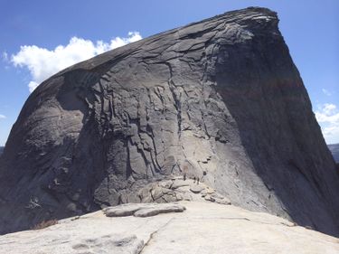
Half Dome
| Rating: | |||||||||||||||||||||||||||||||
|---|---|---|---|---|---|---|---|---|---|---|---|---|---|---|---|---|---|---|---|---|---|---|---|---|---|---|---|---|---|---|---|
| | Difficulty:POI 2A V (v1a1 V) Raps:
Red Tape:Permit required Shuttle:None Vehicle:Passenger | ||||||||||||||||||||||||||||||
| Location: | |||||||||||||||||||||||||||||||
| Condition Reports: | |||||||||||||||||||||||||||||||
| Best season: | Jul-Oct (avg for this region)
|
||||||||||||||||||||||||||||||
| Regions: | |||||||||||||||||||||||||||||||
Introduction[edit]
Approach[edit]
The Trail starts at the Happy Isles Bridge. There is a parking lot across from the campground next to the Happy Isle Visitor center. On many occasions this lot is full so street parking out at the meadows may be the only option or take a shuttle from various other parts in the park. Keep in mind that the shuttle direction only goes from the Meadows towards the Bridge at the start of your day. The end of the day means walking back.
Options in the hike include going through Vernal Falls and Nevada Falls as well as on the way back. When the waterfall is flowing, the stones and steps will be wet. If you catch the sunlight correctly, there will be rainbows on the mist of the waterfalls. Many people choose to go around these on the slightly more gradual John Muir Trail in the forest.
There will be a sign after the upper backpacker campground to turn to the Half Dome Trail. This is a very common point for a person to check hikers for the permits. The other place they check is at the saddle at the base of the cables.
Descent[edit]
Exit[edit]
Red tape[edit]
Permits are required for hiking to the top of Half Dome. http://www.nps.gov/yose/planyourvisit/hdwildpermits.htm
The steel cables overlook the valley and many people that have a fear of heights will usually not go past the saddle. Some people bring a harness and use the two tether each with a carabiner to clip on/off the cable between the post.
The steel cables are a large diameter & stranded. They are very smooth so we brought our own petzel leather gloves. There was a public box with various garden type of gloves for grip if you forget or want to take a chance that the sharing box is still there.
Beta sites[edit]
 Chris Brennen's Adventure Hikes (Southwest) : Half Dome
