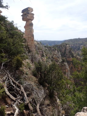
Hammer Hoodoo Canyon
| Rating: | |||||||||||||||||||||||||||||||
|---|---|---|---|---|---|---|---|---|---|---|---|---|---|---|---|---|---|---|---|---|---|---|---|---|---|---|---|---|---|---|---|
| | Difficulty:3A III (v3a1 IV) Raps:7-9, max ↨150ft
Red Tape:No permit required Shuttle:Required 10min or 1h Vehicle:High Clearance Rock type:Sandstone | ||||||||||||||||||||||||||||||
| Location: | |||||||||||||||||||||||||||||||
| Condition Reports: | 31 Jul 2022
"This is a really neat “cliffineering” route with lots of interesting scenery and quite a few fun large rappels!. We took the ridge approach from t |
||||||||||||||||||||||||||||||
| Best season: | May-Sep, HOT Jul-Aug
|
||||||||||||||||||||||||||||||
| Regions: | |||||||||||||||||||||||||||||||
Introduction[edit]
A rugged “cliffineering” route down to West Fork of Oak Creek canyon. This route features large hoodoo rock formations, lots of large cliff edge rappels, and multiple bouldery down climbs.
Approach[edit]
Drop a shuttle vehicle at Call of the Canyon parking area (fee required) or free parking may be found a bit up the road.
Long Shuttle
Take a high clearance vehicle up the 89A to FR 535 and follow the KML track to the parking pin. 4x4 may be required when roads are wet. This shuttle will take approximate 1 hour, one way, but eliminates nearly all up-hill hiking.
Short Shuttle
Park at the base of the 89A switchbacks (passenger vehicle accessible) and follow the ridge approach KML track as it climbs steeply up to the rim. There are one or two short 4th class sections and lots of scrambling on loose terrain. Hike along the rim, first following FR 535A and then working your way up and over a small hill to the head of the canyon.
Hike down through thorny brush and down logs to first rap.
Descent[edit]
R1: 60' tree LDC. View of hammer hoodoo LDC up.
R2: 120' tree over boulder. Watch rope in crack. Adjust rope to avoid abrasion on rope on sharp edge.
R3: 40' boulder.
Downclimb or optional 20' rappel.
R4: 30' tree LDC back.
R5: 60’ tree LDC back
R6: 150' boulder LDC.
R6: 80' tree back LDC.
R7: 135' large tree.
Exit[edit]
Complete a few downclimbs through the brush. Go RDC when brush/debris becomes too dense to easily negotiate. Meet with West Fork trail and follow it left (east) to shuttle vehicle.
Red tape[edit]
West Fork of Oak Creek trailhead for Exit vehicle is often crowded and parking limited. $11 per day. Call of the Canyon Picnic Site. Optionally, can find parking north up the road off of the highway.
Beta sites[edit]
 OnRopeCanyoneering.com : hammer hoodoo Canyon
