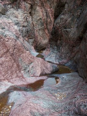
Hance Creek
| Rating: | |||||||||||||||||||||||||||||||
|---|---|---|---|---|---|---|---|---|---|---|---|---|---|---|---|---|---|---|---|---|---|---|---|---|---|---|---|---|---|---|---|
| | Difficulty:3B IV (v3a2 IV) Raps:0-4, max ↨50ft
Red Tape:No permit required Shuttle:None Vehicle:Passenger | ||||||||||||||||||||||||||||||
| Location: | |||||||||||||||||||||||||||||||
| Condition Reports: | 10 May 2025
"Extremely hot down in the canyon this time of year, as expected. Took the bypasses rather than going direct, and found them absolutely horrendous in e |
||||||||||||||||||||||||||||||
| Best season: | Mar-Apr;Fall
|
||||||||||||||||||||||||||||||
| Regions: | |||||||||||||||||||||||||||||||
Introduction[edit]
Hance Creek is described in Todd Martin's Grand Canyoneering book as a nontechical route which uses sketchy scree climbs to bypass each of the rappels.
Most experienced canyoneers will prefer to simply take rope and go direct, rather than climb halfway out of the canyon numerous times to avoid several small nuisance drops. As such, the route is advertised here as a technical canyoneering route.
Approach[edit]
Descent[edit]
The descent down Hance Creek to the Colorado River does contain a few minor vertical obstacles, which with some effort can be bypassed by scrambling around them. Since Grand Canyon bypasses are typically difficult to follow, steep, unstable, somewhat dangerous and almost never fun (and these in Hance are no exception), the recommended approach is to descend the canyon directly using ropes to rappel the falls in the canyon, then ascending them on the way back. The advantage to doing a technical descent is that it is less time and energy consuming to see the falls in the canyon by going right through them than it is to hike to a fall, then hike back up to and climb up and down a steep, chossy, 200-400 foot tall bypass, then hike back up canyon again to see the falls from below. The obvious drawback to this approach is having to carry ropes and technical gear to and from the canyon, so - pick your poison.
If descending the canyon directly (again, highly recommended), there are five significant vertical challenges to overcome:
The first is a little more than half way down the drainage and is a 10 foot tall drop at a chockstone (requiring about 20 feet of rope).
The second is right after the first and is a nice waterfall around 20 feet tall (needing 40 feet of rope).
More hiking will bring you to the third short drop which is only about six feet tall, but consists of a steep, smoothly polished chute. Getting back up this drop would be trivial with a group party where those on the bottom can boost and those on the top can pull up. Those travelling alone need to make sure they can get back up this obstacle unassisted.
The next obstacle is another fall of around 30 feet (requiring about 50 feet of rope), the shape of which makes it quite difficult to stay out of the water flow, so plan on getting a little wet - especially on the ascent.
Another chockstone drop appears as you near the river, is about 10 feet tall and can be negotiated by climbing down a fairly vertical crack on the right. The crack is hard to see until you are right on top of it, you can get a look at what you are dealing with by looking as far out as you can get on canyon left when standing on top of the drop. There are a few good hand holds at the top of the crack, but it thins out as you go down - the climb isn't without its difficulty, but it is quite short.
There is one more chockstone drop before reaching the river of about 15 feet. This one has a fairly short and easy bypass around it on canyon left that probably takes less time and energy than building an anchor and ascending would - this bypass route is cairned and pretty obvious.
Exit[edit]
Red tape[edit]
Beta sites[edit]
 Super Amazing Map : Hance Creek
 Grand Canyoneering Book by Todd Martin : Hance Creek
Trip reports and media[edit]
https://www.facebook.com/pat.winstanley.7/media_set?set=a.2034428586615828&type=3&uploaded=23
