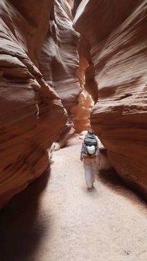
Happy Canyon
Jump to navigation
Jump to search
Also known as: Happy Canyon Narrows.
| Rating: | |||||||||||||||||||||||||||||||
|---|---|---|---|---|---|---|---|---|---|---|---|---|---|---|---|---|---|---|---|---|---|---|---|---|---|---|---|---|---|---|---|
| | Difficulty:1A III (v1a1 III) Raps:
Red Tape: Shuttle: Vehicle:4WD - High Clearance | ||||||||||||||||||||||||||||||
| Location: | |||||||||||||||||||||||||||||||
| Condition Reports: | 4 Jul 2017?
"extracts from Facebook posts, click link for full details (privacy restrictions may apply). " Happy 4th of July everyone. Be thankful and safe whe |
||||||||||||||||||||||||||||||
| Best season: | Any;HOT in Summer
|
||||||||||||||||||||||||||||||
| Regions: | |||||||||||||||||||||||||||||||
Automatic GPS data extraction NOT allowed, please visit roadtripryan.com to download GPX.
Introduction[edit]
It is no longer necessary to access via Burr Point. There is an easy, non-technical hike in on an old mining road that is 3 miles one way. Then the cairned trail down to the river. Access is from the end of Poison Spring Road Left bench road.
Approach[edit]
Descent[edit]
Exit[edit]
Red tape[edit]
Beta sites[edit]
 RoadTripRyan.com : Happy Canyon (via Burr Point)
 RoadTripRyan.com : Happy Canyon (via Poison Spring)
 Super Amazing Map : Happy Canyon
 SummitPost.org : Happy Canyon Narrows
