Hidden Canyon (North Cascades)
| Rating: | |||||||||||||||||||||||||||||||
|---|---|---|---|---|---|---|---|---|---|---|---|---|---|---|---|---|---|---|---|---|---|---|---|---|---|---|---|---|---|---|---|
| | Raps:16-18, max ↨120ft
Red Tape:No permit required Shuttle:None Vehicle:Passenger | ||||||||||||||||||||||||||||||
| Start: | |||||||||||||||||||||||||||||||
| Parking: | |||||||||||||||||||||||||||||||
| Condition Reports: | 24 Aug 2023
"The approach is a bit never ending, but otherwise not too terrible. Would likely become easier as the trail develops, but as of now its more non-exis |
||||||||||||||||||||||||||||||
| Best season: | Sept-Oct
|
||||||||||||||||||||||||||||||
| Regions: | |||||||||||||||||||||||||||||||
Introduction[edit]
Drainage area: 5.4sq. mi. Highest elevation point for the drainage is around ~6770 ft.
Waterflow: This canyon has not been run enough to determine which nearby gage might reflect the water flow levels.
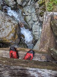
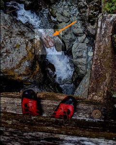
The red/brown rock visible in the water course from the bridge provides a useful way of comparing flow levels. At moderate-high there was clear water (rather than whitewater) pouring over it.
Approach[edit]
From the Baker River trail head, follow the Baker River Trail for about 2 miles. There is a bridge that crosses Hidden Creek -- use this as a waterflow checkpoint. Backtrack 150' from the bridge crossing and proceed uphill off-trail following the GPS track/lightly-trodden path. The off-trail section is 0.75 miles with an elevation gain of 1550'. Plan for the entire approach to take at least 3 hours. Drop in at (48.73582, -121.54530) at the elevation of 2450'.
Descent[edit]
CAUTION:
* Do not underestimate the technical rope work and team sequencing needed for this canyon. Your entire team should be comfortable navigating rooster tails and water chutes in slippery conditions. Belays are not always possible. Be sure to check pool depth for hazards (e.g. logs, boulders, and shallow pools) prior to sliding and jumping.
*There are traverses in the canyon which should be rigged for retrieval via self-belay or team belay techniques. Do not leave fixed lines in the canyon.
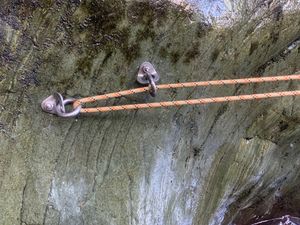
* This canyon utilizes a variety of anchors including unlinked bolts, v-threads, chain anchors, traverse bolts, natural anchors, and single bolts. Groups should be comfortable rigging these specific types of anchors. If you find two bolts side by side that are unlinked, do not add webbing to them. This canyon utilizes a v-thread (aka rock thread) for a rappelling anchor. Treat these as marginal anchors and use appropriate techniques to back them up (e.g. human anchors, removable bolts, etc). The cordage is made from 5 mm pure dyneema and tied off using a triple fisherman's bend.
DCL = down canyon left; DCR = down canyon right; S = slide; DC = down climb
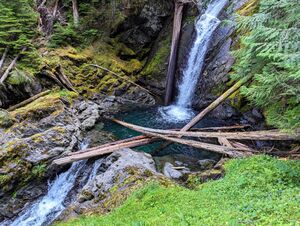
J1: 30’ DCR. Optional bonus jump. From the drop in, scramble up the canyon ledge DCR to reach the jumping platform.
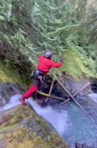
R1: 40’ DCR from unlinked bolts. The rope length is intentionally set to a longer length to accommodate crossing the pool and tying the end of the rope to the next station (R2)
R2: 80’ DCL from an in-line chain anchor.
R3: 20’ DCR a log.
R4 + traverse: DCL
- Traverse: 10’ from unlinked bolts
- Rappel (R4): 50’ from unlinked bolts
R5: 25’ DCR from unlinked bolts
R6: 60’ DCL from unlinked bolts
There is an open area after R6 to look back and admire the upper gorge, grab some food, and exit the canyon if needed.
ESCAPE DCR
The middle section narrows is the most constricted section of the route and the most pushy. It is possible to scramble up here and either exit and hike back, or re-enter below the middle section and still descend the lower section. Stay higher up on the cliff banks before finding a way back down to the creek. The alternative is to find a tree closer to the ledge and rappel closer to the waterfall. Take a moment to admire the u-turn the water follows.
The next four drops (R7 - R10) are the crux of the canyon. Solid personal movement skills are critical, as team rescue options are extremely limited. The rock is slippery and the rappels require careful footing and side stepping to cross over rooster tails and water chutes. Team sequencing and communication is advised as the R10 anchor station is not hospitable. Whistle signals will be very hard to hear.
MIDDLE NARROWS SECTION
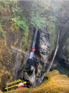
Downclimb 25' in a crack DCL with some diverted flow. At the bottom is a small channel. Duck under the flow to proceed to the next anchor.
R7: 50’ DCR from a single bolt anchor. Down a narrow chute and onto a slippery vertical log.
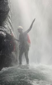
R8: 40’ DCR from a single bolt anchor. This is the crux rappel on the route. It is narrow and in full flow. Drop 20' onto a ledge behind the falls, get re-oriented, and then get ready to push through a thick curtain and continue down the lower tier.
LOWER SECTION
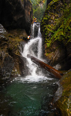
R9: 120’ DCL from an in-line chain anchor. Descend DCL of the rooster tail into the Monsoon Room. The rappel ends in a waist high pool.
R10: 50’ DCL from a single bolt anchor. A courtesy sling for folks to clip in to reach the anchor is recommended. Visibility is very limited here due to the heavy spray. Bump-and-Go is recommended here as an anchor manager is likely to get hypothermic if remaining for any length of time. The rappel exits into a deep pool. It may be possible to do a 30' slide in lieu of a rappel.
R11: 20’ DCR from a v-thread anchor high up. This rappel requires navigating through a log jam – check for loose logs.
R12: 50’ DCR from webbing around a log. Go under the rooster tail/log for a good time.
Downclimb DCR past a slippery log, then down a slippery slab DCR. Partner assist is recommended.
R13: 60’ DCR from a single bolt
R14: 20’ DCR from a single bolt anchor to the top of the next drop. The next drop is a slide. If you choose not to slide the next drop, set the rope length for 40’.
S1: 15’. Start the slide slightly left from the center of the flow.
R15: 30’ DCL from bolt
R16: 15’ DCR from a single bolt
R17 + traverse: DCL
- Traverse: 10’ from single bolt
- Rappel (R15): 100’ from unlinked bolts
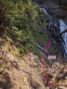
R18: 20’ DCR from a single bolt. Traverse across the rock slopes to reach the exit
Exit[edit]
Scramble up the steep slopes until you intersect the approach trail. Continue downhill until you reach the Lower Baker Trail. It is possible to cross Baker River to avoid most of the Lower Baker trail however this way requires walking over large pebbles and fording the Baker River which can be pushy. You'll save about 10 minutes if you decide to bypass the Baker River trail.
Red tape[edit]
A Northwest Forest pass is required to park at the Baker River Trailhead.
Beta sites[edit]
Trip reports and media[edit]
Background[edit]
Hidden Canyon was first descended on Aug 28, 2021 by Kevin Steffa, Jake Huddleston, Barry Specht, Andrew Humphreys, Haruka Clay Lipscomb, Ryan Ernst, Becca Poglase, and Tiffanie Lin. The team was finally able to complete this canyon after dreaming about it for 3 long years. On 8/10/2022 two more rappels were added in the middle section and subsequent rappels renumbered accordingly.
