Hidrofobia
| Rating: | |||||||||||||||||||||||||||||||
|---|---|---|---|---|---|---|---|---|---|---|---|---|---|---|---|---|---|---|---|---|---|---|---|---|---|---|---|---|---|---|---|
|
| |||||||||||||||||||||||||||||||
| | Raps:0+, max ↨0ft
Red Tape:No permit required Shuttle:Required 60 min Vehicle:High Clearance | ||||||||||||||||||||||||||||||
| Location: | |||||||||||||||||||||||||||||||
| Condition Reports: | 23 Mar 2026
"FANTASTIC canyon. No rappels, no hydraulics, nothing scary - just endless jumps and swims. There is a fair amount of boulder hopping at times, but you |
||||||||||||||||||||||||||||||
| Best season: | Mar-November
|
||||||||||||||||||||||||||||||
| Regions: | |||||||||||||||||||||||||||||||


Introduction
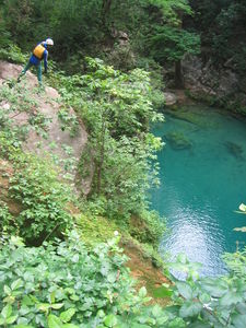
A fantastic canyon for those that like jumps & slides. This is the natural continuation of Chipitin but is usually descended on a different day due to its length and that it is non-technical (thus the ropes and gear for descending Chipitin are not required, although a group can arrange to have a burro carry out the gear from the base of Chipitin so they can continue with less weight). There are jumps up to 20' (higher jumps are optional). The upper part is quite open but the middle part descends through some beautiful hallways.
Beware poison oak throughout the canyon.
Life jackets are highly recommended due to so many long swims! There's probably over half a kilometer of swimming total in this canyon between the dozens and dozens of deep pools you have to cross.
Approach
Hidrofobia is accessed through the "Cascada del Chipitin" trail, which is the exit for the Chipitin canyon. When driving up to Potrero Redondo leave a return vehicle along the road at Las Adjuntas, at location 25.3011,-100.1417.
Note that near the start a local has a sign (and is standing there) demanding 60 pesos per person.
Descent
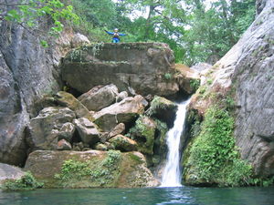
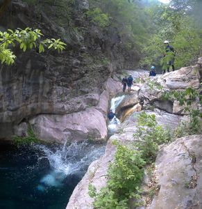
The canyon starts immediately below the "Cascada del Chipitin" with a 45' run & jump over a tree, but there is a trail to bypass this. Maybe 20 minutes thereafter is a tricky downclimb/handline off a travertine arch in a cave, on the left side of the whole riverbed. This is LDC in the flow. Or you can use a ratty, knotted handline (if it's there) that's a bit right of canyon center. Then comes a seemingly endless succession of jumps/slides all the way to the end. For the most aggressive jumps/slides if everyone in your group is not comfortable jumping, you will be able to find a downclimb or anchor to do a rappel or handline instead. For this reason it is recommended to bring an emergency 30-60' rope just in case. The highest 'mandatory' jump is only 5-6m (20').
There is an optional technical jump called "the Cube" that requires a 30' jump from a slanted slab in order to clear some dangerous rocks. This is the <!>S10 jump in the outline, and there is a photo of this below. The slab can be slippery and the rocks below are not visible from the top, but the rock can be downclimbed on the left (with help from a handline if present) for scouting, and it is very easy to clear the rocks if you do not hesitate at the edge of the jump.
45' run & jump over a tree at the start
30' run & jump from a slanted slab, 'the Cube'
Waterslide time!


Exit
This exit point for Hidrofobia is the same as Matacanes, at the busy place called Las Adjuntas. Descend the canyon all the way to the confluence with a big river, then take off wetsuits and hike up the river, following the ATV track until it intersects the main road.

Red tape
Lifejackets are required, and this is enforced by Protección Civil (though mostly during the summer high season).