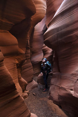
High Spur Canyon
| Rating: | |||||||||||||||||||||||||||||||
|---|---|---|---|---|---|---|---|---|---|---|---|---|---|---|---|---|---|---|---|---|---|---|---|---|---|---|---|---|---|---|---|
| | Difficulty:3A III (v3a1 III) Raps:1, max ↨85ft
Red Tape:No permit required Shuttle:Optional 2.7 mi Vehicle:High Clearance Rock type:Sandstone | ||||||||||||||||||||||||||||||
| Start: | |||||||||||||||||||||||||||||||
| Parking: | |||||||||||||||||||||||||||||||
| Shuttle: | |||||||||||||||||||||||||||||||
| Condition Reports: | 23 Nov 2025
"A few sections of jaw dropping sculpting and narrows with a ton of wash walking in between. We dropped in early at the very head of the canyon for ext |
||||||||||||||||||||||||||||||
| Best season: | Any;HOT in Summer;DIFFICULT in Winter
|
||||||||||||||||||||||||||||||
| Regions: | |||||||||||||||||||||||||||||||
Introduction[edit]
While not overly technical, High Spur features a long, stunning set of narrows right before the technical portion. Suitable for beginner canyoneers with adequate guidance, the crux of this canyon is likely the drive to the trailhead.
Approach[edit]
Leave Utah Route 24 to the east onto Lower San Rafael Road. This dirt road continues southeast for several miles until you come to a T intersection with farming/stock equipment on the right, continue on Lower San Rafael Road by turning left, passing over the shoulder between Little Flat Top and The Flat Tops. Follow this road for several miles until you come to another T intersection with an information board. Take the right fork labelled "Hans Flat Ranger Station" (Roost Road). Follow Roost road until you reach the ranger station and then turn left onto NP-777. (It's the road just to the right of the driveway up to the residence. It will pass a fenced off photovoltaic field). NP-777 is a fairly straightforward road with the exception of two slick-rock sections. A small sedan is unlikely to be able to navigate these sections, an unmodified rav/4runner/subi shouldn't have too much trouble with careful driving. Continue along this road until you come to a large intersection with a trailhead on the left. This is the start to High Spur Canyon.
Descent[edit]
Exit[edit]
From the bottom of the technical portion of the canyon continue ~10 minutes walk down-canyon. On your right there will be a large side canyon/breakdown that looks like an obvious escape. Head up the canyon navigating some sandy talus terrain until you reach the lip. There are two 4th class moves back-to-back. The first is a move to a corner on climbers right, then a few easy steps up into a traverse to climbers left. Experienced climbers/canyoneers won't think twice about these moves but more novice canyoneers will appreciate a body belay from the top.
Once on the top of the first rim continue cross country (please stay on the trail as there is beautiful crypto abound!) following the canyoneers trail until you reach the bottom of the second rim. Scamper up the slick rock to the much darker sandstone above. Here find one of several trails that will take you back to BLM 1202. Follow BLM 1202 east for ~2 miles until you make it back to the parking lot where you started.
Red tape[edit]
High Spur, while on BLM land is adjacent to the Glen Canyon National Recreation Area. While you should be fine to camp without a permit being in BLM land, you must pass through the park on the way to high spur. If you plan to camp either ensure you are outside the park and in BLM land or that you have obtained a backcountry permit from the Hans Flats Ranger station. At time of writing they were open 0800 - 1400.
Beta sites[edit]
 RoadTripRyan.com : High Spur Canyon
 Climb-Utah.com : High Spur
 CanyonCollective.com : High Spur
 Super Amazing Map : High Spur
 CanyonCollective.com : High Spur
Trip reports and media[edit]
 Candition.com : High Spur
