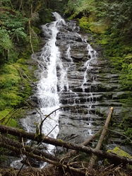
Hopkins Creek
| Rating: | |||||||||||||||||||||||||||||||
|---|---|---|---|---|---|---|---|---|---|---|---|---|---|---|---|---|---|---|---|---|---|---|---|---|---|---|---|---|---|---|---|
| | Raps:9, max ↨250ft
Red Tape:No permit required Shuttle:None Vehicle:Passenger | ||||||||||||||||||||||||||||||
| Start: | |||||||||||||||||||||||||||||||
| Parking: | |||||||||||||||||||||||||||||||
| Condition Reports: | |||||||||||||||||||||||||||||||
| Best season: | April-July, Nov-Dec,
|
||||||||||||||||||||||||||||||
| Regions: | |||||||||||||||||||||||||||||||
Introduction[edit]
Hopkins Creek is a beginner-friendly canyon featuring 9 drops and an impressive 250' waterfall. The approach is primarily on trail, the off-trail navigation and bushwhacking are friendly, easy exit, and the creek walking is straight forward. Hopkins has a similar canyon profile to Munra Creek in the Columbia River Gorge as it's open and non-committing.
- Watershed: 1.32mi^2. Highest point in the watershed is Prairie Mountain at about 5000ft in elevation.
Approach[edit]
Turn off onto Silverbrook Road and park in the pullout at the intersection. There's room for several vehicles.
Visiting the Checkpoint[edit]
From the parking area, walk north up Silverbrook Road 200ft. Note the first driveway on the right and the obvious trail heading up into the forest. Do NOT park here as it may upset the local residents. This is the exit trail and it's worth walking up the short 600ft to view the bottom of the last rappel. Please be respectful of the locals and avoid private property. Flow can also be checked at the highway bridge close to Silverbrook Road.
Hiking Up[edit]
From the cars, walk east along the shoulder of Hwy 12 for about five minutes. Several hundred feet after crossing Hopkins Creek watch for a dirt pullout on your left (beyond the road with houses that is on the left) and note a sandy trail blocked by fallen trees heading steeply up the embankment. Follow this dirty trail upward to reach the main trail in a couple hundred feet. The main trail is overgrown in summer, but push on through... it's not that bad and soon gets better. Follow the trail up to the end of a switchback at about 1700' - and proceed westerly off-trail until you reach Hopkins Creek. Depending on the season, you may cross a tiny seasonal stream before reaching Hopkins Creek. A good place to target is to drop into Hopkins just where a small tributary joins it at ~1800ft elevation.
Descent[edit]
The descent begins where a tributary East of Hopkins joins with Hopkins Creek. Natural anchors are abundant. Well-placed webbing exists at all drops. The creek is quite pristine and the webbing anchors low profile. .
R1: 70' DCR. This line is the crux in heavy flow. Totally doable at mod high. If too high, use a dry line from a tree around the corner DCR.
R2: 20' DCR
R3: 20'
R4: 100' DCL go under the log or split it
- R4a: ~80’ rappel to log R4b 20’ off log.
R5: ~250' Upper Hopkins Creek Falls. You have options! The falls can be descended in 1, 2, or 3 pitches.
- R5 - 250' single pitch descent. Bring radios for communication.
- R5a - 60ft to R5b. (Or 160' to R5c.) Anchor is a tree DCL.
- R5b - 90ft to R5c. (Or 200ft to the bottom.) Anchor is a large cedar DCL with a maple growing across it. The cedar has webbing & a quick link; the maple has an anchor made from an piece of canyon rope. The two separate anchors allow the anchor manager to clip in without getting wrapped up in the rappel line. This rebelay provides a nearly direct and dry fall line to the next anchor.
- Note: If rappelling directly from R5a to R5c, the rappeler must scramble up a very slippery slab to the top of the final pitch. Using R5b has good line-of-sight throughout the sequence and improves communication.
- R5c - 100ft to the bottom. Anchor is a tree DCL. The fall line stays out of the main flow, even during high water. At the bottom, you can optionally enter a side flow.
! Watch for rockfall at the base! Loose rocks are easily kicked down by rappelers.
R6: 60' DCL
R7: 70' DCL. Traverse ~25’ from sling around tree to access R7 rappel webbing.
R8: 80' DCL
R9: 180' DCL – Lower Hopkins Creek Falls There are 3-inch tree branches across the upper section of the falls. They don’t appear hazardous but are obstructive and should be trimmed with a saw. Significant debris and tree fall are present at the bottom of R9. Plan to land either down canyon left (DCL) or on top of the logjam.
Pull from DCL. Station someone at the logjam to manage the rope tail, it will get caught in the vertical logs within the flow. The waterfall is low-angle here, which makes it easier to free the rope from the debris.
Exit[edit]
Trail is DCR that will take you back to the parking lot. Please avoid going directly down the creek as there are houses nearby.
Red tape[edit]
The exit trail from the last falls leads out to Silverbrook Road, passing between two houses. Please be respectful of local residents and avoid private property. Randle police are constantly ticketing for speeding. Drive within the limits.
Beta sites[edit]
Trip reports and media[edit]
Facebook Album - first descent on December 10,2017
Background[edit]
This canyon was first descended on December 10, 2017 by Doug Hecker, Haruka Lipscomb, Jake Huddleston, Michelle Nilles, Gilly Elor, Sid Creutz, and Tiffanie Lin. There appears to be additional waterfalls around 2400'. Many thanks to Doug and Nick for sharing this canyon.


