Hunter Canyon
| Rating: | |||||||||||||||||||||||||||||||
|---|---|---|---|---|---|---|---|---|---|---|---|---|---|---|---|---|---|---|---|---|---|---|---|---|---|---|---|---|---|---|---|
| | Difficulty:3 (v3) Raps:max ↨125ft
Red Tape: Shuttle: | ||||||||||||||||||||||||||||||
| Location: | |||||||||||||||||||||||||||||||
| Condition Reports: | |||||||||||||||||||||||||||||||
| Best season: | Nov-Mar (avg for this region)
|
||||||||||||||||||||||||||||||
| Regions: | |||||||||||||||||||||||||||||||
Introduction[edit]
copy of the First Descent Team's Trip Report & write-up in 1993:
http://desertpeaks.org/archives/dps00295.htm
"On day two, we reached Bighorn spring at midday and explored its interesting millsite equipment with steam powered arrastre. At this point, we left the Lonesome Miner trail and started the 3,600' descent through lower Hunter canyon. As usual with the east side canyons, we immediately encountered riparian vegetation with some stretches of thick brush and lots of sign of Bighorn sheep. We walked through one strange stretch with a thick patch of bamboo like plant which extended above our heads. In several areas we hit marsh like areas of stagnant water and everyone took turns enjoying the opportunity to sink into deep muck - what a mess that made. The first rappel was encountered at 3,200'. It was 125' high with lots of flowing water creating a beautiful cascading waterfall. A short distance further at 3,020' we encountered our second rappel which was 35' high. At 2,880' we reached a 100' rappel and decided to camp at the top of the falls with its spectacular views down canyon. There were not many open spots for camping and we scattered about to scrap out small spots among the brush and rocks.
That night for the only time in my backcountry camping experience, I had problems with small mice. All night long, I was awakened by their moving around, running over my gear, and on one occasion, running across my hand. The periodic disturbance by mice did not bother me but I wondered if the excess of rodents might also be a harbinger of an excess of snakes - fortunately, I did not encounter any that night.
Success In Canyon No. 8
On day three, we went down rappel No. 3 which was 100' high and in two stages. From there, the lower canyon went fairly easy with just one short area of dense brush. we did an optional 4th rappel at 1,800' where there was a steep and wet 30' embankment. From there, a use trail lead out to the roadhead at the mouth of Hunter canyon at 1,780'. As it turned out, the brush and waterfalls in Hunter canyon were fairly mild compared to the other canyons and Hunter turned out to be the easiest canyon to descend after Daisy which has a trail its entire length. That ended our initial exploration of the spectacular eastside Inyo canyons. Of course, the volunteers are wanting to go back to each canyon for some more detailed inventorying. We also want to check our leads on other potential trails to add to our growing trail network in the proposed Inyo Wilderness area."
Approach[edit]
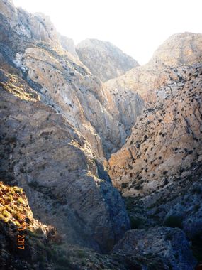
Banner photo taken at mid canyon looking down canyon. This was after a hike gaining over 6000 vertical feet to a camp there, on a scouting mission there for this canyon.
Descent[edit]
I have explored the lower section, and portions of the middle section of this canyon, for scouting purposes. But I am planning to complete the mission of exploring it all soon, to get a full review of it and updated report.
Exit[edit]
Red tape[edit]
Beta sites[edit]
Trip reports and media[edit]
Partial trip to sections of the canyon - not finished entire section yet:
5-13-17 https://www.facebook.com/scott.swaney/media_set?set=a.10155281040647930.1073742396.668617929&type=3
Earlier trip 1-15-12 exploring the lower portion of the canyon the day after another canyon trip the day before (Juniper Canyon - FD)
https://www.facebook.com/scott.swaney/media_set?set=a.10150598903397930.451275.668617929&type=3
