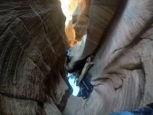
Immaculate Canyon
| Rating: | |||||||||||||||||||||||||||||||
|---|---|---|---|---|---|---|---|---|---|---|---|---|---|---|---|---|---|---|---|---|---|---|---|---|---|---|---|---|---|---|---|
| | Difficulty:3B III (v3a2 III) Raps:8-10, max ↨160ft
Red Tape:No permit required Shuttle:Optional 1h 15min Vehicle:High Clearance | ||||||||||||||||||||||||||||||
| Start: | |||||||||||||||||||||||||||||||
| Parking: | |||||||||||||||||||||||||||||||
| Shuttle: | |||||||||||||||||||||||||||||||
| Condition Reports: | 4 Oct 2025
"Pool at the base of R1/R2 can be avoided using a higher tree up RDC as an anchor. Some webbing look frayed so make sure to bring extra incase you want |
||||||||||||||||||||||||||||||
| Best season: | BEST in May;Jun;Aug;Sep
|
||||||||||||||||||||||||||||||
| Regions: | |||||||||||||||||||||||||||||||
Introduction[edit]
A sweet canyon with up to 10 rappels and a nice pay off at the end with several big raps up to 160ft ending with an optional sneak route back up to your vehicle. Variation in overall time is due to exit options. Wetsuit is generally not needed as the pools are usually not more than waist deep if one is careful. It is possible to do Immaculate and Insomnia from the same campsite without having to drive anywhere. Both have their own sneak routes back up to your car.
Loop Route Using Sneak Exit:
- Parking: 34.9974, -111.7915
- First Rappel: 35.0027, -111.7876
- Last Rappel: 35.0053, -111.7867
- Sneak Exit Left Up Drainage: 35.0055, -111.7867
- Top of Sneak Exit Head South: 35.0080, -111.7916
Approach[edit]
Driving
The driving route shown on the map (89A to 535 to 536 to 231 to 778) is a well graded dirt road that can be easily driven in a vehicle with moderate clearance such as a small SUV or crossover (as of Oct 2019). The drive time from the Call of the Canyon (COTC) trail head (West Fork Exit on 89A) to the Immaculate approach parking is approximately 1 hour and 15 minutes.
According to a different source, as of Jun 2021, the 535 is not well graded. Although a sedan made it through, it was quite rough with lots of opportunity to puncture a tire. Taking I40 to the 231 will give you the well graded (some washboard) road that will take about just as much time but be a lot better on your low clearance vehicle.
Hike
There is some mild bush-whacking on the short approach.
Descent[edit]
R1: 40' from a tree DCR into a water filled pothole. There is a less obvious anchor further DCR from a tree up the slope (looks like it could be used to avoid the pothole)
R2: 15' from a tree DCL into shallow pool. The traverse to the anchor for rap three could be nerve wracking for some, before pulling the rope there is an option for setting up a traverse line for more comfort
R3: 60' from a tree DCL to waist deep pothole, can avoid a second pool by going left.
R4: 150' from a tree DCL. Very cool slot rappel. Potential rope eater.
Stay left, rap 5 is up sloping hill.
R5: 100' from a tree DCL.
R6: 150' from a tree DCL. Partially overhung. Consider staying on rappel until you are able to tie in to the next anchor. (OR can be done as a 190 with a tricky pull, skipping R7)
R7: 30' from single bolt DCR to waist deep pothole. Log that may be used by some to keep dry.
R8: 160' from double bolts DCL to waist deep pool. May be possible to avoid pool with some climbing skills
R9: 15' from a single bolt DCR or 30' off natural arch.
Water levels may vary. A few rappels with some overhang/feet come off the wall. Several anchors have been modified which have eliminated the difficult rope pulls. With care, there is little to no risk of sticking your rope.
Exit[edit]
Shuttle Exit
Continue down the Immaculate drainage until it connects with West Fork. Hike along Oak Creek to the COTC trailhead.
Sneak Exit
After the last rap (15 footer) pack up your gear and walk a very short distance to where Immaculate drainage T’s into the drainage that you would normal take right down to West Fork. Take this drainage left and start heading up. You may find a faint trail which is relatively easy to follow, but the exit will be steep and on very loose dirt. When looking up this drainage you will see a sheer cliff on the left side so you know it’s the right one, head up this drainage finding the best route up which to me is staying on the drainage rocks for better footing otherwise you will be hiking up a lot of loose dirt and rock. As you continue up this canyon, about two thirds of the way up the drainage will fork. Stay in the main (right) drainage and continue all the way to the saddle. When you top out head directly south up a small hill to an old road that is over grown but noticeable. Its easy hiking at this point. You can follow this road south for a while until it takes you southwest around a drainage all the way back to the parking area.
Also be aware that some parties have encountered an active beehive approximately 700ft up the gully.
Beta sites[edit]
 Super Amazing Map : Immaculate Canyon
 HikeArizona.com : Immaculate Canyon
 OnRopeCanyoneering.com : Immaculate Canyon
- https://www.stavislost.com/hikes/trail/immaculate-canyon
Trip reports and media[edit]
Background[edit]
Canyon was first descended in 2012 by Brian Bassett, Mark Yarch, and Chris Ngo. Sneak exit discovered by Jay Wisocki and Dinna Marquez.


