Inaxos
| Rating: | ||||||||||||||||
|---|---|---|---|---|---|---|---|---|---|---|---|---|---|---|---|---|
| | Raps:40, max ↨115ft
Red Tape:No permit required Shuttle: Vehicle:Passenger | |||||||||||||||
| Location: | APPROXIMATE LOCATION! "°37'51.00"N" can not be assigned to a declared number type with value 37."°29'39.00"E" can not be assigned to a declared number type with value 22.
|
|||||||||||||||
| Condition Reports: | ||||||||||||||||
| Best season: | ||||||||||||||||
| Regions: | ||||||||||||||||
Introduction[edit]
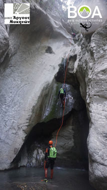
Inahos, discovered in 2011 by the canyoning community, is an interesting and fun canyon with about 40 rappels, easily divided to 4 roughly equal sections, with many short (5-7m) and bigger (~15m) rappels, with the biggest being 35m. Access is easy, there are 2 easy escapes and another one that is not so easy, but is an option in emergencies. However, most of the canyon has open sections that are escapable in an emergency. There are a lot of undergroung springs that fall into the canyon, so water level at the entrance may not be indicative of the water level inside or at the exit. The canyon is on the north side of mt. Artemisio and ends up forming the river Inahos, which travels all the way to the Argolis gulf. The river is dry most of the year.
In the summer of 2019, the local Municipality of Argos-Mykines provided all the necessary materials for properly anchoring the canyon and, in two 10 hour expeditions, BOA - Base Outdoor Activities installed anchorage in all waterfalls (almost all of them have chains or belay stations).
There is also a side canyon close to the main entrance that meets the main canyon at around the 30th waterfall.
Approach[edit]
You can drive to the parking spot either from the village Nestani or from Karia. The road from Nestani is asphalted and easier. The road from Karia is mostly asphalted, except a 2-3km gravel section and is longer. Unless you are already in the Karia area, it makes sense to go through Nestani. You can park next to the road and organise equipment there. The entrance to the canyon is a 600m downslope hike away and the route is marked with green spray.
Descent[edit]
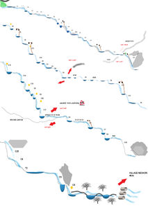
The canyon has 3 main escapes and it can be divided into 4 rougly equal sections. The 1st and 2nd escape lead back to the car for easier logistics, but can also be used as entrances. The 3rd escape is 3km on rough, sloped and unstable terrain. It is preferrable to continue the descent through the canyon, unless that is impossible (e.g. high water or damaged equipment).
The 1st section (waterfalls 1-11) is the easiest one and most inviting to beginners. All rappels are less than 8m with no difficult points. There is minimal walking from one waterfall to the next. The escape is to the right, marked with three green dots. You need to climb the wall (easy climb, no special skills or equipment needed) and walk through the sparse vegetation back to the car (about 800m).
The 2nd section (waterfalls (12-20) is more interesting, starting with a beatiful 22m rappel under a huge stuck rock and continues with a few 10-15m rappels. A few underground springs empty inside this section, so water levels may be elevated in relation to the 1st section. Similarly, the escape is to the right, marked with three green dots, at a point where the canyon opens. After an easy climb, there is a marked route through dense, but easily traversable vegetation, which leads back to the car (about 1km).
An option with easy logistics is to descend the first two sections and return back to the car.
The 3rd section (waterfalls 21-31) is the most interesting and challenging one, with continuous 15m waterfalls, some of them into deep pools, even during the dry season. Some sections are open and require walking. The escape is to the left, marked with three green dots and leads to an ancient hiking path, called Lykopati (wolf path). However, it is over rugged, sloped and potentially dangerous terrain, so it should only be used when the normal descent of the canyon is deemed impossible (e.g. due to high water or damaged/lost essential equipment). The path leads to the closest village, called Neohori.
The 4th and final section (waterfalls 32-40) includes an impressive 30m rappel, followed by a 10m rappel though a human sized hole. This point was probably a deep pool in the past, where the water found an escape. In limited water, there is no danger, but in high water, it's possible that this will create a dangerous syphon, so caution is advised.
Another option is to use the 2nd escape as an entrance point and descend the 3rd and 4th section only, cutting the descent time in half.
Exit[edit]
After the final rappel, the canyon meets a gravel road, which can act as the exit parking. Alternatively, the team can park at the village Neohori and walk the 3km of the gravel road.
Red tape[edit]
No restrictions, no permit needed. There are several spots to camp in the area, just respect and be nice to the locals who have sheepfolds there and are not used to visitors.

