Koda Creek
| Rating: | |||||||||||||||||||||||||||||||
|---|---|---|---|---|---|---|---|---|---|---|---|---|---|---|---|---|---|---|---|---|---|---|---|---|---|---|---|---|---|---|---|
| | Raps:4-5, max ↨200ft
Red Tape:No permit required Shuttle:Optional 10min Vehicle:Passenger | ||||||||||||||||||||||||||||||
| Location: | |||||||||||||||||||||||||||||||
| Condition Reports: | 8 Jun 2025
"Downclimbed/slid R1, removed old torn up webbing from R2 tree and ghosted it. R4 was a fun rappel. The downclimb groove is a cool little narrows. Foll |
||||||||||||||||||||||||||||||
| Best season: | Apr-Jul, BEST in May-June
|
||||||||||||||||||||||||||||||
| Regions: | |||||||||||||||||||||||||||||||
Introduction[edit]
A small tributary dropping into Paradise Creek with some very nice rappels. Be aware, the climb out is nasty. It actually might be worth dropping by the exit before entering the creek and leaving a rim rope there for your return (see "Exit" below). Alternately, plan to hike out via the creek and leave a shuttle down at the campground. Doing Koda sans shuttle is about a half-day adventure and leaves plenty of time to visit Backwoods Brewing in Carson.
Watershed: 1.34mi^2.
Approach[edit]
From the Paradise Creek Campground, follow the Wind River Rd north towards Old Man Pass for 3mi. Turn off left on FR 102 (approx. UTM 10N 582950mE 5092285mN)and follow it for 1.2mi to a saddle just above Koda Creek. Watch for elk.
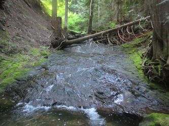
From the parking area, bushwhack west (easy) for 0.25mi to drop into the creek. Go downstream a few hundred feet to reach the place where Koda Creek abruptly drops off into the valley. A nice area of bedrock marks the final approach to the falls.
- Checkpoint is right at the top of the falls.
Descent[edit]
- 10ft ramp. Downclimb or rappel.
- R1: 100ft low-angle ramp. Might be tempting to downclimb, but going for a tumble could be Very Bad.
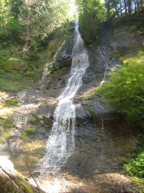
- R2 & R3: Koda Falls. 270ft relatively steep bedrock ramp all the way down. Anchored on a tree DCR. A 200ft rope obviously will not reach, so if you don't have a 300ft rope in the quiver, you'll need to break it up into two rappels. Stop at a relatively flat spot 2/3rds of the way down and set an intermediate anchor on a tree. Very aesthetic falls.
- R4: 150ft. In high flow the creek divides around a tree island. We anchored on a tree on the island and went down the DCR channel. Nice bedrock bowl below the falls.
- 15ft step. Downclimb groove DCR.
Exit[edit]
Sadly, Koda Creek is short & sweet. Head downstream about 0.15mi, passing some large house-sized boulders. On the DCL side of the creek watch for an obvious gully which is the best-looking place to exit the creek that you’ve seen yet. Follow the gully up and out of the creek, and, when you can, climb up onto the nose of the ridge to climber’s left. Head on up the ridge (steep) wherever is easiest until reaching a headwall. This is the crux of Koda. Bear slightly left into a dirty gully and grovel your way up perhaps 100ft, digging out steps for footholds, until the terrain eases off. For safety, might be good for the first person up to trail a rope, then tie it off to a tree up at the top. Rope can then be used to ascend out by the rest of the team.
Above the headwall, walk through open forest (easy) trending northeast. Follow an obvious mini-ridge that appears on your left. Circle around a large bowl-like collapsed area to you right/south (possible old landslide where the hillside gave way). Follow it northeast for two minutes to reach the road and walk back to your car.
- It might not be a bad idea to visit the top of the exit gully before descending Koda and set a rim rope to make the life easier. Top of the gully is at approx. UTM 10N 581447mE 5091210mN.
- More exploration of the area might locate an easier route up through the cliffs...?
- Another option is to hike the creek out to a shuttle down on FR 30. This has not been explored and looks long.
Red tape[edit]
None.
Beta sites[edit]
Trip reports and media[edit]
Background[edit]
First descent by Kevin Clark, Wade Hewitt and Keith Campbell in June 2019.

