Lake Creek (Baker River)
| Rating: | |||||||||||||||||||||||||||||||
|---|---|---|---|---|---|---|---|---|---|---|---|---|---|---|---|---|---|---|---|---|---|---|---|---|---|---|---|---|---|---|---|
| | Raps:14-16, max ↨160ft
Red Tape: Shuttle:None Vehicle:Passenger | ||||||||||||||||||||||||||||||
| Location: | |||||||||||||||||||||||||||||||
| Condition Reports: | 30 Jul 2023
"A nice day out in the always charming Lake Creek. Flow was low for this time of year. All bolts in good shape. We replaced all webbing on natural anch |
||||||||||||||||||||||||||||||
| Best season: | Summer, Fall (avg for this region)
|
||||||||||||||||||||||||||||||
| Regions: | |||||||||||||||||||||||||||||||
Introduction[edit]
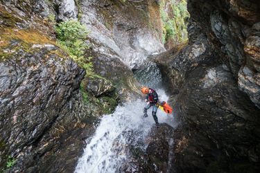
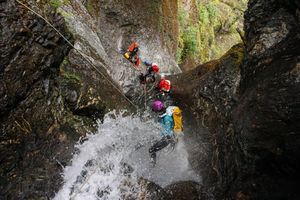
Lake Creek is located within Mount Baker-Snoqualmie National Forest in Whatcom County, Washington. It is a tributary of the Baker River and is sourced by Shuksan Lake. The waters of Lake Creek have carved an impressive and winding canyon that has snaked its way through black, white, and red speckled bedrock. The approach is quite long and strenuous, and typically takes 3-4 hours, with the majority of the elevation gain off trail. Some groups have had difficulty navigating the approach. Your effort is rewarded however with 17+ back-to-back rappels in a unique and winding creek tucked away into the hills of the Baker River.
An early start is recommended for this canyon, as well as an efficient team with strong rappelling and rigging skills.
Lake Creek in the Mount Baker-Snoqualmie National Forest should not be confused with the Lake Creek in Wenatchee National Forest.
Approach[edit]
Drive[edit]
From Washington Highway 20 East, turn left (north) on Baker Lake Rd and travel 26 miles until the road ends at the Baker River Trail parking area. You will need a Northwest Forest pass to park at the trail head or alternatively pay $5 for a day-use pass.
Google Maps directions to parking area
Hike[edit]
Hike along the relatively flat Baker River Trail for 2 miles. Just before you reach the bridge that crosses Lake Creek, veer off-trail into the woods, following the path of least resistance while paralleling the creek. Once you reach the hillside, look for traces of old flagging tape on trees. This flagging marks an old single track trail. The uphill portion of the approach is very steep and will take several hours. If you lose the flagging prior to 2,400', you may be too far off track. Continue climbing until 2400' and begin traversing across the hillside towards the creek. You will cross several small gullies before the final obstacle, a 10-15 minute thick bushwhack through vine maples before reaching the drop-in. If you need to rappel to get into the canyon, you are likely too low and need to continue uphill to the drop-in.
Enter the canyon around ~2200'. Suit up at the creek.
Descent[edit]
DCR = Down Canyon Right
DCL = Down Canyon Left
This canyon utilizes many natural anchors that can be damaged/washed away each season. If you think you may be the first group through of the season, be prepared to inspect and rebuild all anchors. All natural and bolted anchors use webbing and quick links, so bring plenty. A drill kit is also useful for the first descent of the season in the event of damaged bolt anchors.
R1: 110' DCL - unlinked bolts down a 2-stage rappel
R2: 100' - log
R3: 50' DCL - unlinked bolt
R4: 60' DCR - rock pinch
R5: 70' DCR - single bolt (2 stage low-angle rappel). The second stage has been done as a short slide.
R6: 40' DCR - log. This rappel leads directly to a hanging pothole where R7 is located. R7 is an exposed anchor.
R7: 80' DCL - unlinked bolts
R8: 30' - boulder in the creekbed
R9: 10' - Partnered assist downclimb. Lots of anchor material here to rig a quick line if needed
R10: 25' DCL - log, or careful downclimb
R11: 60' DCR - log (2 stage rappel)
R12: 80' DCL - bolted webbing anchor on large boulder. This anchor is exposed and awkward to reach. Use protection as needed.
R13: 40' DCR - log
R14: 20' DCL - log
R15: 60' DCR - bolted webbing anchor
R16: 25' - logjam
R17: This is a multi-pitch rappel with a hanging rebelay anchor. This rappel sequence is the grand finale to the canyon with great views of the valley below.
R17 Pitch 1: 60' from a logjam into a pothole. Carefully climb out of the pothole and stay on rope to reach the bolted rebelay anchor DCL.
R17 Pitch 2: 130' DCL - bolted webbing anchor. The final 90' of this rappel is not visible from the anchor.
Exit[edit]
After the last waterfall, walk downstream (either directly in the stream or back into the forest) to the Baker River Trail. Follow the Baker River Trail south for 2 miles back to the parking area.
Red tape[edit]
None
Beta sites[edit]
Lake Creek Falls - Northwest Waterfall Survey
Trip reports and media[edit]
Background[edit]
This canyon was first descended by: Kevin Steffa, Tre C Kwan, Erik Bernhoft, Haruka James Lipscomb, Pt Choate, Tommy Kelly, Jake Huddleston, and Tiffanie Lin on a cloudy and sporadically-rainy- Fall-came-early day on Sept 8, 2018. The flow was moderate low and thankfully the rain was minimal during the descent. The canyon was scouted both by Jesse Houser, Kevin Steffa, and Tiffanie Lin on various dates prior to the first descent.
Credits (chronological order)[edit]
Page contributions by (contributors needed, you could be the first). Please read the Disclaimers.


