Leale
| Rating: | |||||||||||||||||||||||||||||||
|---|---|---|---|---|---|---|---|---|---|---|---|---|---|---|---|---|---|---|---|---|---|---|---|---|---|---|---|---|---|---|---|
| | Raps:10, max ↨66ft
Red Tape: Shuttle:Optional 4Km Vehicle:Passenger Rock type:Limestone | ||||||||||||||||||||||||||||||
| Start: | |||||||||||||||||||||||||||||||
| Parking: | |||||||||||||||||||||||||||||||
| Shuttle: | |||||||||||||||||||||||||||||||
| Condition Reports: | |||||||||||||||||||||||||||||||
| Best season: | Jul - Sep
|
||||||||||||||||||||||||||||||
| Regions: | |||||||||||||||||||||||||||||||
Introduction[edit]
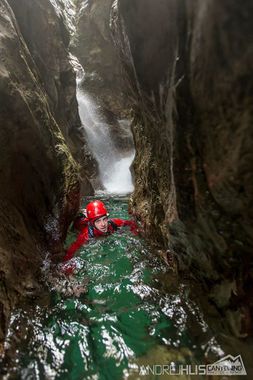
Rather short but beautiful and aquatic canyon with a good mix of jumps and rappels. Leale has a big catchment bassin and is only doable after periods without rain.
Approach[edit]
The old approach from above shouldn't be used anymore due to it crossing private property, so only the approach from below is described. From Alesso drive in the direction of Avasinis. After you cross the bridge over Torrente Leale pass a house and turn sharply to the right on a rather narrow sand road. Ford Leale and follow the road to its end where you can park.
If not doing a car shuttle: From the valley parking, continue in the forest following the obvious path that reaches the dam. Climb up the dam on the river-right bank (marked with the white/blue ProCanyon signs). Continue in the river bed until it divides in two and cross the pool of water on your left that leads towards the final narrow section of the canyon. A little before this narrow section, on your right (river-left), hidden in the vegetation, starts the path (marked PC) that climbs steeply. At the point where you clearly see the riverbed, follow the track down to the canyon (marked PC on a rock). Once you reach the riverbed, walk upstream for a few tens of metres, until you reach the point where the Riu dal Boschet enters into Leale. Cross the river Leale to the bank that lies opposite where the Riu dal Boschet enters, you should see PC markings for the approach to the upper section. The path starts in a steep climb and then flattens, but the path is not very clear due to vegetation. Descend towards the riverbed on an steep and slippery downhill path that reaches the arch over Leale and the start of the canyoning route.
Descent[edit]
The canyon consists of a short upper part and a longer lower part, seperated by a stretch of easy walking. Key passages are an aquatic 4m rappel in the first part and an impressive 15m drop in the second part. Jumps possible up to 10m
Exit[edit]
Red tape[edit]
Beta sites[edit]
 Descente-Canyon.com : Leale
 Canyon.Carto.net : Torrente Leale
 Altisud.com : Leale; cotation: V4-A4-4
 Catastoforre AIC-Canyoning.it : Torrente Leale
 Canyoneast.it : LEALE
 Canyoning in the Alps Book by Simon Flower : Leale (Lower)
