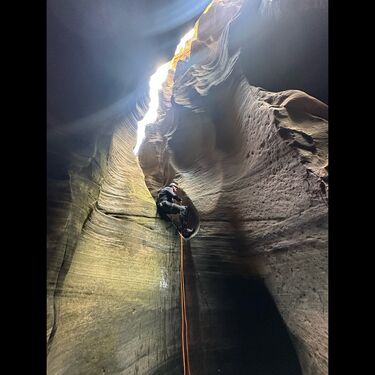
Left Fork (Upper)
| Rating: | ||||
|---|---|---|---|---|
| | Raps:max ↨60ft
Red Tape: Shuttle: | |||
| Location: | ||||
| Condition Reports: | 25 May 2025
"The upper section doesn’t have anything unique compared to the standard Das Boot section. It is a lot more work to get to the upper section and the |
|||
| Best season: | ||||
| Regions: | ||||
Introduction[edit]
The Upper Left Fork is the section of the Left Fork of North Creek just up canyon from the Das Boot section. The permit required for either the standard Das Boot route or the Upper Left Fork portion are the same. The park calls labels the permit as "Upper Left Fork (Das Boot).
The Upper Left Fork can be accessed from either the West Rim Trailhead or the Wildcat Canyon Trailhead.
Approach[edit]
Take the standard approach for the Subway that begins from the Wildcat Canyon trailhead. Follow the Subway trail to where it crosses Russell Gulch. After crossing Russell Gulch, the standard Subway route climbs slickrock to a small pass, For Das Boot, you want to hike up to the higher pass, where the red and white sandstone layers meet. Rather than dropping into the standard Das Boot section, keep contouring around on the slickrock ledge. At the corner, climb up to the notch on the left, then down steep dirt and a slickrock rib on the other side. There is an emerging trail here, but simply work your way down to the canyon floor. Continue east/northeast to where the Upper Great West Canyon makes a sharp turn southwest, and enter here.
Descent[edit]
Once in canyon there are a few short rappels and possible keeper pothole. Pothole escape gear recommended.
Exit[edit]
If you only have Das Boot (Upper Left Fork) permits then exit by ascending the standard approach Subway approach back to the Wildcat Canyon Trailhead.
If you have Subway permits exit via the Subway (see details on the Zion Subway)
Red tape[edit]
Beta sites[edit]
 Super Amazing Map : Upper Left Fork
 Zion Canyoneering Book by Tom Jones : Left Fork - Full
