Leprechaun Canyon (Middle Fork)
| Rating: | |||||||||||||||||||||||||||||||
|---|---|---|---|---|---|---|---|---|---|---|---|---|---|---|---|---|---|---|---|---|---|---|---|---|---|---|---|---|---|---|---|
|
| |||||||||||||||||||||||||||||||
| | Difficulty:3A II PG (v4a1 II) Raps:1-4, max ↨25ft
Red Tape:Permit required Shuttle:Optional Vehicle:Passenger Rock type:Sandstone | ||||||||||||||||||||||||||||||
| Location: | |||||||||||||||||||||||||||||||
| Condition Reports: | 3 Oct 2024
"Leave early, before 9. Do not take helmets, you do not need them. Eat a big breakfast and camel up before leaving your car. Maybe take a gallon jug of |
||||||||||||||||||||||||||||||
| Best season: | Any; hot in Summer, cold in winter
|
||||||||||||||||||||||||||||||
| Regions: | |||||||||||||||||||||||||||||||
_Banner.jpg)
Introduction
A narrow slot canyon, the most challenging of the Irish. Most can stay low the whole way. Optional high-stemming to 20 feet. If you like this one and crave more and higher stemming, you may be ready for a real R slot canyon in nearby West Butlers or Trachyte or Ticaboo.
Approach
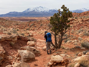
Leprechaun Canyon can be explored using two primary approaches: a bottom-up hike starting near Highway 95 or a top-down route beginning at the upper trailhead accessible via the Turkey Knob dirt road.
Top-Down Approach
The upper trailhead is located along Turkey Knob Road, a dirt road passable to most vehicles, although high-clearance is recommended. This road is marked on most maps, so detailed directions are not included here. Pro Tip: Parking can become crowded. Turn your vehicle around when parking to avoid maneuvering difficulties later.
From the trailhead, several social trails lead southward following natural watercourses but two routes are most prominent. To minimize environmental impact, stick to these established routes, which should appear on most modern maps.
Western Approach Drainage: This is best for reaching the West or Middle Leprechaun Forks.
- Take the western route which initially heads toward what will become the Middle Leprechaun drainage but intersects a well-defined social trail before reaching it.
- At the trail intersection, rather than taking the trail, continue down the drainage into Middle Leprechaun Canyon as it begins to slot up.
(Alternative) Eastern Approach Drainage: This this approach drainage is most suitable for accessing the East Leprechaun Fork, and while it will get you to the other forks, it is a less efficient option for doing so.
Bottom-Up Approach
Near Highway 95, a short dirt road next to the Leprechaun Canyon drainage provides an ideal parking area for your starting/exit vehicle. From this point:
- Begin hiking up the main wash.
- Look out for a notable side canyon joining from the west (left side, up-canyon).
- At this juncture, leave the drainage and ascend the slickrock nose that lies between the main wash and the side canyon. Avoid entering the side canyon, as it dead-ends.
- Climb the slickrock ridge, which naturally divides the two drainages. While cairns may mark the route, continue ascending to stay on track. As you approach the top, before reaching the mesa, the terrain flattens and transitions to dirt. Shift leftward toward the top of the side drainage.
- A well-defined social trail begins here and should be easy to follow. The trail will lead you into a small draw and then up onto the mesa top, offering stunning views of Leprechaun Canyon and its forks to the east.
- Continue along the trail as it traces the canyon rim. (Note: This trail will guide you to all forks of Leprechaun Canyon or the upper trailhead.)
- The trail will cross the West Fork of Leprechaun Canyon and another shallow drainage before curving to the southeast and encountering a trail junction in another shallow drainage. This junction is easily recognizable from the top-down approach, but may or may not be apparent from the trail.
- At the trail intersection, leave the trail and head down the drainage into Middle Leprechaun Canyon as it begins to slot up.
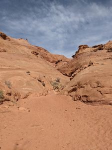
Fork where route climbs out of river bed
Start of the middle fork
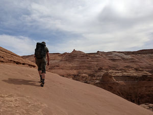
Maybe half the approach is on rock.


Descent
The Middle Fork of Leprechaun Canyon begins with two tiny branches at the top, either of which can be used to start the descent. Both involve technical drops and rappels. The eastern branch is considered the standard entry, while the western branch provides a solid alternative. These two quickly merge, leading into the main canyon.
Within the main canyon there is only one rappel, but a significant amount of technical stemming is required. The canyon follows a distinct rhythm: sections that are still narrow but more open and comfortable alternate with tighter constrictions that demand sustained stemming. After each technical stretch, there’s usually a brief reprieve before the canyon narrows again.
As you progress, each skinny section becomes progressively narrower. The final stretch is the tightest of all, eventually opening out at the junction with the West Fork. Keep in mind that if you find the early sections challenging, the stemming will only get tighter further down. That said, it is generally possible to stem up and over each constriction—though not always easy for everyone.
Eastern (Standard) Branch Start
- R1 / Downclimb:
- R2: 30 feet - Anchored from pinch point.
Western (Alternative) Branch Start
- R1 Alt: 20 feet - Anchored from a dead man anchor and drops about 20 feet.
- R2 Alt: 30 feet - Anchored from a choke stone and drops about 30 feet.
Main Canyon
- R3: 25 feet - Anchored from a rock fin.
Photos of Descent
_1.jpg)
_2.jpg)
_3.jpg)
_4.jpg)
_5.jpg)

Some stemming required for our group
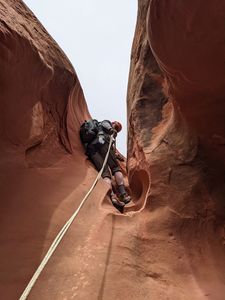
Second rappel
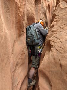
Lots of tight squeezes
_pic1.jpg)
_rap2.jpg)
_tight.jpg)
Exit
Once through the narrow section the canyon opens up to a stunning corridor with sheer walls arching up on both sides. Take a moment to enjoy this spot and gear down then continue down canyon as the cliff walls recede and the canyon opens up into a draw. Follow the main sandy wash back to the highway.
Red tape
Permits
Due to a high volume of search and rescue incidents, the Garfield County Sheriff's Office now requires all individuals to obtain a FREE PERMIT before entering this canyon. Entering without a valid permit may result in a Class B misdemeanor.
For more information and to obtain your permit, visit: https://www.brycecanyoncountry.com/permits/
Beta sites
 BluuGnome.com : Leprechaun Canyon - Middle Fork
- RoadTripRyan.com : Leprechaun Canyon
- Climb-Utah.com : Leprechaun Canyon- North Wash
- Super Amazing Map : Middle Leprechaun
- CanyonCollective.com : Leprechaun Middle Fork
- CanyoneeringUSA.com : Leprechauns-3 Technical Forks
- SummitPost.org : Leprechaun Canyon
Trip reports and media
- Candition.com : Leprechaun Canyon; North Wash
- YouTube.com : Richard Pattison, Leprechaun Canyon middle fork movie