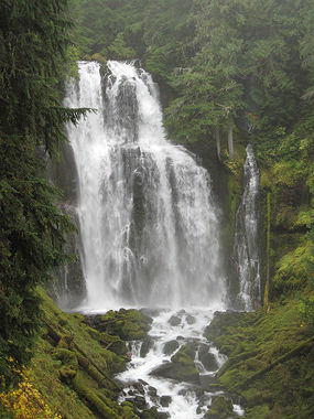
Linton Creek
Jump to navigation
Jump to search
The exploration of this location has not yet been documented All information is unverified estimation | |||||||||||||||||||||||||||||||
|---|---|---|---|---|---|---|---|---|---|---|---|---|---|---|---|---|---|---|---|---|---|---|---|---|---|---|---|---|---|---|---|
| Rating: | |||||||||||||||||||||||||||||||
| | Raps:7, max ↨150ft
Red Tape:No permit required Shuttle:None Vehicle:Passenger | ||||||||||||||||||||||||||||||
| Location: | |||||||||||||||||||||||||||||||
| Condition Reports: | |||||||||||||||||||||||||||||||
| Best season: | Jul-Sept
|
||||||||||||||||||||||||||||||
| Regions: | |||||||||||||||||||||||||||||||
Introduction[edit]
This waterfall has not yet been descended. KML map key is as follows:
F(#) = Falls number, starting form the top downstream R(#) = Rappel number, starting from the top down. If it dos not have a 'R' it can be bypassed P(#) = plunge type, vertical, approximate height C(#)= cascade style falls , approximate height D(#,#) = Double falls, Heights listed from top to bottom
Approach[edit]
From the Linton Lakes trailhead, follow the trail about 1.5mi to Linton Lake. From there bushwhack up the ridge east of the creek.
Descent[edit]
The technical descent begins at about 4500ft elevation.
- 15ft - can bypass?
- 15ft - can bypass?
- R1: 20ft
- 10ft - can bypass?
- 10ft - can bypass?
- 10ft cascade - can bypass?
Bit of a walk.
- R2: two stage: 15ft & 30ft.
Bit of a walk.
- 20ft - can bypass?
- 10ft - can bypass?
- R3: 45ft
- R4: 35ft
- R5: 20ft
- R6: two stage: 30ft, 90ft.
Bit of a walk.
- R7: Linton Falls - 125ft.
Exit[edit]
Follow the trail back the way you came.
Red tape[edit]
- A Northwest Forest Pass is required to park at the trailhead.
- A Central Cascades Wilderness Permit is required for overnight trips.
- The entire creek is inside the Three Sisters Wilderness area. Power drills and drones are not permitted.
