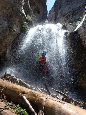
Little Falls
| Rating: | |||||||||||||||||||||||||||||||
|---|---|---|---|---|---|---|---|---|---|---|---|---|---|---|---|---|---|---|---|---|---|---|---|---|---|---|---|---|---|---|---|
| | Raps:4-7, max ↨75ft
Red Tape: Shuttle: Vehicle:Passenger Rock type:limestone | ||||||||||||||||||||||||||||||
| Location: | |||||||||||||||||||||||||||||||
| Condition Reports: | 14 Jun 2023
"Little falls is in perfect form right now. Gushing from top to bottom, but manageably so. Additional raps are required compared to low flow or no flow |
||||||||||||||||||||||||||||||
| Best season: | spring to fall, can be snowy in winter
|
||||||||||||||||||||||||||||||
| Regions: | |||||||||||||||||||||||||||||||
Introduction[edit]
This is a fun canyon up in the cool alpine forests of the Spring Mountains. It is often slippery and debris-filled. It can present class C conditions with snowmelt (potentially into summer in years with high snow accumulation) and after heavy summer rains. the rest of the time it's class B or potentially A.
Approach[edit]
follow the Cathedral Rock trail up until it flattens out on a saddle before climbing to the peak. bear left on a wide trail that topos around the ridge to the left. leave the trail and drop in to the right as indicated on the KML, before reaching the actual stream bed. you will see the bolt for the first drop on a flat rock soon after leaving the trail.
Descent[edit]
after the first rap of ~60', you will encounter a series of drops, most anchored off bolts, some off of the many logs littering the canyon floor. several spots with anchors are easy downclimbs in low flow conditions. you're literally walking across logs for most of this canyon, and they can be very slippery when wet. the 75' rappel is two stage that could easily be broken up into a ~20' and ~45 foot by building an anchor of one of several dead logs in a hanging pothole. the two stage rap is around a corner but the rock is smooth and does not seem to present pull issues (though the rap side could potentially fall into the hanging pothole and snag a branch)
Exit[edit]
easy walk down canyon to the trail back to your car
Red tape[edit]
Beta sites[edit]
- Las Vegas Slots Facebook Beta
 Las Vegas Slots Book by Rick Ianiello : Little Falls
 CanyonCollective.com : Little Falls
- BirdAndHike
Trip reports and media[edit]
https://adamhaydock.blogspot.com/2017/06/little-falls-mtcharleston-nevada.html
