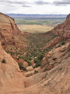
Lizzard Canyon
| Rating: | |||||||||||||||||||||||||||||||
|---|---|---|---|---|---|---|---|---|---|---|---|---|---|---|---|---|---|---|---|---|---|---|---|---|---|---|---|---|---|---|---|
| | Difficulty:3A II (v3a1 II) Raps:4, max ↨160ft
Red Tape: Shuttle:Required 3.3 miles Vehicle:Passenger Rock type:Desert Sandstone | ||||||||||||||||||||||||||||||
| Start: | |||||||||||||||||||||||||||||||
| Parking: | |||||||||||||||||||||||||||||||
| Shuttle: | |||||||||||||||||||||||||||||||
| Condition Reports: | |||||||||||||||||||||||||||||||
| Best season: | Any, avoid winter ice
|
||||||||||||||||||||||||||||||
| Regions: | |||||||||||||||||||||||||||||||
Introduction[edit]
Fun, easy access/exit, very scenic, mostly beginner friendly, technical canyon in the CNM
Approach[edit]
Park a return vehicle along Rimrock Dr at the Redlands View turnout.
Drive 3.3 miles up to Park the top vehicle at the Visitor's Center. This is a great canyon if already camping at the Saddlehorn campground in the A or B loops as that would cut off some of the short approach distance.
Hike toward the campground from the Visitor's Center. Head right toward the C loop and depart the road when the first shallow drainage comes in toward the north before the bathroom on the C Loop. Hike to a power line pole (39.10797, -108.73043) at the top of the canyon.
Old Notes: this canyon was first done by parking a shuttle vehicle on Mirador CT., which is an empty street about a quarter mile east of the west entrance to the Monument on the South side of Broadway, but required crossing private land. Scott Patterson recommended parking at Lower Monument Trailhead instead to avoid trespassing, as that is only a little longer hike on a trail, but all on public land.
Descent[edit]
R1: 160' from an existing sling around a small tree near the lip. (original beta: The first rap is 190' that descends down a couple of terraces that we anchored off of a tree with a fiddlestick to avoid rope scars, a noticeable anchor, and to avoid camper temptation to descend and get hurt.)
R2: 105' from huge rock in Canyon Center for two terraces with a great platform in the middle.
R3: 90' from rock in Canyon Center also with a great platform in the middle.
R4: 150' from a rock in the wash. (original beta: or slung tree on the bench DCR or off a tree on the bench DCL to avoid a tricky pull)
Exit[edit]
After the rappels, continue down the wash for 0.6 miles. When the canyon opens, hike up the ridge DCL to reach the road (0.1 miles +100'). Walk Rimrock Dr uphill to the Redlands View parking area.
To reach the Lower Monument Canyon TH:
Edit by Scott Patterson: Once the canyon opens up, you can look for a trail to the right. This takes you to the Wedding Canyon Trail and the Lower Monument Canyon Trailhead. There is a trail, no fence to climb, and no trespassing.
Shuttle back up to retrieve your first vehicle
Red tape[edit]
A National Park's pass or a Colorado National Monument entrance fee is required for parking.
Beta sites[edit]
Trip reports and media[edit]
Background[edit]
First descent by Scott Bordon, Nathan Dehart, Kyle Fullerton, Stephen Fullerton, Kelsey Ross, and Joe Uberhausen 4/29/2017
