Long Canyon (Wet Beaver Wilderness)
| Rating: | |||||||||||||||||||||||||||||||
|---|---|---|---|---|---|---|---|---|---|---|---|---|---|---|---|---|---|---|---|---|---|---|---|---|---|---|---|---|---|---|---|
| | Difficulty:3B III (v2a2 III) Raps:1, max ↨20ft
Red Tape:No permit required Shuttle:None Vehicle:Passenger Rock type:Sandstone | ||||||||||||||||||||||||||||||
| Location: | |||||||||||||||||||||||||||||||
| Condition Reports: | 7 Feb 2025
"Approached and exited via bikes. After an excessively dry fall and winter, the canyon was mostly dried up with only a couple wades up to waist depth. |
||||||||||||||||||||||||||||||
| Best season: | May to June, September to November
|
||||||||||||||||||||||||||||||
| Regions: | |||||||||||||||||||||||||||||||
Introduction[edit]
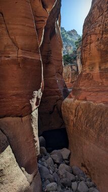
Long Canyon may slightly remind you of Bear Canyon on the Mogollon Rim of Arizona. It only has one rappel of 20 feet near the bottom after most of the slot has past. Although the canyon is not very technical, the slotted sections above the one rappel are some of the more beautiful in the area and reminiscent of the narrows of Bear Canyon, but longer. If looking to get your tech on, this is not the best choice, but if looking for a rarely visited hike through an absolutely gorgeous slot canyon, this may be a your ticket.
Approach[edit]
Take the Bell Trail East of I-17 to Bell Crossing and head up the steep trail most of the way to the top of the Mesa after having crossed Wet Beaver Creek. Once almost to the top you will see a steep scree slope that you will need to climb up and over the saddle into the main Long Canyon drainage. Scramble carefully down the steep hill on the other side and to the bottom of Long Canyon, and head into the canyon.
Alternate Approach[edit]
Skip the big approaches and monster hikes. Ride a MTB up the Bell Trail two track to the wilderness boundary. Then hike to where Bell crosses wet beaver creek and proceed downstream to the confluence of long. Head up the canyon 0.7 miles, to all the good narrows that are at the bottom of the drainage. You will have the short 25ft up climb to get access but it is a mild 4th class climb. Come back and enjoy the crack with the extra time.
2.7 mile bike to boundary (hike if you want….🥵) 1 mile hike 0.7 mile up canyon Crack time after. 3-5 hours
Descent[edit]
Simple downclimbs and cold swims will take you through this beautiful slot. Near the end a 20 foot rappel off of boulders takes place, before swimming and hiking the final bit to reach Wet Beaver Creek and the Bell Trail.
Exit[edit]
Take the Bell Trail back to your car.
Red tape[edit]
Beta sites[edit]
Trip reports and media[edit]
Background[edit]
First known descent was made in 2011 by Melissa Philibeck and Garrett Bennett, although due to the one rappel it seems possible that the route could have been descended and had the anchor wash away long ago... if not that, this route seems like prime terrain for the Native's living in the area over many centuries, so I feel certain we were not the first in this canyon by any means. Nonetheless this is a gorgeous canyon to explore.
