Lost Nozzle
| Rating: | |||||||||||||||||||||||||||||||
|---|---|---|---|---|---|---|---|---|---|---|---|---|---|---|---|---|---|---|---|---|---|---|---|---|---|---|---|---|---|---|---|
| | Difficulty:3B III (v4a2 IV) Raps:4-6, max ↨150ft
Red Tape:No permit required Shuttle:None Vehicle:4WD - High Clearance | ||||||||||||||||||||||||||||||
| Start: | |||||||||||||||||||||||||||||||
| Parking: | |||||||||||||||||||||||||||||||
| Condition Reports: | 5 Aug 2023
"This canyon looked... way better on Google Earth. Would recommend returning earlier in the season when there might be some proper flow. |
||||||||||||||||||||||||||||||
| Best season: | April-Jun
|
||||||||||||||||||||||||||||||
| Regions: | |||||||||||||||||||||||||||||||
Introduction[edit]
This small-drainage canyon shows promise as an enjoyable option for the early season in the Sierras.
Approach[edit]
Drive to the end of the road (or as far as you're willing to go in your car) and follow the trail downhill. Following the KML, pass one small, mostly-dry drainage to the second drainage and start downstream. Choosing the first drainage will drop you into the same canyon prior to the first vertical obstacle, and could be explored as well.
Descent[edit]
Complete a series of crumbly downclimbs, rappels from natural anchors, and small jumps to descend the canyon. The vertical obstacles are very roughly:
R1 - 50' rappel or downclimb. Rappel from a shrub DCR or downclimb on crumbly rock.
R2 - 150'
R3 - 150' from a large boulder in the watercourse down a mossy, spread waterfall
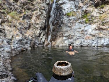
R4 - 50' from a small pine DCR. Take an optional 5' jump at the bottom into a deep pool. Look in the pool for the piece of equipment the canyon was named for.
Rappel lengths are approximate - bring enough rope to spare.
Exit[edit]
After finishing the vertical descent, follow the stream for a short time down to Canyon Creek. Get properly wet in the creek before starting the steep, hot, scree-filled climb up. Following the dry creek bed for the first 1/3 of the exit can provide pretty stable footing. From there, follow the scree ridge of the slope until the walls begin, go over / around to the right. The hill flattens out sharply after that. Bushwhack through 30 horizontal feet of Manzanita, then walk the remaining 10 minutes to your car.
Red tape[edit]
Beta sites[edit]
Trip reports and media[edit]
Background[edit]
First documented descent in August 2023 by feroz, sqshemet, and ameister.
