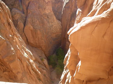
Lost and Found Canyon
| Rating: | |||||||||||||||||||||||||||||||
|---|---|---|---|---|---|---|---|---|---|---|---|---|---|---|---|---|---|---|---|---|---|---|---|---|---|---|---|---|---|---|---|
| | Difficulty:3A III (v3a1 III) Raps:3, max ↨132ft
Red Tape:Permit required Shuttle: Vehicle:High Clearance | ||||||||||||||||||||||||||||||
| Location: | |||||||||||||||||||||||||||||||
| Condition Reports: | 8 Nov 2025
"Road out to the trailhead requires some clearance, but isnt bad. We combined this with MMI for a full day. Took the climbers exit and while there ar |
||||||||||||||||||||||||||||||
| Best season: | Fall, Winter, Spring
|
||||||||||||||||||||||||||||||
| Regions: | |||||||||||||||||||||||||||||||
Introduction[edit]
The technical section is located within Arches NP and a permit is required. Permits are obtained through Recreation.gov (see Red Tape section below). Access is by driving up to I-70 and exiting Yellow Cat and passing through Yellow Cat Mesa.
Getting There[edit]
Drive 19 mile on dirt road that has sand and a bumpy clearance section at the end. There are stories of cars getting stuck.
Approach[edit]
From the parking area at the fence line, follow the remains of an old 4x4 trail running due north and paralleling the fence. At the point the track fades out take the first drainage northwest untill in encounters the main Lost and Found drainage running westward. Once in the main L&F drainage follow it until you encounter the first rappel.
Descent[edit]
Fun with some tight narrow sections, a tight section to crawl under. A few multi-stage raps.
All three rappels are bolted with two glue-in bolts. The final anchor has sepparated chains. The chains are intentionally not connected so as to prevent a log from potentially getting caught in the chains during a flash flood and ripping out the bolts. If you are new to this type of anchor just treat it the same way you would any other anchor with a single quick link--only now there are two "quicklinks" as the final link in each chain is effectively a quicklink.
Exit[edit]
Climber's Exit[edit]
The standard exit is up the official NPS-established "Climbers Exit" to the Covert Arch trail. Follow the Lost and Found drainage until it opens up and you reach a junction with the MMI drainage joining from the south. Turn south and briefly follow the MMI drainage while keeping a lookout for a small foot path on the west that can be difficult to spot. There may or may not be a small NPS sign at the path way.
Once you find the start of the Climbers' Exit proceed up the path staying on the slickrock. The exit slab climb is approximately 80’ of class 4 exposure (fairly easy with careful foot placements (rarely need to use hands), but a slip/fall would have severe consequences). There are 3 bolts to protect this section and it is possible for a leader, once up the pitch, to belay others up. Once above this slab section go up to a wall and then traverse left to exit to the rim. There will be a use trail along the rim back to the car. Look for rocks and park signs for the use trail to avoid stepping on the cryptobiotic soil and vegetation. The Climbers Exit is not recommended when wet or snow covered as it would be hazardous if not impossible to exit under those conditions.
Hiker's Exit[edit]
Alternatively the canyon can be exited via the Hiker's Exit to the Lost Spring Hiker's Exit Trailhead. This is also known as the Long, or Winter Exit as it is the route required to exit if ice, snow, or water is present on the Climber's Exit. This exit option will require setting up a car shuttle in advance, however.
Red Tape[edit]
Permits[edit]
A permit is required for any and all canyoneering within the boundaries of Arches National Park. Permits have group-size limits that varies depending on canyon or route. Permits cost $6 for a group and currently there is no quota limit, but that might change at some point in the future. A separate permit is required for each canyoneering route.
Permits must be obtained online through the link below and are available online 8:00AM MT one day in advance up to 5:00PM MT the day of the trip. The permit must also be readily available, printed or on a mobile device, during the trip should a ranger ask to see it.
- Permit Link: https://www.recreation.gov/permits/4251908
Group-Size Limits[edit]
Canyoneering groups are limited to a maximum of 6 people for this canyon.
Larger groups sharing the same affiliation (school, church, club, scout group, family, friends, etc., or combination thereof) may divide into groups smaller groups provided they do not occupy the same canyon, drainage, general area, or the same route on the same day and also have the necessary permits.
- Canyoneering regulations are available here: https://www.nps.gov/arch/planyourvisit/canyoneer.htm
Park Entrance Fee:[edit]
A NPS park entry fee or park pass is required. Additionally, a timed-entry reservation may be required to enter Arches National Park.
Timed Entry Reservations:[edit]
- Information about timed-entry reservations is available through the park's website: https://www.nps.gov/arch/planyourvisit/timed-entry-reservation.htm
- Timed-entry reservations must be obtained online here: https://www.recreation.gov/timed-entry/10088426
Beta sites[edit]
 RoadTripRyan.com : Lost and Found Canyon
 Climb-Utah.com : Undercover Canyon - Arches National Park
 Super Amazing Map : Undercover Canyon
 Moab Canyoneering Book by Derek A. Wolfe : Lost and Found Canyon
 SummitPost.org : Lost and Found Canyon
Trip reports and media[edit]
- Climb Utah Undercover Canyon Video
 Candition.com : Lost and Found Canyon
 Candition.com : Undercover
http://www.bogley.com/forum/showthread.php?77372-UnderCover-Lost-amp-found-Arches-NP-10-09-2017
