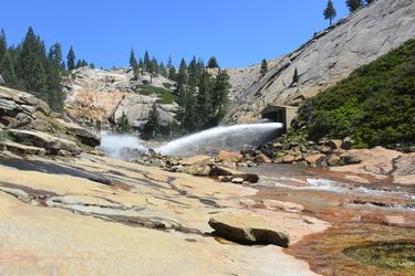
Lower Bear River (Crack Addiction)
| Rating: | |||||||||||||||||||||||||||||||
|---|---|---|---|---|---|---|---|---|---|---|---|---|---|---|---|---|---|---|---|---|---|---|---|---|---|---|---|---|---|---|---|
| | Raps:2-6, max ↨60ft
Red Tape:No permit required Shuttle:Optional 30 min Rock type:Granite | ||||||||||||||||||||||||||||||
| Location: | |||||||||||||||||||||||||||||||
| Condition Reports: | 22 Sep 2025
"Stunning canyon that runs between granite domes with lots of interesting features. A new favorite in California. Water flows in from the bottom of the |
||||||||||||||||||||||||||||||
| Best season: | Aug-Sep
|
||||||||||||||||||||||||||||||
| Regions: | |||||||||||||||||||||||||||||||
Introduction[edit]
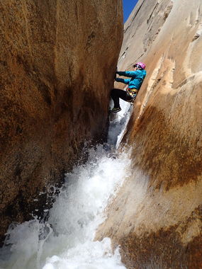
A very short but spectacular canyon. The main feature is the crack gorge, a dramatic intersection of two granite domes that form a crack. As the water comes out of the reservoir, it is quite chilly, so be prepared for it.
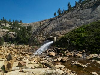
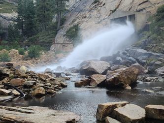
There is a USGS guage at the outflow of the dam. Like many USGS gauges, there can be significant back logs in the data, such that flow rates are only published several months afterwards.
The few recorded full descents 5-7 cfs seem to be good flow, probably wouldn't want too much more than 8. Unfortunately, real time flows are not available for this gauge, so one must be prepared to measure and/or compare flows at the drop in.
Below is a list of conditions known from recorded descents (automated waterflow analysis is currently not picking up the above USGS gauge properly):
- October 17th, 2010 (First Descent) - 5 cfs, low flows.
- July 5th, 2013 - 7 cfs, moderate flows.
- July 2nd, 2016 - 21 cfs, extreme flows. Escaped after R1 on canyon right.
- July 31st, 2016 - 19 cfs, extreme flows. The crux (R4) was bypassed completely climbing out on the slabs with an exposed 5.7 climb.
- September 3rd, 2016 - 7.5 cfs, moderate flows.
Approach[edit]
The approach is from the back of the dam. More specifically, park on the North side of the dam and take the dirt road down to the water.
Descent[edit]
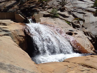
The canyon starts out mellow, with some jumps and slides, some of them can be quite technical at high flow. Eventually you're stemming over the current, which is awesome, and then it drops off into a series of waterfalls. Some drops have dual bolts, other have single bolts and other have no bolts at all and require mandatory jumps. The crack gorge bolts could get ripped out with higher water, so bring a bolt kit to be safe or a strong climber ready to do some exposed climbs in order to avoid the danger.
- Rap 0: this drop is downclimbeable, but some people have set an anchor on a tree DCR that can be useful in high flow conditions. You might as well use it too.
- Jump: this is 12ft technical jump off a ledge on the left to bypass a waterfall with a small pothole at the top. Lower someone first to check depth, if not comfortable with the jump you can rappel using a hook in a small pinhole or knot chock on the ledge. In high flows, this ledge may be difficult to approach, in which case a shallow ledge can be accessed on canyon right by scrambling up several feet on 4th class rock, and a jump of 20' can be made off of the sloping rock.
- Rap 1: off a chock rock back from the drop in a pile a small boulders mid river.
- Rap 2: webbing sling tied around a partially submerged boudler down in the water against the river right wall, right at the edge of the drop.
- Rap 3: double bolted high up on the right wall at a pyramid shaped rock. In high flow there might be an hydraulic at the bottom of this drop, one strong enough to hold you in, but it's narrow and if you stem, you should be able to easily force yourself through.
- Rap 4: two single bolts on the river right wall in the crack gorge. One of the bolts is back from the edge of the drop and the other 15ft down almost right at the edge, which makes the pull down easier and allows better visual contact with the people on rappel. Rap or handline from the first bolt down to the second station, then rap from here to the bottom of the falls. This is the crux of the descent, in high flow this rappel can become extremely dangerous. The hydraulics are strong at the base of the falls and could VERY easily coil and knot up any excess rope thrown down over the drop for rappelling. Best to set rope length and use a single line rappel system. Make sure to use a rope bag system attached to the last rappeller to dispense the pull line, and when at the edge of the drop have him throw down the bag to the pool for the rest of the team to hold on while he rappels in the strong flow. Respect this drop. Also take note of flows and make sure you don't go in with more than 10 cfs. Some groups went in at 18cfs and were forced to bypass the gorge rappel by climbing out on the slabs right before R4: "There is a 5'6-5'7 slab climb up the wall that is not too bad with stealth rubber. From the top of that climb it is easy, but very exposed class 3 slab down canyon and will drop you out below the gorge."
- Keeper Eddy: below rap 4 is a beautiful chamber to swim out of, with a keeper eddy just down stream. To underestimate this obstacle in high flow would be fatal. In high flow strong recirculating current will hold back and pull underwater both people and packs. Have a strong swimmer go first without a pack to get past the eddy and then have a throw rope ready for the rest of the team. In high flow you may be forced to use flat jumps, floating anchors or other advanced techniques to get past this obstacle.
- R5 and R6: downstream are two more waterfalls that can be climbed down on the left, but are now bolted and more fun to rappel
- R7: A little further down is a big waterfall bypassed on the left that could also make for a nice high jump (check depth first!)
Exit[edit]
Somewhere downstream there are some nice tea cups. Right around there a forest road almost gets to the river and allows for a comfortable exit. If you set up a shuttle, get out on the left. If you only took one car, head out Rattlesnake Creek on the right and make your way through the woods back to the car (adds about 2h to the overall time for the descent). Alternatively there is a nice cairn trail that follows the edge of the granite dome and the crest of the hill back to an old dirt road that goes back to the dam.
Red tape[edit]
link title==Trip reports and media==
- Album from 07/05/2013, under low flow conditions
- Album from 07/02/2016, under extreme flow conditions (bailed before R1 but after a committing jump out of a gulley on canyon right)
- Album from Sep 2016, under moderate flows
- Video of highlights of the canyon Roughly 6 cfs on September 2nd 2024
- Video of R4 (crux) from 07/31/2016, estimated water flow of 16cfs (extreme).
Background[edit]
The canyon was first descended on 16 Oct 2010 by Jef Levin, Michelle, Sue, Nathan, and Roman
This canyon was descended from the spillway to the pools at the bottom by the furthest downstream dome (Scimitar Dome) by Chad Suchoski solo in 2008. It was reported to have been descended possibly as early as the late 1970’s by Rick Sumner and Jay Smith but details of that descent are unknown.
