Lower Chambers Creek (Sleep Disorder)
| Rating: | |||||||||||||||||||||||||||||||
|---|---|---|---|---|---|---|---|---|---|---|---|---|---|---|---|---|---|---|---|---|---|---|---|---|---|---|---|---|---|---|---|
|
| |||||||||||||||||||||||||||||||
| | Raps:8-10, max ↨195ft
Red Tape:No permit required Shuttle:Optional 1 mi Vehicle:Passenger | ||||||||||||||||||||||||||||||
| Location: | |||||||||||||||||||||||||||||||
| Condition Reports: | 16 Jul 2023
"It was a HOT day (high of 103) and, as is par for the course, we got a later start than we hoped. Some of thats our own fault (why do I always think |
||||||||||||||||||||||||||||||
| Best season: | Jun-Oct
|
||||||||||||||||||||||||||||||
| Regions: | |||||||||||||||||||||||||||||||
_Banner.jpg)
-20230719233131_pic.jpg)
Introduction
A lush, steep, granite technical canyon with exciting rappels when done in the watercourse. Most rappels in the flow happen where the creek spreads out, or can be avoided, so this canyon is likely runnable earlier in the season, or in high-water years.
Conditions can be checked at the footbridge at the drop in, but can also be assessed when dropping off an exit vehicle; if the creek looks like something you can walk and scramble in at the exit, the canyon probably goes.
Approach
Leave a car at the exit shown on the map (dirt road, though usually accessible by passenger vehicle), and drive a mile down the road to the approach trailhead.
The approach is pretty straightforward, just make sure to turn right, crossing a small stream, when the hiking trail branches off the dirt road (100 yards from the parking lot and easy to miss). The approach is a steady uphill climb and has full sun exposure, with very little shade; it can be very hot in the summer. Bring plenty of water.
Once you reach a footbridge, that's where the canyon starts. Suit up and jump in the water bypassing the first waterfall (the "siphon").
Checkpoint: Standing in the middle of the footbridge, check the water flow by looking down at the "siphon" and comparing the amount of whitewater with the pictures below.
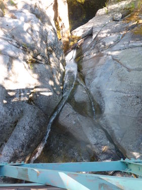
normal water flow (Jul 2014), safe to descend by experienced canyoneers
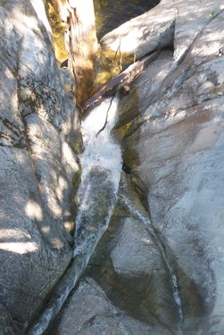
zoomed in version, a stronger flow will produce a larger whitewater area


Descent
From the top of the canyon, the rappels start immediately and continue in quick succession. You will likely do between 8-10, depending on conditions.
Some trip reports indicate that the longest rappel is only 100’. The original beta stated it was 195’. In July 2023, we estimated it at 160’, with another at 130’.
- R1: 160’ from a tree DCL. The end of this rappel is in the watercourse.
- R2: 80’ from a tree up DCR
- R3: 90’ from a slung boulder in the watercourse.
- R4: Climb up and over slabs on the right to a 130’ from a tree. This rappel is probably the most beautiful in the canyon, descending over wide, spread out falls. Send your best photographer down first.
- Down climb the crack DCL
- R5: 30’ from a large, deadish tree DCR. The tree was burned in the recent fire, but is large and still seemed stable. Future groups should assess the anchor carefully.
- Short section of creek walking.
- R6: 50’ from a dead tree DCR. There are several options to rappel on dead trees, or a scramble down to a living tree, but the rappel line is in brush. It may also be possible to extend R5, but the rappel would take you into an area of condensed flow. This is likely fine in low water, but may be dangerous in higher flows.
- R7: 50’ from a dead tree DCR. There may be a walk around up DCR, but we did not investigate.
- R8: 40’ from a boulder DCL
- R9: Scramble up and over DCR to a curvy tree. 100’. When on rappel, there is a tight crack to rappeller’s right that all the water flows through. It may be possible to rap in the flow here in low water conditions, but stay left and dry in high water.
- R10: 30’ DCR from a tree.
From here, creek walk and boulder hop your way down the creek to your car. There are one or two areas with tricky down climbs, where some people may need assistance.
Exit
Red tape
Beta sites
- Beta was originally posted on sierracanyons.org (now defunct), Open PDF