Maclac
Jump to navigation
Jump to search
Also known as: Barranc de Maclac.
| Rating: | |||||||||||||||||||||||||||||||
|---|---|---|---|---|---|---|---|---|---|---|---|---|---|---|---|---|---|---|---|---|---|---|---|---|---|---|---|---|---|---|---|
| | Raps:max ↨164ft
Red Tape: Shuttle:None Rock type:Limestone | ||||||||||||||||||||||||||||||
| Location: | |||||||||||||||||||||||||||||||
| Condition Reports: | |||||||||||||||||||||||||||||||
| Best season: | Anytime
|
||||||||||||||||||||||||||||||
| Regions: | |||||||||||||||||||||||||||||||
GPS data automatically extracted from wikiloc.com, please visit their site for more detailed information.
Introduction
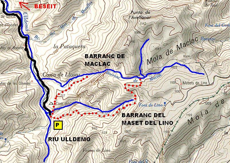
Acceso desde: Beseit - Beceite
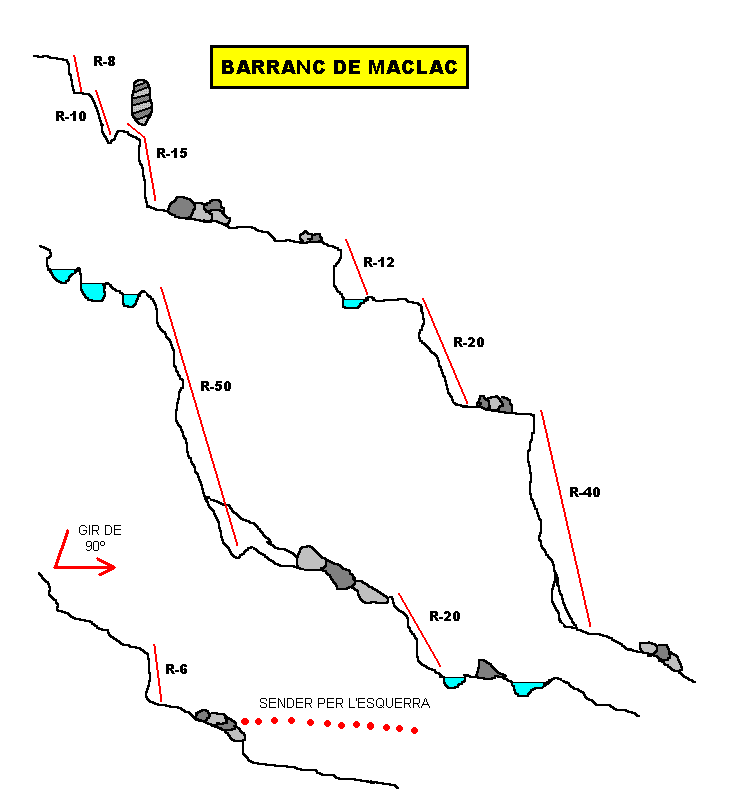
Altura de rápel mas largo: 50 m
Información del caudal: 100% seco
Material necesario: 2 x 50 + cuerda de socorro
Neopreno: No
Material de instalación: Aconsejable llevar material de instalación de repuesto
Epoca: En toda época
Observaciones: Barranco abierto, fácil y muy seco. Salva rápidamente un fuerte desnivel
Horario de aproximación: 1 h
Horario de descenso: 2 -3 h
Horario de retorno: 15 m
Mapa: Ed. Piolet, El Port, 1:30.000
Zona o macizo: els ports
Cuenca: Riu Ulldemo, Riu Matarranya
Altura en inicio: 900m
Altura en final: 750m
Longitud: 1,2 Km
Desnivel: 150m
Carácter: Abierto
Tipo de roca: Caliza
Combinable con el descenso de: Penyagalera Racó de les Olles, Barranc del Maset del Lino
Approach
Combinación de vehículos: No es necesaria
Desde Beseit, de la plaza de arriba que hay las escuelas, salimos por el camino en dirección a les Pesqueres (hay carteles), llegaremos al final y dejaremos el vehiculo.Cogeremos un sendero que sale por nuestra izquierda, cruzaremos un lecho (Barranc del Mases del Lino), una vez pasada un pequeño cuello, dejaremos el sendero e iremos hacia la izquierda en busca del barranco.
Descent
Escapes: En todo momento
Exit
Unos 100m después del último rápel, cogeremos un sendero que salta un cuello y va al parking.
Red tape
Beta sites
 Barranquismo.net : Maclac
- Wiki-Infobarrancos : Barranco de Maclac (http://infobarrancos.es/)
Trip reports and media
 Wikiloc.com : Barranc de Maclac
- Wikiloc.com : Barranco Maclac
- Wikiloc.com : Barranc de Maclac
Background
Primer descenso en julio de 1996 por Carles Martinez, Adolf Alguero, Xarly, Cinta Navarro y Paqui Montanyes.