Marijilda Creek
| Rating: | |||||||||||||||||||||||||||||||
|---|---|---|---|---|---|---|---|---|---|---|---|---|---|---|---|---|---|---|---|---|---|---|---|---|---|---|---|---|---|---|---|
| | Raps:8, max ↨50ft
Red Tape:No permit required Shuttle:None Vehicle:High Clearance | ||||||||||||||||||||||||||||||
| Start: | |||||||||||||||||||||||||||||||
| Parking: | |||||||||||||||||||||||||||||||
| Condition Reports: | 29 May 2022
"Had a good run of it. Took us 2 hours 15 minutes for approach. Water was verrrrry low, which we figured for this time of year. We were happy to have w |
||||||||||||||||||||||||||||||
| Best season: | spring or fall
|
||||||||||||||||||||||||||||||
| Regions: | |||||||||||||||||||||||||||||||
Introduction[edit]
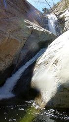
A scenic canyon in the Pinaleno Mountains near Safford, AZ with a good handful of short rappels, waterfalls and slides. Time your trip right in Spring for highest flow when the snow melt is peaking, or in the Fall after wet season runoff and beautiful Fall colors are on the many sycamore and cottonwood trees in the middle and lower parts of the canyon. At certain times of year, the exit may contain a large amount of spider-infested brush making the trip less pleasant.
Trailhead Parking: 32.7001, -109.78830 at elevation 4,336ft
Trail Junction: 32.6978, -109.8125, elevation 5,560ft, stay left do not go right on Round the Mountain trail
Drop In: 32.6845, -109.8116, elevation 5,383ft
First Rappel: 32.68581, -109.81094
Confluence Gibson Creek: 32.68979, -109.80397
Confluence South Canyon: 32.69424, -109.79925
Approach[edit]
Drive[edit]
From Phoenix, drive east on the US60 through the city of Globe, then take US70 to Safford. Turn right (south) onto US 191 in Safford and drive for 7.4 miles, then turn right again onto state route 366 and drive for 3.3 miles to turn right onto forest road 57 (unsigned) to drive for another 3.7 miles to reach Gibson Canyon trailhead. FR 57 is quite rocky near the start, but improves a bit the farther you go. The only other obstacle of consequence is a creek crossing (Marijilda Creek) at about 2.6 miles that at least at the time of this writing was about 4 inches deep and fairly flat. Assuming your vehicle can safely make this crossing, continue straight past the creek, ignoring a right branching road very shortly afterward to drive the remaining 1.1 miles to the trailhead on the left which is signed "57 end" and has mileage posted for Gibson Canyon trail 308.
Hike[edit]
Total approach time will be roughly: 1:45.
From the trailhead, continue west on the road you were driving on for 1/10th mile until the old Jeep road ends and the trail begins to the right. The trail is well worn and generally easy to find your way, though can become overgrown in sections making it difficult to follow. The trail goes west and up the slopes of the mountain to get around the two major drainages you will encounter along the way. The first drainage is South Canyon after 1.3 miles of hiking, follow the trail as it crosses South Canyon slightly down the drainage to the left to continue up through a few switchbacks up the opposite slope. At 1.9 miles you will reach a junction with the Round the Mountain trail, signed with mileage to Frye and Marijilda Creeks, stay left to continue towards Marijilda Creek on the Round the Mountain trail. After 2.15 miles you will reach another trail junction with a broken old trail sign, stay straight (may feel like left) here to continue hiking towards Marijilda Creek. At 2.5 miles you will reach a crossing with Gibson Creek, follow the trail as it goes directly across the creek. At around 3 miles you will reach a more minor unnamed drainage crossing, look left down the drainage for a rock cairn that will lead you to the continuation of the trail on the other side of the drainage. A short ways after this crossing the trail becomes even more thin and difficult to follow, but you are very close to the canyon by now, so if you lose the trail you can simply begin heading down the slopes and gullies that will take you in short order to Marijilda Creek.
Once in the creek bottom proceed left down canyon through the brush and boulders before arriving at the obvious point where the canyon becomes polished rock and flowing water - this is the start of the technical section and is a good time to asses your comfort with the water flow levels. Though the flow was medium on our descent, we found no spots that posed abnormally high dangers from flow levels such as hydraulics.
Descent[edit]
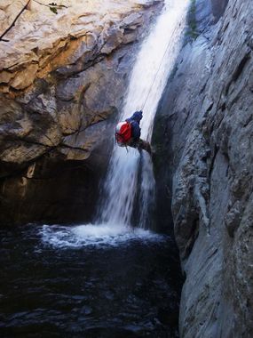
Up to 8 rappels. The first and last were done with retrievables. This canyon could become a classic and would be great to combine with Frye Canyon to make a great weekend.
Some of the drops may be able to be jumped or slid (hence the range in number of rappels) depending on the water flow conditions and your comfort level. If choosing to jump, you will want to send the first person down on rappel - preferably with goggles - to check the depth of water and make sure it is free of dangerous obstacles (branches, boulders) before committing the rest of your party to jumping or sliding.
R1: 30' Tree LDC using retrievable. Careful of V-slot for foot entrapment.
Teacups
R2: 50' Single bolt and hanger RDC.
R3: 15' Cairn LDC. Do not slide as there is a rock under water about 4 feet from the entry point.
R4: 90' Tree, RDC. 40-foot waterfall into shallow pool. Not advisable to slide, or easy climb around on the right.
Jump: 4-foot
R5: 20' Rock pinch LDC.
R6: 50' Tree RDC.
R7: 20' Tree mid-watercourse, or 10-foot hand line RDC.
R8: 10' nuisance drop, used retrievable.
Exit[edit]
Approximately 1 hour of boulder-hopping and mild bush whacking, then leave the creek via a short social trail that leads up to the road / parking area.


