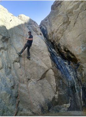
Massacre Canyon
| Rating: | |||||||||||||||||||||||||||||||
|---|---|---|---|---|---|---|---|---|---|---|---|---|---|---|---|---|---|---|---|---|---|---|---|---|---|---|---|---|---|---|---|
| | Difficulty:3B I PG (v3a2 I) Raps:3, max ↨35ft
Red Tape:No permit required Shuttle:None Vehicle:Passenger Rock type:Granite | ||||||||||||||||||||||||||||||
| Location: | |||||||||||||||||||||||||||||||
| Condition Reports: | |||||||||||||||||||||||||||||||
| Best season: | Avoid hot summer days
|
||||||||||||||||||||||||||||||
| Regions: | |||||||||||||||||||||||||||||||
Introduction[edit]
This canyon is currently CLOSED by the Department of Fish and Wildlife.
This is a very brief and short canyon perfect for an afternoon or morning outing to suppress the urge to go canyoneering somewhere else that may take much more time. It is a very easy hike that has been somewhat overran by locals.
Approach[edit]
Park under the Cottonwood tree on the shoulder of Gilman Springs Road on the east or west side of the bridge crossing over the drainage from Massacre Canyon. Proceed to hike up the creek and stay right on each Trail you come to. You will notice a faint Trail across the right side of the canyon that will safely allow you to hike around to the top of the waterfalls. You will notice that after some heavy rains rockfall is common and will have washed away part of the hiking trail with some very careful navigations it is easy to cross over. Once you get to a peak where the trell nearly dissipates you will notice a rock slide area that you hike down about 100 ft that you can find the trail to the right to hike to the canyon bottom.
Descent[edit]
From there proceed down the canyon to the top of the first rappel. There is a semi large Rock on Canyon right about 15 to 20 ft back from waterfall Edge that you can wrap webbing around. It is commonly covered with dirt and mud so you have to dig around the backside of The Rock. Locals that come here typically will take anything that you leave so make sure to bring anchor building material. The repel is about 35 ft but you will need about 50 ft to reach the bottom of the first rappel. This drops you to a small section on top of the second rappel where there is little room to build another anchor so I used a 75 foot rope and a 75 foot pull cord and repeal the first and second as one. There are some old anchors put in the cracks on the first rappel that you can use as an anchor point just be mindful that anything you leave will most likely be removed.
Travel down Canyon for about 1/4mi to the third rappel. There is a small tree DCR that is a good place to practice ghosting. This waterfall it can easily be down climb by the stair like formation on the right side of the water course. But you are here to rappel and ghosting is a fun way to practice on a waterfall that is easy to climb back up in case you made a mistake.
Exit[edit]
Just follow the water course back down to the bridge and walk to your car.
Red tape[edit]
This canyon is currently closed by the Department of Fish and Wildlife.
There has been some reports of break-ins two vehicles parked on the side of the road during evening and night hours from locals
