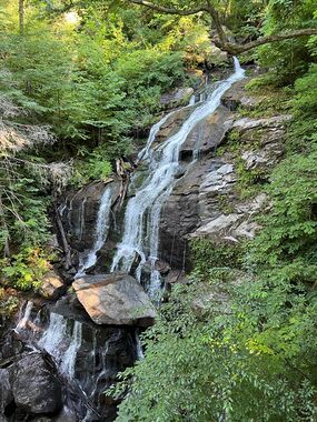
Melrose Falls
| Rating: | |||||||||||||||||||||||||||||||
|---|---|---|---|---|---|---|---|---|---|---|---|---|---|---|---|---|---|---|---|---|---|---|---|---|---|---|---|---|---|---|---|
| | Difficulty:3B I (v3a2 I) Raps:1-2, max ↨200ft
Red Tape:No permit required Shuttle:None Vehicle:Passenger | ||||||||||||||||||||||||||||||
| Start: | |||||||||||||||||||||||||||||||
| Parking: | |||||||||||||||||||||||||||||||
| Condition Reports: | |||||||||||||||||||||||||||||||
| Best season: | Spring to Autumn
|
||||||||||||||||||||||||||||||
| Regions: | |||||||||||||||||||||||||||||||
Introduction[edit]
Easy waterfall rappel near Saluda, NC. Easily done in less than 2 hours. This rappel is mostly slab with a couple short vertical drops. It's super easy and would be a great place to take someone who has never rappelled before. No water flow risk, no swimming required, no wetsuit required. Will get wet up to your knees.
Approach[edit]
Park at the bridge, walk past the gate. Take the trail to the main Falls. Two options from here, first would be to bushwhack to the top of the falls itself. Second option is to take a trail further up which leads to an abandoned railway bridge and enter the creek there. You can downclimb all the way to the top of the falls from there pretty easily, there is also one drop that you could rappel if you want.
Descent[edit]
There is a large tree DCL (down canyon left) at the top of the falls which we used for our anchor and it worked great. I was told after that there are some bolts DCR at the top you can use as well.
Exit[edit]
Return back to the top of the falls to get your rope, and bushwhack back over to the trail (maybe 150 feet of bushwhacking until youre at the trail). I recommend bringing simple ascending gear and just ascending the rope back up to the top, its easier than climbing back up on the dirt. Then take the same trail back to your car.
Red tape[edit]
Beta sites[edit]
Trip reports and media[edit]
Trip report from 2016 indicates the waterfall is 80 ft high. It also contains some description of what the waterfall bypass is like (poison ivy etc).
