Memaloose Creek (Columbia River Gorge)
| Rating: | |||||||||||||||||||||||||||||||
|---|---|---|---|---|---|---|---|---|---|---|---|---|---|---|---|---|---|---|---|---|---|---|---|---|---|---|---|---|---|---|---|
| | Raps:3-5, max ↨50ft
Red Tape:No permit required Shuttle:None Vehicle:Passenger | ||||||||||||||||||||||||||||||
| Location: | |||||||||||||||||||||||||||||||
| Condition Reports: | 3 Mar 2018
"Fun little outing if youre in the area. Little brushy in spots, but not that bad. Beware poison oak. Dont bother if theres no water. |
||||||||||||||||||||||||||||||
| Best season: | Jan-Mar
|
||||||||||||||||||||||||||||||
| Regions: | |||||||||||||||||||||||||||||||
Introduction[edit]
A very short seasonal creek between Mosier and Rowena in the Columbia Gorge. Memaloose is not a high-quality objective and is best to visit very early in the season when everything else is running high and you need your rappel fix. Very mellow. Fine for beginners. Note that this creek only has flow / run-off in the very early season is dry the rest of the year. Going early season is also a good way to evade the poison oak. Do not expect greatness.
It's easy to park at the mouth of the creek (I-84 eastbound only) and check water conditions. Don't bother if there's no water running.
Approach[edit]
Directions[edit]
Take I-84 east of Hood River for 8.2mi to the Memaloose Rest Area (eastbound exit). Park at the far eastern end of the parking lot.
Hike In[edit]
From the east end of the rest area locate a paved trail and follow it east. Note entertaining signs about poison oak and rattlesnakes. At the easternmost point of the paved loop, break off and head east on a faint trail. The trail comes and goes, but generally heads eastward and trends south. You may need to detour to get around occasional thickets of poison oak. Follow through rock meadows about 0.4mi before trending southeast. Reach a small creek (not the one you're looking for) and cross it, heading upstream on the far side. You might intersect an old road grade heading the right direction. Eventually pop out on an actual road that leads into a local rock quarry. Follow the road up to the crest of the hill before breaking off and headin gover to the picturesque top of Memaloose Creek. R1 is immediately downstream.
Descent[edit]
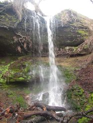
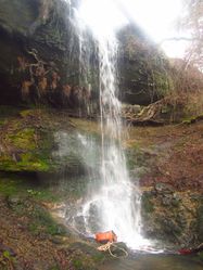
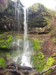
- R1: 25ft. There aren't any good anchors near the lip. Anchored off a tree set some 50ft back. Can bypass DCL.
Notable hazards on R1: 1) Remnants of a barb-wire fence is hanging in the water DCL at the top of the falls. Would be good to get some wire cutters and get that out of there. 2) Loose rocks on the lip.
- R2: Low angle chute to 15ft drop. Downclimb or rappel.
- R3: 6ft drop. Might be downclimbable, but don't slip. There is a small natural arch DCR at the bottom of the falls.
Below R3 the creek enters the trees and becomes a little overgrown.
- R4: 50ft. Anchored off a tree DCR. Need about 90ft of rope to reach the bottom.
- R5: The creek passes over a large rock shelf, then drops 15ft. Probably downclimbable, but don't slip. Anchored off a tree DCR.
At the bottom, pass through a short mossy narrows to a final 6ft step. Downclimb or rappel.
Exit[edit]
You've reached the end when the creek plunges into a culvert underneath I-84.
Climb up the embankment wherever is easiest and pop out on the highway shoulder. If you didn't leave a shuttle car at the mouth of the creek, you'll need to hike west 0.6mi along I-84 back to the rest area. It's possible to thrash your way up the steep slopes DCL of the creek mouth, but this can get you into some sketchy terrain and it's not worth the effort. Walking along the highway is safer.
Red tape[edit]
Memaloose Creek is entirely on public land: mix of Memaloose State Park, Mt. Hood National Forest, and a land trust held by the Friends of the Columbia Gorge. There are some smatterings of private properly west of the creek, so please respect the locals and avoid them.
Beta sites[edit]
Trip reports and media[edit]
Background[edit]
"Memaloose" is the local Chinook jargon and roughly translates "Place of the Dead." It's a somewhat ironic name for a rest area off the highway. The name originates from the island of the same name offshore. The island was one of a number called "Memaloose" and were locations where the local tribes interred their dead. The Army Corps of Engineers exhumed all the human remains during the building of Bonneville Dam and re-interred them in a mass gravesite near The Dalles, OR.


