Middle Fork Kaweah River (Panther Creek Gorge)
| Rating: | |||||||||||||||||||||||||||||||
|---|---|---|---|---|---|---|---|---|---|---|---|---|---|---|---|---|---|---|---|---|---|---|---|---|---|---|---|---|---|---|---|
| | Raps:1-4, max ↨200ft
Red Tape:No permit required Shuttle:None Vehicle:Passenger Rock type:Granite | ||||||||||||||||||||||||||||||
| Location: | |||||||||||||||||||||||||||||||
| Condition Reports: | |||||||||||||||||||||||||||||||
| Best season: | Sept-Oct
|
||||||||||||||||||||||||||||||
| Regions: | |||||||||||||||||||||||||||||||
Introduction[edit]
The Kaweah River area has an abundance of low angle canyons with few rappels, but plentiful jumps, slides, downclimbs, etc. Panther Creek Gorge is the best of all of these, with very impressive solid bedrock gorges, fantastic natural waterslides, and almost a guarantee of some challenging whitewater to negotiate, even late in the season. While there is little in the way of rappelling in this canyon, the swiftwater danger is considerable, particularly at one choke-point in the canyon.
The Middle Fork of the Kaweah River may have the biggest drainage area of anything you would go canyoneering down in the Sierra Nevada. As such, the season is late. In a big snow year, it might never be a good idea to head down.
After a near average snowpack year, on Sept 18, at a flow of 22cfs on the dreamflows guage http://www.dreamflows.com/graphs/day.103.php, we found the flow to be reasonable (My guess is that the flow up in the gorge equated to just over half of the Three Rivers gauge). One spot required a fairly easy, but exposed/sketchy move that would have been difficult to protect, even with bolting. I wouldn't recommend going in if the gauge read over 25cfs, until you familiarize yourself with the canyon.
Also note that this is a rather famous run for kayakers. Be considerate when placing anchors etc. Please note: in July, 2021 a person died while assisting a member of their party from below at the crossing from canyon right to left noted below. Extreme caution must be used in evaluating this section of the canyon.
Approach[edit]
From Three Rivers, head up 198, enter Sequoia National Park and drive up along the Middle Fork. Turn right toward Buckeye Flat Campground, up a narrow twisty paved road, then left on a narrow twisty gravel road to the Middle Fork Trailhead.
From here hike up the Middle Fork trail 3 miles to Panther Creek. This spot is fairly obvious, with a major creek coming in, a nice campsite, and a fairly tall waterfall that drops to your right down into the Middle Fork. Here you could rappel down Panther Creek falls into Panther Creek Gorge (I haven't tried it, but a 200 foot rope should do the trick), or if you'd rather bring less rope (a 120 foot rope should do you for the whole gorge), a scramble approach is just up the trail. Note that during the time of year you would do this canyon, this approach will fill your socks and shoes with nasty pointy seeds. Note that for the waterfall, the rock on top is ridiculously slick and polished, and there has been at least one death from someone slipping off the top.
For the scramble, heading up the trail not too far an obvious little trail splits to the right and only goes 10 feet or so to the top of a cliff and a sort of view into the gorge. Just past that trail, is a less obvious path through the dry grass that cuts steeply down the wooded slope. Eventually it cuts over to a large boulder. Beneath the boulder is a rabbit hole you can crawl through to a fairly easy, but exposed scramble down to the bottom of the gorge below.
Descent[edit]
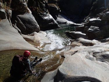
Head downstream! A few slides follow. Some of them are more fun and less bumpy than they look like they might be. The initial gorge is quite pretty, and eventually opens up slightly to a more bouldery section. But don't worry, the best part is yet to come.
Downstream a ways the walls will rise up as you enter a pure bedrock gorge. A small drop leads in, which can be climbed around, followed by a sliding waterfall that hits a wall, with a huge eddy room just upstream. You may be able to jump 25 feet into this room off a ledge on the left (6-7 feet deep when I jumped it) or you can climb up on top of the ridge between the river proper and the room, and rappel off of a tree. You will need to swim across the jet of water shooting out of the waterfall you bypassed, which can be challenging at higher flows.
The gorge beautiful gorge continues downstream. A very high quality slide is found in the midst of the gorge, which starts in a low angled chute, dumps out onto a more open slide, which if you keep right on, will connect easily with a second stage to the same slide. You can walk up for repeat laps on this.
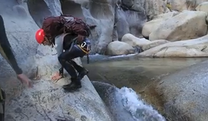
Just downstream of this slide is what we found to be the most dangerous spot. The water moves from right to left across the canyon down a chute and into a pocket on the left with strong hydraulic currents. We found it fairly easy, if a bit unnerving to jump across this water chute. With more water, this would prove more difficult. With bolting there is likely a way this move could be protected (I'm thinking rope swing?), but finding a totally safe way to do it would be challenging.
The water in the hydraulic is on the order of 12-15' deep with no ability to duck out and escape, or use other similar methods. This section could conceivably be confused with a section that would be described similarly further upstream, tricking a party into thinking they were past the danger. In the event a person entered the hydraulic from above or below, it is unlikely they will be reachable with a throw bag. Additionally, if they were, it is likely that multiple people would be required to pull (from below) to extract due to the force of the hydraulic, making rescue unlikely. Rescue attempts with a second person are only likely to generate another victim.
Video, @1:05 https://www.facebook.com/rickinlo/videos/10104320468727933
A couple more fun slides follow just downstream. Past these a right hand bend as the canyon opens slightly affords a view of Moro Rock. A large rock ridge on the right sticks up, and can be climbed down toward a ~30 foot waterfall that drops in from the right. Just north of this rock ridge a social trail leads back up to the Middle Fork, if for some reason you are looking for a way out. If all is well, continue downstream, as there is certainly more fun to be had.
Much of the next section is bouldery and simple. Soon however, the opportunity for a big steep slide comes up where Crescent Creek comes in as a crack from the right. The drop can be easily bypassed on the right. It is a sliding waterfall that shoots down landing just before a big boulder. The line to slide the fall is fairly narrow, and on far river left, but was easy to hit. Different flows may change how well this works.
Further down is another very pretty bedrock gorge. It may require a short rappel to enter this from boulders on the right. The whole thing can be bypassed on the left by following on top of the rock, and climbing a narrow ledge. Just after this narrow ledge is a spot to drop into the gorge and skip the rappel. You will come down a ridge toward where a sliding waterfall smashes into a rock, and just above another drop. You can slide down a fun, dry chute, landing just below the second drop, if you're into the idea, but that approach is probably not for everyone. This gorge ends with a fun slide, that must be done on river right, to avoid dropping into an uncomfortable looking pocket. At normal flows this is very easy to do.
Exit[edit]
Downstream there are more drops to play in, but don't forget that the big granite slab on your right below the last gorge is where your exit is. Just upstream from where Moro Creek comes in on the right is a social trail that heads up into the woods around a few small falls (or dryfalls) in Moro Creek. The trail dumps out onto bedrock where you can climb up Moro Creek, but look out for the trail to head out of the creek to the right again, where it hits the Middle Fork Trail at a switchback. You can turn left and walk shortly back to your car.


