Mill Creek (Stanislaus Tributary)
| Rating: | |||||||||||||||||||||||||||||||
|---|---|---|---|---|---|---|---|---|---|---|---|---|---|---|---|---|---|---|---|---|---|---|---|---|---|---|---|---|---|---|---|
| | Difficulty:3B II (v3a2 II) Raps:4-8, max ↨100ft
Red Tape:No permit required Shuttle:None Vehicle:Passenger | ||||||||||||||||||||||||||||||
| Location: | |||||||||||||||||||||||||||||||
| Condition Reports: | 11 Jul 2021
"The approach is short but VERY prickly (especially for those in the front of the group). When you get to the river, it looks like there may be a trail |
||||||||||||||||||||||||||||||
| Best season: | Whenever
|
||||||||||||||||||||||||||||||
| Regions: | |||||||||||||||||||||||||||||||
Introduction[edit]
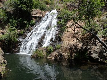
A short canyon off Highway 4. It's not particularly gorged in, and most of the drops are low angle, and blocky, allowing for easy downclimbs. The scenery is nice though, and it's a short trip, perhaps a decent place to introduce someone to canyons? Based of the gauge (which does not live update) it seems that this creek is maintained at around 1.5cfs pretty consistently.
Approach[edit]
Take Hunter Dam Road 1.6 miles off Hwy 4 and find somewhere to park. This should put you just a little ways past a house and some private property. A short bushwhack down the hill will take you to Mill Creek, and you can start down. At times the foliage may include a considerable number of berry bushes with very sharp thorns, so clothing with good coverage is very helpful.
Descent[edit]
The canyon starts with a beautiful riverwalk interspersed with a few (perhaps four?) downclimbs. A bit of team climbing is helpful on the later downclimbs.
About three quarters of the way down the canyon (per the GPS track), the rappels begin. Some of them are pretty fun, none require any real swiftwater technique at the standard flow of 1.5cfs.
- R1: 30'. 2 options: LDC by wrapping a boulder with a crack is totally dry; RDC off a small tree (depending on the line you take you can choose to go in or out of the flow here). The in-flow option has some sharp edges, so creeping the rope is a good idea.
- R2: 100' almost exactly off a boulder LDC, following the split in the waterfall to the left (natural fall line). There may be an option to rig a tree at the top, center canyon, and to descend in the waterfalls and get a little wet. This will likely require more than 100' of rope. The slope of the rappel might make it possible to stop early and downclimb.
- R 2.5 or Downclimb: 30'. Just after R2 there's a crack RDC. Experienced canyoneers will have no problem downclimbing, but beginners may prefer to rappel this. It's possible to exit the canyon at this point by scrambling up the hill DCL.
- R3: 30' - The third rappel is short down from the top of a small waterfall. A tree at the lip of the waterfall provides a good anchor, and options to rappel left through a bit of water or right onto dry rocks.
- R4: 50-120'. The fourth rappel is at a fairly vertical waterfall LDC that pauses at a small pool (50') before continuing down a gentler slope to collect in a large pool (an additional 70'). It's possible to downclimb the 2nd part, but some of the rocks are extremely slippery, so a rappel may be prudent for beginners. A tree on the RDC of the waterfall makes for a good anchor, though there are many other options.
Perhaps the highlight of the canyon is a sharp right turn into a little gorge. Just after that section, you can see the canyon get choked with bushes. This is where we chose to exit.
The slope of the canyon mellows here, but it does drop another 600ft of elevation to the river, with some waterfalls easily seen on satellite imagery. You could choose to continue, but then you'll need to discover your own way out.
Exit[edit]
Make your way up the ridge, keeping an eye out for poison oak, which should be avoidable if you are careful. The way is steep, with occasional exposure and loose rock. Eventually, you will get to a small cliff blocking the ridge, which can be bypassed on the right. Continue back up to the left, and soon after that cliff, you'll come out to the road, and a short walk back up it to your car.
Red tape[edit]
Note that there is private property that extends close to the drop-in point. Signs are posted on the trees. As long as you are close to the end of the trees you should be fine. The rest of the canyon is solidly in USFS land.
Beta sites[edit]
Trip reports and media[edit]
We did this canyon with a team of three (including two first-timers) in July 2018. We used a 200-foot rope, and added a short pull-cord as insurance on the 100-foot rappel. Water noise and blind corners made it difficult to communicate down some of the rappels, which added a little complexity for those learning to rappel, but everything went fine. The canyon was absolutely beautiful, with steady running but unproblematic water flow. The water was very warm (swimming pool temperature), and almost entirely avoidable for those who wanted to stay dry. We did end up spending substantially longer, car to car, than the ~5 hours predicted, and were glad to have started early in the day so that we still had plenty of sunlight for our exit.
