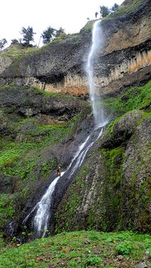
Mist Falls
| Rating: | |||||||||||||||||||||||||||||||
|---|---|---|---|---|---|---|---|---|---|---|---|---|---|---|---|---|---|---|---|---|---|---|---|---|---|---|---|---|---|---|---|
| | Difficulty:3B II X (v6a2 II) Raps:2, max ↨315ft
Red Tape:No permit required Shuttle:None Vehicle:Passenger Rock type:Basalt | ||||||||||||||||||||||||||||||
| Location: | |||||||||||||||||||||||||||||||
| Condition Reports: | 14 Oct 2024
"I updated the beta. The creek bushwhack is solid devils club. R1 is challenging due to the mess of vegetation, fallen trees, branches, loose rocks, an |
||||||||||||||||||||||||||||||
| Best season: | march-may
|
||||||||||||||||||||||||||||||
| Regions: | |||||||||||||||||||||||||||||||
Introduction[edit]
Be aware: this creek was overrun by the Eagle Creek wildfire in September 2017. Please use extreme caution when descending the creek. Between landslides, fallen trees, and loose rocks, this area may be unstable and dangerous for years go come.
While Mist Falls towers at 520ft, it is frequently disregarded due to its proximity to Multnomah Falls and its smaller watershed. The falls features a unique orange-tinted basalt column band that makes the falls more distinct and scenic than the other (but still impressive) seasonal runoffs that plunge off the cliffs of the Columbia River Gorge. Mist Falls is best seen in its entirety from Benson State Park or driving by on I-84. While several waterfall websites list the drops as 220' and 300', we found the rappel lengths to be 290' and 315'.
- Please note that the topo maps for the location of Mist Falls is incorrect. The map displayed on this page shows the correct location of the falls.
- Post-fire, this falls should probably be regarded as an overly dangerous stunt rappel.
Approach[edit]
Spring seems to be the best time to visit as the falls may diminish or dry up entirely during the summer. To get an idea of water flow levels, park at the exit, and hike a few minutes up to take a look.
From the parking lot, take the Wahkeena Falls trail, then turn west to head over towards Angels Rest. Eventually, veer off and bushwhack down into the creek. Long pants, long sleeves, gloves, and garden loppers or snippers are recommended. Bushwhacking to the creek is tall, thick vegetation. Once in the creek, it's heavily overgrown and full of Devil's Club. Taking the depicted shortcut will drop you into the creek close to the first rappel. This shortcut route has not been confirmed, but may reduce creek walking through the Devil's Club nightmare.
Descent[edit]
- R1: 290'. This is not your typical rappel and should be taken seriously. The waterfall pour over is an extension of the creek bushwhack. It's a mess of downed trees, branches, brush, loose rocks, and more loose rocks. R1 is set up as a hanging anchor: a 40ft cord from a log spanning the creek to protect from sticking the rope in the woody mess at the top. It may be best to treat it as a rebelay - i.e., rappelling to reach it. The top half of the pitch is loose rocks, and it's impossible to clean them all. You will experience falling rocks while on rappel.
- R2: 315'. Webbing on a tree on a ledge RDC. Look out below as there are occasional falling rocks here too.
You will not be able to see or hear the rappeler on either drop. Radios are very helpful for communication.
Exit[edit]
Hike back down the scree-sloped trail and follow the Historic Highway east back to your car.
Red tape[edit]
None.
Beta sites[edit]
 Super Amazing Map : Mist Falls
Trip reports and media[edit]
Background[edit]
This canyon was first descended by Tiffanie Lin, Luca Chiarabini, Michelle Nilles, and Erik Bernhoft on March 28, 2015.
