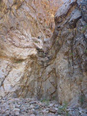
Moonlight Canyon (Upper)
| Rating: | |||||||||||||||||||||||||||||||
|---|---|---|---|---|---|---|---|---|---|---|---|---|---|---|---|---|---|---|---|---|---|---|---|---|---|---|---|---|---|---|---|
| | Difficulty:3A IV (v3a1 IV) Raps:6, max ↨100ft
Red Tape:No permit required Shuttle: | ||||||||||||||||||||||||||||||
| Location: | |||||||||||||||||||||||||||||||
| Condition Reports: | |||||||||||||||||||||||||||||||
| Best season: | Nov-Mar (avg for this region)
|
||||||||||||||||||||||||||||||
| Regions: | |||||||||||||||||||||||||||||||
Introduction[edit]
ONE OF THE FEW CANYONS THAT I STARTED FROM THE TOP AND WENT DOWN, AND THEN HAD TO FIND A WAY TO GET BACK UP AGAIN
Approach[edit]
Approach is from Phinney Canyon Road (21 miles, 4x4 high clearance).
From Beatty, Nevada, drive north on US95 about 11.8 miles. Once you pass a communications tower on the west side of the road, take the second left onto an unmarked dirt road through a fence gate.
You will eventually pass through another fence and enter Death Valley National Park.
At about 12.2 miles, take the right fork. (The left goes to Strozzi Ranch.)
The last mile of the road is much rougher than the earlier part. The road ends at a pass, which is trailhead for Grapevine Peak and Wahguyhe Peak. Park here.
Follow the old road down into Moonlight Canyon. After about a mile it will disappear and the route gets very brushy (long pants recommended).
If you are planning to return to Phinney Canyon, make sure you pay attention to your return route.
Descent[edit]
The canyon has 6 rappels, all less than 100 feet. No significant down climbs.
Exit[edit]
Red tape[edit]
Beta sites[edit]
 Super Amazing Map : Moonlight Canyon
Trip reports and media[edit]
Background[edit]
The canyon was named by Jim Unruh, a former park ranger (in Death Valley early 1970s to 1984). He approached from the top and returned back to Phinney, but it took them . . .until moonlight.
Originally explored by Scott Swaney on 2014-04-19 under the identifier "G 1.". See more at Scott Swaney's Death Valley Canyoneering Exploration.
