Mosaic Canyon (Southwest Fork)
Jump to navigation
Jump to search
| Rating: | |||||||||||||||||||||||||||||||
|---|---|---|---|---|---|---|---|---|---|---|---|---|---|---|---|---|---|---|---|---|---|---|---|---|---|---|---|---|---|---|---|
| | Difficulty:3A IV (v3a1 IV) Raps:8, max ↨220ft
Red Tape:No permit required Shuttle: | ||||||||||||||||||||||||||||||
| Location: | |||||||||||||||||||||||||||||||
| Condition Reports: | |||||||||||||||||||||||||||||||
| Best season: | Nov-Mar (avg for this region)
|
||||||||||||||||||||||||||||||
| Regions: | |||||||||||||||||||||||||||||||
Introduction[edit]
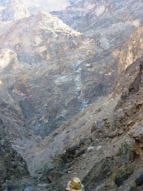
JOINS SSW FORK DONE EARLIER AND CHANGED THE LOWER SECTION OF ROUTE. HAS A 440' WALL THAT WE BROKE INTO TWO 220' RAPPELS. NOTE PHOTO SHOWS THIS 440' DROP IN THE LOWER PORTION OF THE CANYON - ANOTHER VERY BIG DROP SECTION ABOVE ALSO
Approach[edit]
Descent[edit]
Exit[edit]
Red tape[edit]
Beta sites[edit]
 Super Amazing Map : Mosaic Canyon - SW Fork
Trip reports and media[edit]
TWO REPORTS FOR THIS CANYON
- https://www.facebook.com/scott.swaney/media_set?set=a.10151558331547930.1073741833.668617929&type=3
- https://www.facebook.com/scott.swaney/media_set?set=a.10150556742807930.444337.668617929&type=1
Background[edit]
Originally explored by Scott Swaney on 2013-03-16 under the identifier "M 2.". See more at Scott Swaney's Death Valley Canyoneering Exploration.
