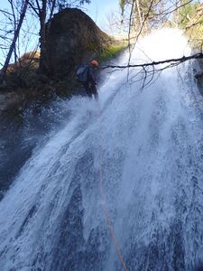
Munra Creek
| Rating: | |||||||||||||||||||||||||||||||
|---|---|---|---|---|---|---|---|---|---|---|---|---|---|---|---|---|---|---|---|---|---|---|---|---|---|---|---|---|---|---|---|
| | Raps:7, max ↨130ft
Red Tape:No permit required Shuttle:Optional 2min Vehicle:Passenger | ||||||||||||||||||||||||||||||
| Start: | |||||||||||||||||||||||||||||||
| Parking: | |||||||||||||||||||||||||||||||
| Shuttle: | |||||||||||||||||||||||||||||||
| Condition Reports: | 6 Dec 2025
"There is a lot of new down trees in the creek and the blackberry bushes have firmly re-asserted control. Not as good of a creek as it was 9 months ago |
||||||||||||||||||||||||||||||
| Best season: | Mar-June
|
||||||||||||||||||||||||||||||
| Regions: | |||||||||||||||||||||||||||||||
Introduction[edit]
Be aware: Munra Creek was overrun by the Eagle Creek wildfire in Sept 2017. It is not what it was. Be prepared for brush, briars, loose rocks, and a lot of woody debris in the creek. Access, however, is great, and the falls are still fun. Today, Munra is best run in the winter and early spring for less vegetation and more water. Later, water levels subside, and it's a reasonable beginner-friendly canyon well into July.
Munra Creek is a lesser tributary of Tanner Creek and sports seven rappels; three of them over 100ft high. With a small, relatively low elevation watershed (0.7mi^2), it's a good choice early in the season. Waterflow is best in the spring and reduces substantially heading into summer.
Best Practices[edit]
Please use anchors in or adjacent to the watercourse as much as possible. Climbing to trees higher on the sides is attractive, but risks trampling vegetation and eroding the banks. Riparian environments in the Pacific NW are extremely fragile. Munra has been the site of several rescues in the past. Don't be one of them.
- Teaching people to rappel for the first time in an aquatic canyon is not a good plan. It's much safer to become fully proficient with rappel devices outside the canyon in a safe dry environment.
- Wrapping the rope around trees for a two strand rappel is efficient, but is not good for the tree when you go to pull your rope. Friction damage around the back of the tree cuts into the bark. Done too many times by too many people and the tree will become girdled and eventually die. It's often kinder to the tree to set an anchor (or use a retrievable system).
- Beginners "leading" beginners is a common cause of accidents in canyoneering. Enthusiasm is not a substitute for training by a qualified instructor.
Approach[edit]
Parking / Shuttle[edit]
From I-84, take exit 40. South of the highway, the road splits: the right fork leading to the Wahclella Falls Trailhead, and left up and over the hill to the Tooth Rock Trailhead. You can park at either one. Teams will usually hike (or shuttle) between the two. (See also Red Tape below.)
- WARNING: This area is extremely popular and high risk for car break-ins. Do not leave anything valuable (or anything that looks valuable - ex: packs, bags, purses, etc.) visible in your car.
Hike[edit]
From the Tooth Rock trailhead, walk back up the hill to the water tower where you'll find Forest Road 777 (gated). Follow FR 777 upward for 2mi. Since the fire, teams have been dropping directly off the road to the top of R1. A steep user trail is starting to form which was marked with tape (not obvious) as of June 2025.
- Historically, teams continued another +0.2mi to a sharp right bend where the road crosses Munra Creek, and descend from there. Be prepared for some serious bushwhacking going this way.
Descent[edit]
The hiking between rappels is still a bit brushy post-fire. If folks visiting brings some clippers and do a little tending, hopefully the route will stay open and gradually improve over time.
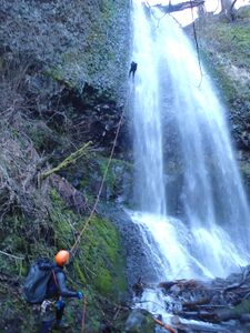
- R1: 125ft from large tree high DCR. Unfortunately, the rappel line is mostly dry, but it's the best option for anchoring given the large, yet mobile, old-growth log occupying the center of the creek right above the falls. (When this log eventually goes over the brink, there might be some better options for staying in the flow. Until then...) Also, beware loose rocks atop the pitch.
Continue downstream about 500ft.
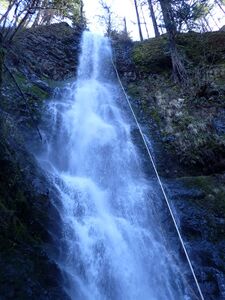
- R2: 130ft from tree DCL. Again, beware rockfall. At the bottom, it's good to move well back from the base of the pitch.
Continue downstream about 500ft. Along the way, cross an old rock slide. In low water, the creek may vanish underground here for a stretch.
- R3: 80ft from unlinked bolts DCR about 20ft back from the edge. The line of the rappel will take you through the flow DCR to DCL.
- R4: 30ft dry rappel from log DCL. Climb down across the logjam mess at the bottom, and scoot your way across the big old growth log.
- R5: 50ft from log DCR. Pull is best from DCL at the bottom to avoid snagging your rope on a rootball.
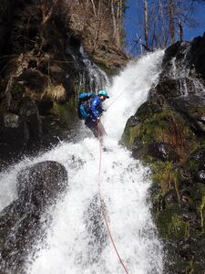
- R6: 80ft from tree DCR about 20ft back from the edge. Rappel is dry at first, but soon enters the flow. Two-tier drop with a pocket you can stem over with some fancy footwork. Look for a neat spring fountaining out of the DCR wall of the canyon here.
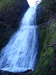
- R7: Munra Falls: 130ft from tree set well back DCR. Beware throwing your rope or rope bag down the pitch. The Wahclella Fall trail crosses the creek on a bridge at the bottom and throwing ropes may endanger hikers. Also beware knocking down rocks. You will likely have an audience on this rappel.
Exit[edit]
From the bridge, follow the trail north to the Wahclella Falls trailhead (5min). If you parked at Tooth Rock, the bike trail alongside I-84 is less strenuous than walking up and over the hill.
Red tape[edit]
A NW Forest Pass is required to park at the Wahclella Falls, but not at the Tooth Rock Trailhead as of June 2025.
Wahchella Falls is a major tourist draw in the Columbia Gorge. Most weekends you will find the trail crowded with visitors. Be aware that canyoning is less well-known in this area, and, sometimes, hikers may react inappropriately to canyoning activities, leading to degraded relations with land managers. Do your best to make a good impression.
Beta sites[edit]
 CanyoneeringNorthwest.com (archive.org) : Munra Creek
 RoadTripRyan.com : Munra Creek
 Super Amazing Map : Murna Creek
Trip reports and media[edit]
 Karl Helser's NW Adventures : Munra Creek Canyoneer 4-22-17
Background[edit]
Munra has been descended at least once in the dead of winter when it was entirely frozen. Bring your crampons.


