Nacimiento del Rio Choy
| Rating: | |||||||||||||||||||||||||||||||
|---|---|---|---|---|---|---|---|---|---|---|---|---|---|---|---|---|---|---|---|---|---|---|---|---|---|---|---|---|---|---|---|
| | Raps:1-2, max ↨250ft
Red Tape: Shuttle: | ||||||||||||||||||||||||||||||
| Location: | |||||||||||||||||||||||||||||||
| Condition Reports: | 29 Dec 2015
"We intentionally short-rigged the drop, as we often do, and rappelled off into the resurgence. There are plenty of opportunities to jump into the wate |
||||||||||||||||||||||||||||||
| Best season: | Nov-Mar (avg for this region)
|
||||||||||||||||||||||||||||||
| Regions: | |||||||||||||||||||||||||||||||
Introduction[edit]
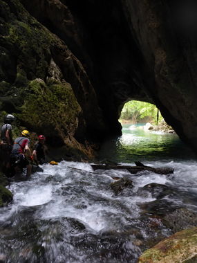
The resurgence of the Choy is a beautiful swimming hole popular among locals and cavers alike. With crystal clear blue water and impressive cliffs around, this is great cave and fine bathing spot too. The road to access the cave is gated and open only occasionally.
It looks like the place, which was abandoned for many years, was renovated in 2020 and is renamed as "El Nacimiento de Tamuín". One of the reviews says that lifejackets are mandatory for swimming here. Therefore you may want to park at the "Parking Alt" location and hike in along the railroad tracks, so that you can set up the rope and do this activity without them telling you 'no' at the bottom. You will still swim out past the developed area, but you've already set up the rope at this point and would hike back up the hillside to your group. Not sure what the reaction of the new owners would be when they see your group.
Approach[edit]
A gated dirt road leads to a parking lot with a picnic area right below the spring and next to an enormous cave entrance (the resurgence of the Rio Choy). Hike up the cliffs following use trails until you reach the railroad on the north side of the bridge. Cross the bridge and follow the stone steps on the right for a short distance to the upper entrance of the cave.
Alternatively it's also possible to park near the railroad and hike along the rails all the way to the bridge. This is the preferred route if the gate for the dirt road is closed, as it avoids having to scramble up and down 300ft cliffs carrying heavy equipment.
Descent[edit]
The descent involves mainly one 108m rappel that descends right into the spring and then float out the cave to the resurgence. An extraordinary experience. The route is bolted at the top and in the middle, which can be useful if using shorter ropes. Exploring the cave requires some practice and care, as a side branch with a bat colony is said to be histoplasmosis infected.
The rappel ends in a peaceful pool, but depending on the season, you may have to cross some rapids floating out of the cave. Although they may look scary, they are shallow and not too difficult to cross.
Exit[edit]
You resurface at the resurgence near the picnic area.
Red tape[edit]
To access the cave requires to drive on a private road that is often open only during tourist season and mostly on weekends. If you find it closed you can opt to hike 2 extra miles on the road in order to reach the cave, carrying all the technical gear and the rope with you.
Beta sites[edit]
- http://www.amcs-pubs.org/maps/1818.pdf Cave Map
- http://www.amcs-pubs.org/maps/1906.pdf Cave Map
- http://www.showcaves.com/english/mx/springs/RioChoy.html
