Nash Creek Canyoneering Canyoning Caving
|
| Rating: |
Log in to rateLog in to rateLog in to rateLog in to rateLog in to rate 2.0 (1 rating) |
|
|
| |
Raps:6-8, max ↨70ft | Overall: | 2-3h | ⟷0.7mi |
|---|
| 0min | | ↑0ft | | 2-3h | ⟷0.7mi | ↑1100ft | | 0min | | ↑0ft |
No Shuttle:Required 15 min |
|---|
| Location: |
|
|---|
| |
|---|
| Condition Reports: |
7 Mar 2020
"First descent on a dreary winter day where other options were limited. A few of us were testing out new drysuits (not so ideal with the all the devil
(log in to submit report)
|
|---|
Weather: |
|
|---|
| Best season: |
Winter & Spring | winter | | spring | | summer | | fall |
|---|
| Dec | Jan | Feb | | Mar | Apr | May | | Jun | Jul | Aug | | Sep | Oct | Nov |
|
| Regions: |
|
46.4339, -121.9410https://ropewiki.com/images/a/a4/Nash_Creek.kmltopo
GPS data automatically extracted from [], please visit their site for more detailed information.
Automatic GPS data extraction NOT allowed, please visit [] to download GPX.
(log in to submit reference picture)
| Welcome! Canyons in the Pacific Northwest can be different from those you might be used to. Be ready for unlinked bolts, retrievable traverse lines, and challenging aquatic environments. For more on local practices, and the best way to get started in the region, check out the WCC Safety page.
- Unlinked Bolts - groups should be comfortable rigging unlinked bolts, either temporarily linking them for all but the last person, or using a passive redundancy method. Most importantly, if you find two bolts side by side that are unlinked, do not add webbing to them. Linking bolts designed to be unlinked will likely cause damage during seasonal floods.
- Traverse Lines - many canyons are rigged to allow traverse line access to an exposed anchor station. This should be done using self-belay or team belay techniques. Do not leave fixed lines in the canyons.
- Challenging Environments - the highly aquatic nature of PNW canyons can surprise many. Cold temperatures, slippery rocks, loud waterfalls, and strong currents all lead to unexpected problems. Do not underestimate the need for strong team work and technical proficiency. Belays are frequently not possible. Unattended gear will sink or float away. Sliding and jumping is the cause of most major injuries, so it's critical to effectively communicating water depth & submerged hazards.
|
Introduction
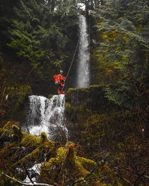
Nash Creek is a small tributary of the Cispus River in the Gifford Pinchot National Forest. Its usually low flow and easy access lends itself best to off-season descents. The creek itself is choked with logs, brush, and copious amounts of devil’s club, though the easy access/exit and nice waterfalls give it a few redeeming qualities. The creek is fairly open and escape/bypasses are possible in most places.
Approach
From the bottom shuttle point where the creek flows beneath the road (46.4339, -121.9410), drive east along forest road 76 for 1.15 miles and take a right onto forest road 77. Follow the road up the hillside for about 3 miles to where the road crosses the creek (46.4248, -121.9403). Park and suit up at the road.
Descent
Drop-in directly where the creek crosses the road, or cut into the forest a bit further down to avoid some of the initial canyon debris.
The canyon features 6-8 rappels up to 70’. Trees and log anchors are plentiful.
Exit
Red tape
Beta sites
Trip reports and media
Background
This canyon was first descended on March 7th, 2020 by Doug Hecker, Haruka-James Clay Lipscomb, Barry Specht, Tom Cross, & Jake Huddleston.
