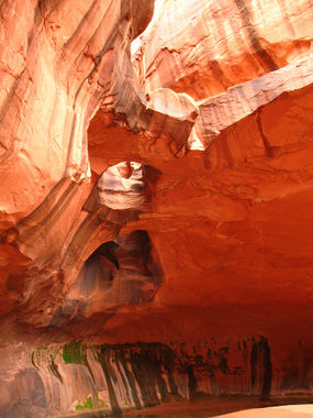
Neon Canyon
| Rating: | |||||||||||||||||||||||||||||||
|---|---|---|---|---|---|---|---|---|---|---|---|---|---|---|---|---|---|---|---|---|---|---|---|---|---|---|---|---|---|---|---|
| | Difficulty:3B IV (v3a2 IV) Raps:5, max ↨83ft
Red Tape:No permit required Shuttle:None Vehicle:High Clearance | ||||||||||||||||||||||||||||||
| Location: | |||||||||||||||||||||||||||||||
| Condition Reports: | |||||||||||||||||||||||||||||||
| Best season: | Spring; Summer; Fall
|
||||||||||||||||||||||||||||||
| Regions: | |||||||||||||||||||||||||||||||
Introduction[edit]
Approach[edit]
Drive: "Hole in the Rock Road": The ~20 mile drive on is on dirt and can puncture tires. It is nice to have a vehicle with good tires + real extra wheel + a plan on dealing with a flat tire. The turn to Egypt Rd is rough with a few wash sections to drive over. The section mile is extremely rugged with spots of gravel & dips that needs high clearance. There will be a lot of cars that park before the rugged section and most people just walk that section.
From the parking area, head down the slick rock slope. Look back and identify the mountains in the distance as the points to keep track of when coming back. Coming back in the darkness will be a challenge so be aware of the ranges where the vehicle is parked.
Approach option #1: via Fence Canyon. The initial portions are in the sand and slick rock. The route goes through the Fence Canyon trees toward the Escalante River. There will be several crossings of the river to navigate and flow should be considered. When it is hot during the day, the shade from the trees and river is nice.
Approach option #2: the "bee-line" shortcut route goes direct and is exposed to the sun.
At the junction of Neon Canyon & the Escalante river is a nice location to rest under the trees with views of the river and the walls of Neon Canyon. Many hikers will come this way to see the Golden Cathedral so be aware of this when setting up rope for the rappel through the roof of the Golden Cathedral.
After the junction: start into the canyon towards the Golden Cathedral. As you leave the area with the large trees, the walls of the canyon start to go up high. As the canyon makes a left turn (left up canon), there will be a marker point to start ascending the slick rock up to the ridge. During out visit, there was a cairn marking this turn up above.
Descent[edit]
Exit[edit]
Red tape[edit]
Beta sites[edit]
 Chris Brennen's Adventure Hikes (Southwest) : Neon Canyon
 RoadTripRyan.com : Neon Canyon
 Climb-Utah.com : Neon Canyon
 CanyoneeringUSA.com : Neon; Fence & Ringtail Canyons
 CanyonChronicles.com : Neon Canyon
 Super Amazing Map : Neon Canyon
 AmericanSouthwest.net : Neon Canyon
Trip reports and media[edit]
 Dennis Turville on Canyon Tales : Edge of the Earth Canyon (aka Neon Canyon), October 22, 1977
 John Schwieder on Canyon Tales : Close Call in Neon's Keeper, May 2003
 Stefan Folias on Canyon Tales : Escalante Flood and Neon Canyon, October 2006
 Mark Rosen on Canyon Tales : Neon's Keeper Descended, May 2008
- https://www.stavislost.com/hikes/trail/neon-canyon-and-golden-cathedral
- http://adamhaydock.blogspot.com/2013/05/ringtail-neon-canyons-escalante.html
 Candition.com : Neon
 Wikiloc.com : Neón Canyon - Escalante National Monument
- Jeff Guest, Beta Video, 2014-08-30
 YouTube.com : Richard Pattison, Neon Canyon - The Edge of the Earth
Background[edit]
This canyon was named Edge of the Earth Canyon or EOE on the first descent by Mike Bogart, Janice Hansen, & Dennis Turville on October 22, 1977 [1][2]
