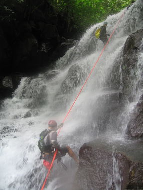
Nonequito Canyon
| Rating: | ||||||||||||||||
|---|---|---|---|---|---|---|---|---|---|---|---|---|---|---|---|---|
| | Raps:4-7, max ↨56ft
Red Tape:No permit required Shuttle: Vehicle:Passenger | |||||||||||||||
| Location: | ||||||||||||||||
| Condition Reports: | 20 Feb 2024
"Flow was fairly low but still enjoyable. We did not locate any established anchors and did not leave any behind. Locating the canyon via the dense jun |
|||||||||||||||
| Best season: | ||||||||||||||||
| Regions: | ||||||||||||||||
Introduction[edit]
One of the better canyons in the region, still wild and unimproved.
Approach[edit]
To access the trailhead, drive through Pejibaye, crossing the bridge over Río Pejibaye, heading toward La Marta reserve. Before reaching the reserve, take a left turn off the paved road and head past some farms. Find the right hand turn through sugar cane fields and drive to the Rio Gato river. You can make it to this point with a passenger vehicle, but if you have high clearance and the water is low enough you can drive across the river and a bit further on to the Parking 4WD on the map.
From here, start hiking up the road that becomes quite overgrown. At a certain point you will reach a T intersection with another trail -- turn right and head uphill along the ridge, eventually entering a dense jungle. At 3100' elevation you'll see a prominent washout on the left of the social trail -- this is a good point to drop about 100' down to the stream.
Descent[edit]
Many of the drops can be downclimbed or avoided with a maximum of about 7 you could rap. Two of the pitches had bolted anchors whilst the majority use trees - actually you could use trees for all of them. You can get away with using about 33m of rope.
There are escapes almost everywhere - it's a classic Costa Rica cañón: nice waterfalls, but not really any deep constrictions.
Note also that the watercourse is incredibly slick.
Exit[edit]
From the ending of the canyon when you reach the sugar cane fields again on your left, climb out of the river on the left and walk through the fields a few minutes to reach the 4WD parking spot, where either your vehicle is or if you didn't drive across Rio Gato, follow the road back to your car.
Red tape[edit]
Beta sites[edit]
