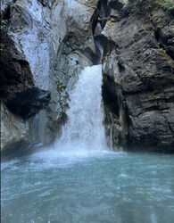
North Fork Tieton River
| Rating: | |||||||||||||||||||||||||||||||
|---|---|---|---|---|---|---|---|---|---|---|---|---|---|---|---|---|---|---|---|---|---|---|---|---|---|---|---|---|---|---|---|
| | Raps:13, max ↨90ft
Red Tape:No permit required Shuttle:None Vehicle:Passenger Rock type:Basalt | ||||||||||||||||||||||||||||||
| Start: | |||||||||||||||||||||||||||||||
| Parking: | |||||||||||||||||||||||||||||||
| Condition Reports: | 30 Sep 2023
"A memorable trip with some special challenges. We ran this canyon at approximately 20% higher flow than normal/moderate conditions. The hydraulic haza |
||||||||||||||||||||||||||||||
| Best season: | Sep-Oct
|
||||||||||||||||||||||||||||||
| Regions: | |||||||||||||||||||||||||||||||
Introduction[edit]
The North Fork Tieton River is an advanced aquatic canyon in a remote area of Goat Rocks Wilderness. Deep, dark, and ice cold, this canyon is stunningly beautiful and funnels much of the water from the east side of Goat Rocks, fed primarily by the McCall Glacier and surrounding snow fields. While the McCall is not a large glacier, the river runs high most of the year. September is typically the earliest this canyon is feasible, best paired with a cool, dry spell to minimize the melting water coming off of the glacier, and no recent rain.
While the canyon itself is overall very short, it is extremely cold and unforgiving and should only be attempted by experienced groups. Drysuits are strongly recommended. The latter half of the canyon is committing and narrow with no exit points. Hazards include trap pools, rappelling in high flow, extremely cold water, pushy pourovers, slippery rock, murky water where checking pool depth is difficult, and waiting in ice cold pools to rappel due to lack of space to climb out of the pools. It is not recommended to exceed 6 team members as larger groups require more waiting time in the cold.
If you think your group may be the first of the season, you could be stranded without an emergency bolt kit. This canyon sees extremely high floods throughout the year, and some anchors have already shown significant damage each season.
At 8.3 miles round trip including the canyon, this is a very long day. The approach and exit are overall straightforward, but navigation on the old trail can be difficult, particularly if exiting in the dark, which is likely for most groups (bring headlamps!). A very early start is recommended. An average group will take 10-12 hours round trip to complete this canyon in normal conditions.
Approach[edit]
Park at the Scatter Creek NAC trailhead (46.57644, -121.35793). You will need a NW Forest Pass to park here. There are several primitive campsites at the trailhead for those wanting to camp before and/or after the canyon.
From the trailhead, follow the main trail for 0.2 miles, taking a left at the first obvious fork in the trail. Soon after, cut right off of the main trail and look for a faint footpath among the many fallen trees. Eventually, the old abandoned trail will become more obvious as it skirts along the bottom of the hillside. The old trail is sometimes hard to follow as it was mostly forgotten before the Miriam Creek Fire in 2018. It is now becoming overgrown with wild raspberry, brambles, and plenty of dead fall to hop and scoot over. Keep an eye out for saw cut logs and random hikers tape that folks have left. You will follow this old trail the majority of the approach to the canyon, with some minor ups and downs close to 3,400 FE until the second to last drainage. Towards the end of the You will gradually climb up until you reach 4,100 where you will drop in to the canyon. It is prudent to track your approach using the track on this page to help guide your approach and exit. Be sure to bring a headlamp as many groups finish the exit in the dark.
Descent[edit]
DCR = Down Canyon Right
DCL = Down Canyon Left
R0: From the suit up area, rappel 100' from a log from the rim of the canyon into the creek. Be careful of loose rock.
Downclimb/creekwalk for 5 minutes to reach the first rappel.
R1: 35' from unlinked bolts located on the front of the larger boulder in the middle of the creek
R2: 30' from unlinked bolts DCR
R3: 25' from a single bolt up high DCL into a narrow corridor
Last Possible Exit: After R3, there is a potential exit scramble up a steep, chossy slope DCL. After R4, the canyon becomes deep and narrow with more significant hydraulic hazards, and no exit options until the end of the canyon.
R4: 25' from a log in the middle of the creek into a boil. Swimming behind the waterfall has worked well here.
R5: 12' from a rock pinch DCR. Immediately swim to the lip of the pool DCR to access the R6 anchor. There is a pourover here that can be tricky to navigate in high flow. Use caution.
R6: 12' from unlinked bolts DCR. As of 2023, one of the bolts is severely damaged from floods. The pool below this rappel is a trap pool and can be a challenge to swim out of, or retrieve stuck packs/bags that have been thrown. Be prepared to swim aggressively.
R7: 10' from a single bolt DCR. This drop has also been downclimbed and jumped.
R8: 15' from a single bolt on a ledge DCL
R9: 15' from a single bolt on a ledge DCL. This drop has been jumped from the ledge.
Directly after R9, there is a short jump from a chockstone in the middle of the creek.
R10: 50' from unlinked bolts DCR. These bolts are somewhat exposed. This rappel takes you down around the corner out of sight into the deepest part of the canyon. Use caution navigating the hydraulic and possible undercut at the bottom of this rappel.
R11: The R11 chute sequence is the crux of the canyon. It is very narrow and constricted, and is difficult or impossible to navigate in high flow. Traverse 25' from unlinked bolts DCR to another pair of unlinked bolts DCR. Rappel 10'. This drop has also been jumped. In 2023, the flow was too high to navigate the chute. A boulder in the chute used to reach the bolts had also been washed away, making the bolts difficult to reach. The group was able to scramble up to a ledge DCR and place a single bolt, which allows access to the primary bolts from above. Another single bolt was placed several further feet out away from the primary bolts to avoid rappelling in high flight. In these conditions, this is a very technical sequence.
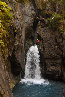
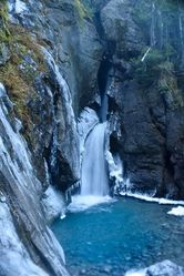
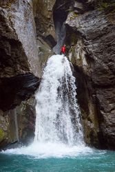
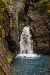
R12: This is the final technical sequence, a spectacular multi-stage rappel through the narrow North Tieton Falls. Traverse 25' from two unlinked bolts DCL to a 90' rappel DCL from two unlinked bolts. Rappel into the hanging pool and swim on rope to the pourover. Beware of getting stuck on a log jammed in the narrow chute. Continue down the second stage. DCL seems to be the easiest way down the second stage of the rappel.
Enjoy the spectacular view of the falls after the final rappel. Change out of your drysuits/wetsuits here, or keep them on for another 25 minutes while you cross the river several times up to knee deep before exiting the river gravels.
Exit[edit]
You will walk the river bed for a good while until you reach the creek confluence where you started climbing up towards the approach. You will attempt to follow the same path. In 4 miles you will reach your vehicles. Bring lights that are waterproof as you’ll likely finish in the dark.
Red tape[edit]
You will need a self-issued wilderness permit, available for free at the trailhead, to access this canyon.
A Northwest Forest Pass is needed to park at the trailhead.
Beta sites[edit]
Trip reports and media[edit]
https://m.youtube.com/watch?v=pUzy14frK8Y
Background[edit]
First full descent by Kevin Steffa, Jake Huddleston, Haruka James Clay Lipscomb, and Ryan Ernst in Nov 2019. 2nd Descent in October 2021 to further establish route.
While discussing how to best close out the 2019 season, Ryan Ernst tossed out NF Tieton to the team and so we went to scope it out in October 2019. We reached the bottom drop late in the day and realized that it wasn’t in the cards. We returned a month later with a better route which enabled us to make it happen. The sub-freezing temperatures in November resulted in very challenging conditions. The team ultimately made it out safe and learned a lot from the experience.
