Olancha Creek
| Rating: | |||||||||||||||||||||||||||||||
|---|---|---|---|---|---|---|---|---|---|---|---|---|---|---|---|---|---|---|---|---|---|---|---|---|---|---|---|---|---|---|---|
| | Raps:4-6, max ↨100ft
Red Tape:No permit required Shuttle:None Vehicle:High Clearance Rock type:Granite | ||||||||||||||||||||||||||||||
| Location: | |||||||||||||||||||||||||||||||
| Condition Reports: | 4 May 2019
"3.5 star canyon, 1 star approach. Strong flow on raps, and 2 slides! Almost too warm to tolerate the approach, and almost too much flow to enjoy all t |
||||||||||||||||||||||||||||||
| Best season: | Mar-May
|
||||||||||||||||||||||||||||||
| Regions: | |||||||||||||||||||||||||||||||
Introduction[edit]
Olancha Creek is located on the east side of the Sierra. While like other east side canyons, it is a bit brushy, the bushwhacking is not bad at all, and several fun rappels and slides make the canyon well worth it.
Anchors are mostly off of trees, except the large rappel, which is bolted DCL. The final rappel is short, but the trees for anchors are a bit on the smaller side.
Approach[edit]
Turn west off of 395 onto Fall Rd in the small town of Olancha. Cross the canal, and head right up a rocky road (do-able in a Subaru, probably not anything less. You could park at the bottom and walk from here without adding too much effort though.) This road ends on a powerline road. Turn right, and find parking on the left just before the road crosses Olancha Creek. You can check the flows here too.
If you look from here up at the canyon Olancha Creek flows out of, coming up from the right you should see a redish colored area that is significantly less steep (sort of a shoulder on the hill side). This is where you will traverse in toward the canyon. Hike up the alluvial fan toward the mountains, keeping an eye out for a good place to cross the creek. Then at the base, climb steeply up until you hit the gentler slope at 6000ft elevation, crossing between some rocky outcrops.
Traverse in toward the canyon over a tiny pass, and descend a steep, loose gully a good ways down to the creek.
Descent[edit]
Heading downstream you soon encounter some bypassable waterfalls in the first gorge. As the gorge narrows, you'll come to a low angled slide that is somewhat trickier to avoid. This is a good spot to suit up, because this slide (in our experience) is good to go! The next drop can be rappelled or downclimbed to the right.
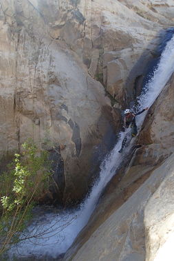
The first gorge ends, and you will have to walk for a good ways. A small path up through some sage brush takes you around the thick willows. Soon you'll come to a series of three rappels. The first is simple. The second rappel which seemed specifically designed to smash you with the entire flow, has been bolted down canyon left, at a spot which will allow you to avoid the majority of the flow if you desire. The third rappel, you will need to cross the flow (start down canyon left, down to a ledge, press yourself against the wall as much as possible, and step/swing to your right/down canyon left, then rappel on).
Soon after these rappels, the canyon enters a short slot. A careful rappel from the right side of the canyon keeps you out of a crevice down to the left. This can be anchored from small willows, or from some rocks way up above you past a large boulder. The second drop you can see exiting this slot is a potential slide, but as of May 2021, is filled in with sand.
Downstream from here after working your way through some willows, you'll come to the final drop. The water used to be ~7-8 feet deep, providing a very fun slide. As of May 2021, it is also filled in with sand.
Exit[edit]
Just below this slide you will be out of the canyon. Exit the creek to the right, and hike back down to your car.
