PINTAC
| Rating: | |||||||||||||||||||||||||||||||
|---|---|---|---|---|---|---|---|---|---|---|---|---|---|---|---|---|---|---|---|---|---|---|---|---|---|---|---|---|---|---|---|
|
| |||||||||||||||||||||||||||||||
| | Difficulty:4B IV XX (v7a2 IV) Raps:1-2, max ↨75ft
Red Tape:No permit required Shuttle:None Vehicle:4WD Rock type:Sandstone | ||||||||||||||||||||||||||||||
| Location: | |||||||||||||||||||||||||||||||
| Condition Reports: | |||||||||||||||||||||||||||||||
| Best season: | Winter, Spring, Fall, Avoid temps over 70 degrees
|
||||||||||||||||||||||||||||||
| Regions: | |||||||||||||||||||||||||||||||

Introduction
PINTAC has a reputation as being one of the most physically challenging X-canyons out there. While PINTAC does not have any particularly difficult or scary silo-crossings, the up-climbs encountered in the canyon very physically taxing. Instead of keeping you off the ground for most of its length, PINTAC will often force you all the way down to the canyon floor after a long section of high-stemming, and then force you to climb right back up as soon as you get down. This pattern repeats throughout the upper 3/4 of the canyon and tests the endurance of most people. PINTAC isn't just physical test-piece, but is also an extremely scenic canyon with a grand finale finish that would make it one of the most visited canyons in the region if it were more accessible. While PINTAC has been successfully descended by individuals with no prior experience in X-rated canyons, it will be a much better experience if you have a few other X-canyons under your belt before you attempt it. Glaucoma Canyon in Ticaboo Mesa is an excellent canyon to do as a work-up to PINTAC due to its similar up-climbs, but with only 1/3 of the length of PINTAC. PINTAC's neighbor, DDI, is also a great canyon to do before PINTAC due to it having a similar length to PINTAC, but without the brutal up-climbs. The lower X-section of PINTAC can be done on it's own by anyone wanting to see the finale with less intense stemming. A wet-suit should not be needed for this canyon, with the water being mostly avoidable even after recent rains.
Approach
Park at the Chimney Rock Trail-head of Coyote Gulch, which provides the quickest access for the King Mesa Canyons. Between the Hole-in-the-Rock Road and the trail-head, the road gets rough and a bit sandy. You shouldn't have a problem in a high-clearance 4WD vehicle, but depending on road conditions, it is possible for lower clearance AWD vehicles like Honda CRVs to make it if carefully driven. After descending the long sandy hill into Coyote Gulch, head down stream until you reach the mouth of Big Tony (Sleepy Hollow). Hike just past Big Tony and you will be able to scramble North up onto the bench. If you are planning on doing just Lower PINTAC, you'll want to continue hiking down Coyote Gulch instead of approaching from here. Once you have gained some elevation, start making your way Northeast towards DDI and follow the rim of DDI all the way to its head. From this point on it is better to follow the gpx tracks, as there are many cross joints that can make route-finding difficult. The goal is to hike up and around DDI and pass through a saddle that will drop down right into PINTAC's drainage, which is the next major drainage East of DDI.
Descent
The first section of the canyon (the entry exam) is mostly R-rated stemming with one up-climb. This first section is a good way to gauge whether or not you can handle the canyon. If you were sketched-out in this section, or had a lot of trouble on the up-climb, it would probably be best to bail-out because the rest of the canyon will be a higher and longer version of the first section. The first section ends at an open area where cross joints cut into the canyon and escape is possible on either side of the canyon. The 2nd section of the canyon (XX-section) is the longest and most committing, and soon after starting it, you'll encounter the first of multiple big up-climbs. The biggest up-climb encountered is in the 50 foot range, and while the width of the up-climbs do change, it's mostly knees to back stemming with some of it getting tighter. It is possible to up-climb out where it is wide enough to do feet to back, but it is exposed and might result in a big ground-fall if you slip. The Following Video Shows the largest up-climb from above:
The high-stemming sections are largely devoid of silos and are made up of lots of long, straight hallways of varying width and angle. In the case of PINTAC, smooth, featureless walls are actually a good thing because you can use the same repetitive movement through long sections of stemming, making the high-stemming sections less thought intensive than wavy canyons like DDI. The biggest silo encountered in the canyon is straight forward and is easily star-bridged.
The second section will likely take you 2 hours or more before the canyon starts to relent with some ground level tight slot and eventually spits you out into an open area.

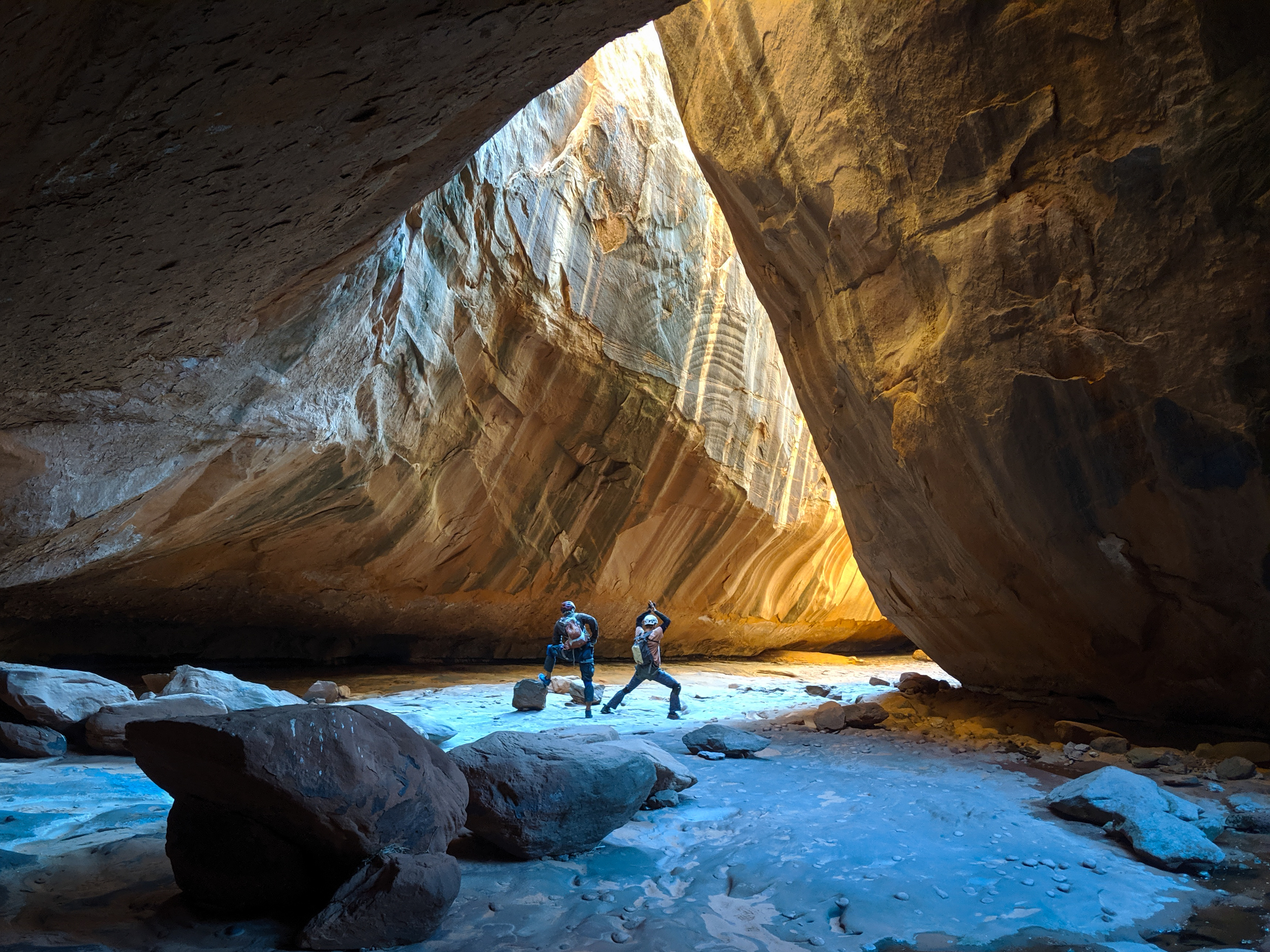
This open area is the start of the lower X-Section, which some people hike up to do on its own. The lower canyon is about 45 minutes long, and is very different in character from the upper canyon. It is similar in nature to DDI and easier than the upper sections of the canyon. At the end of the lower section, it becomes clear that you need to work your way down to the ground, you can directly down-climb from where it starts to open up, but you can go back up-canyon a bit for an easier down-climb and walk out the bottom. The Canyon then opens up into the cathedral, the most scenic part of the canyon. The large subway shaped cathedral has amazing light in the afternoon, as well as a spring with drinkable water coming straight out of the rock.
From the cathedral to Coyote Gulch the canyon is mostly open, though there are still two rappels. The first is under 75 feet depending on where you set your anchor, and the second is around 50 feet. This final rappel can be down-climbed on the RDC, but it is pretty sketchy with huge penalty points if you botch it. The scenic pool at the bottom of the rappel marks the end of the canyon.
Exit
Once you reach Coyote Gulch, head up-stream a few miles until you connect with the trail that you used to get down there, and follow that up to the trail-head.
Red tape
None
Beta sites
 Super Amazing Map : PINTAC
Trip reports and media
PINTAC (2005) by Nat Smale on Canyon Tales
PINTAC & DDI trip reports on Canyon Collective
Background
The canyon was first descended by Steve Allen in 1996.