Panther Creek (Mount Rainier National Park)
| Rating: | |||||||||||||||||||||||||||||||
|---|---|---|---|---|---|---|---|---|---|---|---|---|---|---|---|---|---|---|---|---|---|---|---|---|---|---|---|---|---|---|---|
| | Raps:2-4, max ↨55ft
Red Tape:No permit required Shuttle:None Vehicle:Passenger | ||||||||||||||||||||||||||||||
| Start: | |||||||||||||||||||||||||||||||
| Parking: | |||||||||||||||||||||||||||||||
| Condition Reports: | 13 Aug 2025
"Beautiful day in Panther.. Be aware that construction is prohibiting direct access to the bridge for entrance and exit. Plan on entering the hike |
||||||||||||||||||||||||||||||
| Best season: | Jul-Sept
|
||||||||||||||||||||||||||||||
| Regions: | |||||||||||||||||||||||||||||||
Introduction[edit]
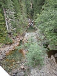
Panther Creek is a short but very scenic canyon in Mount Rainier National Park. It is a high-flow creek with a large drainage and may be dangerous to run early in the season; the creek can flow high even into late summer. The canyon features some interesting geology and one of the biggest logjams you're likely to find in a canyon route in Washington. It is a very photogenic canyon that gets bonus points for an easy approach and exit. Make it a full day of canyons by combining Panther with either Deer Creek, just up the road, or Middle Summit Creek, only 20 minutes away.
Approach[edit]
There's parking on either side of the bridge. From the North side head up into the fairly open forest. Simply parallel the creek, staying just far enough away from the creek to avoid steep parts that appear and disappear. You may catch a few glimpses of the waterfalls in the canyon as you approach. Continue until you reach a wide gully at around 46.7896, -121.5493. Traverse down into the gully easily to the creek.
An alternative option is to drop-in early, aiming to land in the creek just downstream of the jog-jam. In 2024 this was done via a short steep & dirty down-climb followed by a 90ft dry-rappel. Finding a more sustainable approach which achieves cutting out awkward log-jam traversal would be a great goal.
Descent[edit]
As with any canyon, be sure to check any pools for depth before jumping. Some pools in this canyon can be surprisingly shallow.
While not very deep, there are sections of this creek that are committing, particularly the last 2 rappels. There are several potential emergency exit points within the canyon but could be quite exposed and have not been attempted.
Just downstream from the drop-in you'll encounter an enormous logjam. Navigate your way over the logs very carefully, as they can be deceivingly loose. DCL appears to be the easiest path. Just around the corner from the logjam you'll reach the first series of pools.
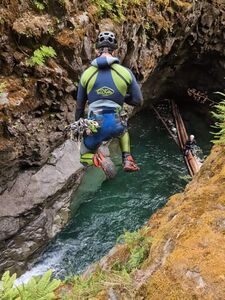
R1: 7' jump into a shallow pool, or downclimb DCR.
R2: 20' from a tree cluster up high DCR. This is a two-tier pool sequence. You will need to downclimb slightly DCR, then directly up to reach this anchor.
R3: 35' from a log DCL. Or downclimb DCR to a jump platform for a 15’ jump into a deep pool.
R4: 7' jump, downclimb, or slide.
(Sept 2023: I did not keep track of the drops in the canyon, but one of these last 2 pools has MANY shallow boulders. Down-climbing options are moderately advanced. Recommended to set an anchor.)
R5: 40' from a tree DCR. An exposed DCL traverse to the root ball of a huge log makes for a jump into the deep pool.
R6: 30' from a cairn anchor (more appropriately: thick branches held in place by multiple large rocks) DCR. Or jump from ledge DCR into a widening deep pool. An 8mm Petzl Pulse hole can be found at roughly chest-height at the far end of the ledge to back up the anchor. A technical climb allows this jump to be repeated. (In previous years it sounds like the water-course slot had been rappelled, but for clarity, this has been removed until it's reconfirmed).
Exit[edit]
Follow the creek back to the bridge and hike up to the road where your cars are waiting.
Red tape[edit]
Although the creek is inside the national park boundary, using SR 123 does not require a national parks pass or entry fee.
Beta sites[edit]
Trip reports and media[edit]
Background[edit]
Descended by Jake Huddleston and Kevin Steffa in October 2019. Webbing was found at the last drop indicating the canyon had been previously descended by another group. No signs of fixed anchors anywhere else in canyon. Date of first descent unknown.


