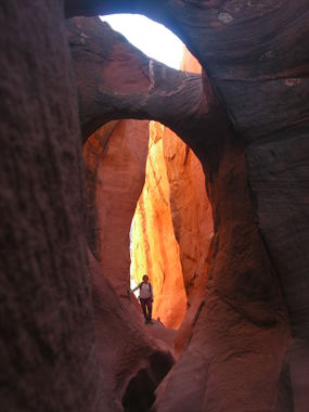
Peek-a-Boo Canyon
| Rating: | |||||||||||||||||||||||||||||||
|---|---|---|---|---|---|---|---|---|---|---|---|---|---|---|---|---|---|---|---|---|---|---|---|---|---|---|---|---|---|---|---|
| | Difficulty:2A I (v1a1 I) Raps:
Red Tape:No permit required Shuttle: | ||||||||||||||||||||||||||||||
| Location: | |||||||||||||||||||||||||||||||
| Condition Reports: | 4 Oct 2023
"Kids were 2-7 in age. We backpacked the littlest one through about half of the slot and almost all of the approach and exit. The kids did great but th |
||||||||||||||||||||||||||||||
| Best season: | Any;HOT in Summer
|
||||||||||||||||||||||||||||||
| Regions: | |||||||||||||||||||||||||||||||
Introduction[edit]
Fun non-technical slot canyon, perfect for kids of all ages. Easy to combine with nearby slot canyons like Spooky Gulch.
Approach[edit]
The approach follows a wide but exposed trail to a slickrock ridge. The trail follows a cliff band until descending some exposed slickrock to the wash below.
It is possible to access the area from the Upper Dry Fork Trailhead, which is longer but does not require scrambling on slick rock.
Descent[edit]
If running peek-a-boo up canyon, the entrance can be scaled using some steps carved into the sandstone and minor wedging to reach the top of the 30 foot class 4 climb. Halfway up the climb is a good shelf to regroup.
Exit[edit]
Red tape[edit]
The Lower Dry Fork Trailhead and parking area was moved [1]. This added about 1 mile one-way to the hike. At the time of this writing OpenStreetMap is more up-to-date than Google Maps, because OSM shows the new road and trailhead and marks the old road as permanently closed, but Google has an outdated lower dry fork trailhead marker, road path, and outdated satellite imagry. Across various online sources (blogs, beta sites, etc), it is easy to read about old information. You can differentiate this by discussion about a road and trailhead to the northern cliff band which no longer exists. It is nearly impossible to identify the old road in-person. The tracks and waypoints in the ropewiki map are up-to-date.
Beta sites[edit]
 BluuGnome.com : Spooky and Peekaboo
 RoadTripRyan.com : Peekaboo
 CanyonChronicles.com : Peekaboo Canyon
 Climb-Utah.com : Dry Fork Canyons
 HikeArizona.com : Slot Canyons of Dry Fork Coyote Gulch
 CanyonCollective.com : Peek-a-Boo
 Super Amazing Map : Peek-a-Boo Canyon
 AmericanSouthwest.net : Peekaboo Gulch
 CanyoneeringUSA.com : Dry Forks; Coyote Gulch: Peek-a-Boo; Spooky & Brimstone Canyons
 ZionCanyoneering.com : Peek-a-Boo
 ZionCanyoneering.com : Peek-a-Boo Canyon
Trip reports and media[edit]
- see this post on the dead cow
- https://www.facebook.com/pat.winstanley.7/media_set?set=a.890200321038666.1073741965.100001461198708&type=3
 Candition.com : Peek-a-Boo
 Youtube.com : Richard Pattison, Peek-a-Boo & Spooky movie
