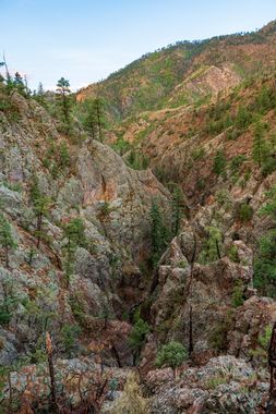
Peralta Canyon Narrows
| Rating: | |||||||||||||||||||||||||||||||
|---|---|---|---|---|---|---|---|---|---|---|---|---|---|---|---|---|---|---|---|---|---|---|---|---|---|---|---|---|---|---|---|
| | Difficulty:3B IV (v3a2 IV) Raps:3-4, max ↨
Red Tape:No permit required Shuttle: Vehicle:High Clearance Rock type:Granite | ||||||||||||||||||||||||||||||
| Start: | |||||||||||||||||||||||||||||||
| Parking: | |||||||||||||||||||||||||||||||
| Condition Reports: | |||||||||||||||||||||||||||||||
| Best season: | Likely best in spring, though still flowing in summer.
|
||||||||||||||||||||||||||||||
| Regions: | |||||||||||||||||||||||||||||||
Introduction[edit]
Five Falls canyon, were it near a road, would be a brief but excellent canyon. However, the miles of thorny and truly impressively thick bushwhacking and deadfall hopping required relegates this canyon to those few who will enjoy the whole journey, pain and all. Were the Peralta trail ever repaired, this would surely be a canyon not to miss.
Even during a dry July, there was constant flow. Google earth imaging shows significant flow during spring runoff.
Approach[edit]
Starting on FS road 266 (Blocked by deadfall several miles west of the ridge), follow Peralta Ridge Trail (The trail no longer exists, and you will be bushwhacking). Once in Peralta Canyon proper, climb over/under constant deadfall for two miles until you reach the narrows.
Descent[edit]
Flowing canyon of slippery when wet granite. Natural anchor solutions to be had, 3-4 raps.
Exit[edit]
Once you exit the narrows, scramble directly north up ~100ft of scree, and side slope until back in the watercourse above narrows. Follow approach footprints back to vehicle.
Red tape[edit]
All forest service, no red tape.
