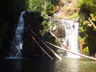
Pin Creek
| Rating: | |||||||||||||||||||||||||||||||
|---|---|---|---|---|---|---|---|---|---|---|---|---|---|---|---|---|---|---|---|---|---|---|---|---|---|---|---|---|---|---|---|
| | Raps:5-6, max ↨60ft
Red Tape:No permit required Shuttle:Optional 5min Vehicle:Passenger | ||||||||||||||||||||||||||||||
| Start: | |||||||||||||||||||||||||||||||
| Parking: | |||||||||||||||||||||||||||||||
| Shuttle: | |||||||||||||||||||||||||||||||
| Condition Reports: | 7 Sep 2025
"The water keeps dropping in Pin. It looks like water in the pool before R1 might be draining out through a new syphon. I usually swim this pool but co |
||||||||||||||||||||||||||||||
| Best season: | Jul-Sept
|
||||||||||||||||||||||||||||||
| Regions: | |||||||||||||||||||||||||||||||
Introduction[edit]
Another nice tributary along the Lewis River containing a beautiful section of narrows, pools, and waterfalls concluding with Pin Creek Falls (35ft). Access is easy and straightforward. A short outing, but all-around fun. Expect much jumping. Destined to be another classic in the Lewis River area.
- Watershed: 8.5mi^2. Highest point in the drainage is about 5200ft on Quartz Creek Ridge.
Approach[edit]
Stash a shuttle car at the exit where Pin Creek crosses under FR 90. This is also a good place to check the flow. Drive up FR 9085 to the first switchback and find a place to park; there's room for several cars.
From the parking area, hike roughly northwest through open forest for ~5min until dropping into Pin Creek. Head downstream. Reach the top of the technical section in 5-10min.
- Shortcut approach: This option cuts off some of the pretty parts of the creek-walking. Entry into the creek is pretty steep, but it drops you right in above the narrow chute leading to R1.
Descent[edit]
For such a short section of creek, Lower Pin is surprisingly action-packed. It retains enough water to be fun into September. Be aware: jumps are a leading cause of canyon injuries (broken ankles & legs). Always send someone down to check the depth first & check for submerged obstacles.
Please do not leave webbing on unlinked bolts. This is a common technique in aquatic canyons.
- The creek turns a corner and descends a 30ft low-angle chute. If high flow, bypass DCR.
Continue downstream a short distance. Upon turning the next corner:
- Climb down to narrow opening. This is currently deep enough to climb up the rocks on either side and jump into the water. Caution: The logs above are getting rotten! R1 is on the far side of the pool.
- R1: 35ft from two bolts DCR. (There are two bolts DCL on the far side of the pool below if you want to rig a guided rappel.)
- R2: 25ft from vertical log in the pool. High flow: use a tree far DCR.
- R3: 50ft rappel ... or downclimb to a nice 8ft jump (or relatively easy bypass). Then downclimb easily past a second small cascade or second short jump.
- R4: 60ft from unlinked bolts (both DCL and DCR; DCL will put you in more flow) into The Punchbowl.
The Punchbowl is a terrific place to practice jumps at many different heights. The pool has been measured at ~20ft deep at its center in 2022. For the action seekers, climb up onto a huge old-growth log just over the pool (aka the Diving Board) and jump 25ft (measured 2025/9/7) into the pool. Awesome!
- R5: 25ft from single bolt DCR. Alternatively, jump or carefully downclimb DCR. Be sure to scout the pool carefully as some places are deeper than others. High water: bypass the chute from DCL; not a lot of great anchor options.
- R6: Pin Creek Falls 35ft. There are several options. This waterfall is visited regularly by waterfall photographers, so please use unobtrusive webbing.
- Low-moderate flow: Locate a small tree DCL and rig a 30ft retrievable traverse line down to an unlinked bolt station (glue-ins) just above a small pothole / bathtub on the left side of the falls. (As of September 2023, there's also an older bad expansion bolt here that should probably be decommissioned.)
- High flow: rappel from a tree DCR.
Exit[edit]
Head downstream 5min from the last falls to reach the bridge. To avoid bank erosion, pass under the bridge and find an easy exit immediately DCL.
- Alternatively, if you don't have a shuttle, it's an easy hike back up through the forest. Takes about 15min.
Red tape[edit]
None.
Beta sites[edit]
Trip reports and media[edit]
Chapters in this video match the Ropewiki beta:
Background[edit]
First known descent of Pin Creek was made by Keith Campbell in August 2017.


