Porcupine
| Rating: | ||||
|---|---|---|---|---|
| | Difficulty:4B III R (v5a2 III) Raps:6-8, max ↨70ft
Red Tape:Permit required Shuttle: | |||
| Location: | ||||
| Condition Reports: | 29 Apr 2018
"12 hours round trip from camp in West Canyon at the end of Humble Beginnings (Ocelot) including the first 70 foot drop - water was low so geometry for |
|||
| Best season: | ||||
| Regions: | ||||
Introduction[edit]
Approach[edit]
Descent[edit]
Porcupine Canyon is beautiful and fun. It is also very technically challenging and might require every trick that you have in your bag. Due to the very tricky nature of the final section, this canyon is recommended for advanced/expert canyoneers only.
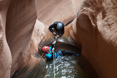
We skipped the very top section and entered from the side here: 36 57' 22" N 111 04' 60" W. Soon you will arrive at an 70 foot drop from a large pothole. When we arrived the pothole was completely full which made our water anchor placement very tenuous. If you can’t manage to keep your water anchor from failing at this drop, walk around the south rim of the canyon and enter further down the canyon. There is no shame in giving up on your water anchor at this drop, the geometry is unfavorable and dangerous, and you won’t be missing much of the slot if you bypass this section.
36 57' 12.5" N 111 05' 32" W is a good place to warm up before the REAL action begins.
The remainder of the canyon will require 6-8 rappels depending on the conditions. The final rappel is 60 feet. You could probably do the entire canyon with 2 X 100 foot ropes, however, we brought a 220 foot rope that we used to link potholes and speed up the final section, so we were glad to have it.
There is no doubt in my mind that the difficulty of this canyon will vary considerably as the water level changes, so it is nearly impossible to write a complete and thorough set of beta for Porcupine. Approach this canyon each and every time as if it were an exploration. Be prepared for anything!
There are many serious potholes in the lower section of Porcupine. We used one Fiddlestick, two SandTraps, and two water anchors to get past all of the obstacles. Do not expect to use this same combination of anchors! Again, be prepared for the unexpected!
The use of a water anchor was mandatory in this canyon, so don’t be an idiot and go into this canyon without one. To do so would be suicide.
Rating: 4BIII R
Time: We completed this loop in 9 hours in exploration mode (slow and very cautious pace). 7-8 hours would be a reasonable pace for us the second time through.
Rappels: 6-8 depending on the conditions. The first optional rappel is about 70 feet. The last rappel is about 60 feet.
Mandatory Equipment: Water anchor, Fiddlestick, SandTrap, SandTrap pullcord sheathed with webbing, 2x100 feet of rope. In low water conditions Potshots might be required. I recommend bringing an additional short rope and a long rope as well, 50ft and 200ft would work nicely.
Neoprene: 5/4mm full length suits, booties, gloves, vest, hood, beanie. 7mm suit if you get cold easily.
Please play fair and do not add bolts to this route. We were able to ghost Porcupine with moderate effort.
Exit[edit]
Red tape[edit]
Hiking in this area requires a permit from the Navajo Nation. I recommend mailing your permit request a few weeks in advance, along with a very polite letter explaining your trip itinerary. Permit information can be found here:http://navajonationparks.org/permits.htm
Beta sites[edit]
 Super Amazing Map : Porcupine
https://amazingslots.blogspot.com/2017/05/west-canyon-beta-lake-powell.html
Trip reports and media[edit]
http://amazingslots.blogspot.com/2017/04/west-canyon-2017-porcupine-canyon.html
