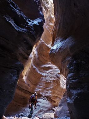
Primo Canyon
| Rating: | |||||||||||||||||||||||||||||||
|---|---|---|---|---|---|---|---|---|---|---|---|---|---|---|---|---|---|---|---|---|---|---|---|---|---|---|---|---|---|---|---|
| | Difficulty:3A III (v3a1 III) Raps:2-3, max ↨35ft
Red Tape:Permit required Shuttle:Optional 30 min Vehicle:4WD - High Clearance Rock type:volcanic conglomerate | ||||||||||||||||||||||||||||||
| Location: | |||||||||||||||||||||||||||||||
| Condition Reports: | 9 Dec 2024
"This was a cool and unexpected slot canyon. Im glad we did it, but not sure I would do it again. We did the canyon as the start to a 2 day backpackin |
||||||||||||||||||||||||||||||
| Best season: | spring, fall, winter
|
||||||||||||||||||||||||||||||
| Regions: | |||||||||||||||||||||||||||||||
Introduction[edit]
A trip through a fairly long, mellow canyon with a few short rappels and wonderful narrows at the end. A permit for hiking in the Aravaipa Canyon Wilderness is required for the hike.
From the small town of Eden, AZ, on AZ 70 between Ft Thomas and Thatcher, turn west on Klondyke Rd between mileposts 313 and 314 shortly after a green highway sign for Aravaipa and Klondyke Rd. Drive southwest on this well graded dirt road for 24.7 miles to turn right at a T intersection to stay on Klodyke Rd. Drive north on Klondyke Rd for another 15.7 miles to reach the east trailhead for Aravaipa Canyon, or for 17.5 miles to the Turkey Creek trailhead. There are several creek crossings along the way, and a few more if continuing to the Turkey Creek trailhead.
A shuttle is not mandatory to complete the canyon, but will save you 4.3 miles of road hiking.
Approach[edit]
Hike or drive the road from the trailhead of your choosing to travel northeast up Bear Creek Rd where it meets the main road at the Aravaipa East trailhead - the road is decent gravel that is a bit soft for hiking, but not terrible. Follow the road as it travels up the wash of Bear Creek, then up the slope on the left, turning left onto a much more minor road atop a ridge after about 2.4 miles on this road - if you have dropped a shuttle car at either the Turkey Creek or Aravaipa Canyon trailheads, park and start the hike here. Follow this overgrown road down the ridge, across a shallow drainage, then down the next ridge looking for a relatively low angle line down the fairly steep, rocky slope to descend into the canyon - mileage from leaving Bear Creek Rd to the canyon should be about .7 mile.
Descent[edit]
The upper canyon has a good stretch of nice, though somewhat shallow narrows, without any real vertical obstacles. After the upper section the canyon opens to roughly a mile of easy, more open gravel hiking before reaching the technical section and the short, but beautiful narrows at the end of the drainage. The first drop encountered can be rappelled (no anchor, 25 feet) or climbed around on the left through a series of decent ledges with one or two somewhat exposed and tricky intermediate climbing moves along the way. The next drop is anchored from a pinch point ten feet back from the drop in the watercourse down a nice, sculpted chute requiring 35 feet of rope. Shortly after is the last drop in the canyon of 35 feet from a pinch point under a boulder above a rabbit hole (does not go all the way to the canyon floor - this drop must be rappelled). Enjoy the deep scenic narrows for the remaining short distance to the confluence with Aravaipa Creek.
Exit[edit]
Turn left to hike generally east up Aravaipa Creek back to wherever you staged your vehicle - a trail can be found on the left in fairly short order if trying to stay out of the creek.
Red tape[edit]
Permits and area information can be found here:
https://www.recreation.gov/wildernessAreaDetails.do?contractCode=NRSO&parkId=74989
Permits do fill up quickly, so plan ahead.
