Quartz Creek (South Cascades) Canyoneering Canyoning Caving
|
| Rating: |
Log in to rateLog in to rateLog in to rateLog in to rateLog in to rate 3.1 (3 ratings) |
|
|
| |
Raps:6, max ↨100ft No Shuttle:Optional 5 mins |
|---|
| Start: |
|
|---|
| Parking: | |
|---|
| |
|---|
| Condition Reports: |
21 May 2025
"First descent trip, after a day of rain so we had some fun sporty flow. Worthwhile canyon if you are in the area. Took us 4 hours including bolting/sc
(log in to submit report)
|
|---|
Weather: |
|
|---|
| Best season: |
Spring to Autumn, BEST in Spring | winter | | spring | | summer | | fall |
|---|
| Dec | Jan | Feb | | Mar | Apr | May | | Jun | Jul | Aug | | Sep | Oct | Nov |
|
| Regions: |
|
46.3595, -122.053446.3622, -122.0548topo
GPS data automatically extracted from [], please visit their site for more detailed information.
Automatic GPS data extraction NOT allowed, please visit [] to download GPX.
Reference photos
21 May 2025:
Moderate-High. A bit high, quite challenging but not too dangerous (class C1+ = a4+).
These reference pictures are used in the
Waterflow analysis to predict current conditions. More reference pictures will produce a more reliable prediction.
(log in to submit reference picture) | Welcome! Canyons in the Pacific Northwest can be different from those you might be used to. Be ready for unlinked bolts, retrievable traverse lines, and challenging aquatic environments. For more on local practices, and the best way to get started in the region, check out the WCC Safety page.
- Unlinked Bolts - groups should be comfortable rigging unlinked bolts, either temporarily linking them for all but the last person, or using a passive redundancy method. Most importantly, if you find two bolts side by side that are unlinked, do not add webbing to them. Linking bolts designed to be unlinked will likely cause damage during seasonal floods.
- Traverse Lines - many canyons are rigged to allow traverse line access to an exposed anchor station. This should be done using self-belay or team belay techniques. Do not leave fixed lines in the canyons.
- Challenging Environments - the highly aquatic nature of PNW canyons can surprise many. Cold temperatures, slippery rocks, loud waterfalls, and strong currents all lead to unexpected problems. Do not underestimate the need for strong team work and technical proficiency. Belays are frequently not possible. Unattended gear will sink or float away. Sliding and jumping is the cause of most major injuries, so it's critical to effectively communicating water depth & submerged hazards.
|
Introduction[edit]
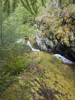
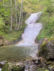
The stream cuts away at a cliffside for the first few drops in a very narrow fashion before dropping into a lovely bedrock walkway with steep canyon walls. After a short walk, there are two more drops that the entire stream fans wide over some low angle falls. Probably not worth it by itself but a great one to combine with strawberry falls.
Approach[edit]
From parking/ last switchback, Hike about 100 vertical feet up into the trees. You'll see the first drops there.
Descent[edit]
R1: tree DCL. 50 feet. This could also be set up as traverse line. Follow narrow horizontal chute.
R2: 2 bolts DCL. 40 feet. Bolts are located where the narrow chute turns DCR 90 degrees. Rappel down a slippy ramp that ends in 3 foot deep pool with small undercut which could pose a hazard in high flow.
R3: 1 bolt DCL. 100 feet. Flow will concentrate DCR and is quite pushy in moderate high flow. Stay DCL for less flow. Rappel until reaching shelf with horizontally growing trees DCR.
Next fall is 20 feet. The first descent downclimbed DCR. There were plenty of rocks to build cairn anchor if you wish to rappel the fall.
R4: tree DCR. 40 feet
A bit of creek walking.
R5: tree DCR. 80 feet low angle
R6: group of small trees DCR. 80 feet
Walk 50ft from the last falls back to the road.
Red tape[edit]
Beta sites[edit]
Trip reports and media[edit]
Scouting video
Background[edit]
_Banner.jpg)
-20250523080607_pic.jpg)
_rap2.jpg)
_rap3.jpg)
_rap4.jpg)
_creek.jpg)
_rap6.jpg)