Quicksilver Creek
| Rating: | |||||||||||||||||||||||||||||||
|---|---|---|---|---|---|---|---|---|---|---|---|---|---|---|---|---|---|---|---|---|---|---|---|---|---|---|---|---|---|---|---|
| | Raps:5-7, max ↨70ft
Red Tape:No permit required Shuttle:None Vehicle:Passenger | ||||||||||||||||||||||||||||||
| Location: | |||||||||||||||||||||||||||||||
| Condition Reports: | 25 Aug 2025
"New green slimey-sludge this season compared to last year (or previous years). I suspect it may be invasive to the watershed.. For future trips, P |
||||||||||||||||||||||||||||||
| Best season: | july-september
|
||||||||||||||||||||||||||||||
| Regions: | |||||||||||||||||||||||||||||||
Introduction[edit]
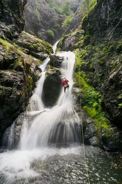
Quicksilver Canyon is a half mile section of Silver Creek in the Wenatchee National Forest east of Snoqualmie Pass. The canyon contains 2 small jumps (12 feet), one pseudo slide, and 5 rappels in a mostly open creekbed. It is notable for its extremely frigid water (even in mid-August), and wind especially above the narrows. It has a reasonable pay-to-play ratio, with an approach entirely on trail, and a mix of features including interesting rigging. The canyon is within a 90 minute drive of Seattle.
Groups should be prepared to reach exposed anchors using retrievable traverse lines and to use unlinked bolt anchors (webbing-less bolts).
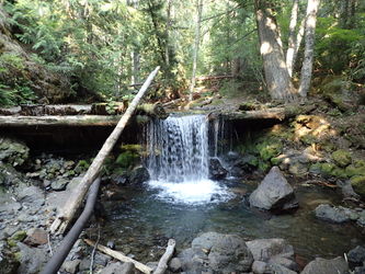
To check water flow, follow the creek upstream 2 minutes from the parking lot to a small man-made dam and check the pourover.
Approach[edit]
Proceed up the Kachess Ridge Trail for 1.3 miles until the trail nearly meets the creek. There is a small but obvious trail leading down to the creek right above the first jump. Great flat rocks there to change.
Descent[edit]
Check the pool depth for any obstructions prior to any jumps. Use extra caution as the rock in this creek is very slippery.
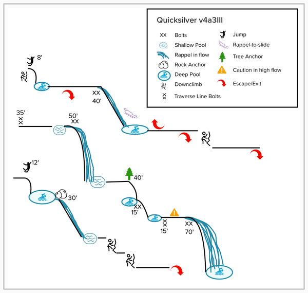
J1: 8' (optional). Jump from the top or scramble out to a ledge DCR and jump. Alternatively, downclimb DCR past a series of little potholes.
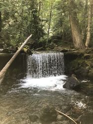
R1: 40' bolts DCR. Rappel the whole way, or rappel down part way and slide the rest. (Optional traverse line bolts 15' back from edge).
After R1 head DCR across slabs to cut the corner. There's a small DCL downclimb (protectable via webbing), which alternatively can be rapped mid-canyon from a log when there's a fun amount of flow.
R2: 50' bolts DCL. This anchor is very exposed. A pair of traverse line bolts have been set up DCL to approach this anchor. Traverse line is approximately 35'. Please rig a retrievable traverse line - do not leave rope behind! Fixed traverse lines present a hazard to other groups, potential for anchor damage from debris, and make the canyon look messy.
R2 commits you to the canyon. It may be possible to escape DCR between R2 and R3, but the hillside is loose scree and would be very difficult and potentially dangerous to climb.
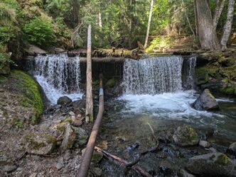
R3: 40' DCL to the rebelay, or 50' to the 2nd pool. This anchor has traditionally been off of a tree DCL, but that line crossed a lot of loose rock causing nearly unavoidable rockfall. There are now a pair of unlinked bolts center-left, creating a great line and a great pull. These bolts are positioned in winter flow, so as of fall 2021, the webbing remains on the tree until we see how the bolts fair the winter. There is a rebelay at the base of the hanging pothole DCR. This hanging pothole can be jumped from a ledge about half way down, but check depth as there are areas that are shallow or undercut.
R4: 15' bolted rebelay DCR. Take special care when exiting the pool at the very bottom as it is slippery and uneven, and the pool leads directly to the next big falls. First person down should consider necessary protection to assist others out of the pool. At moderate flow, this exit is not pushy, but high flow could be especially dangerous.
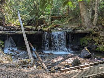
R5: 70' bolts DCR. This anchor is very exposed. Traverse line bolts have been set up DCR to approach this anchor. Traverse line is approximately 15'. Please use a retrievable traverse line.
Note: These are unlinked ring bolts and are meant to be used without webbing. DO NOT ADD WEBBING TO THIS ANCHOR! Webbing here increases the potential for anchor damage from floods/debris. All unlinked ring bolts in the canyon should be temporarily linked for redundancy in rigging, but left unlinked after the rope pull
J2: 10'-12' DCL into a pothole.
R6: 30' DCL from webbing around a chockstone. There is a deviation DCL about halfway down the pitch, which protects you from an unpleasant swing into the pothole.
Exit[edit]
Scramble down the creek about 200yds until the walls DCR eventually taper out. There is a noticeable change as you leave the pine forest and enter into hardwoods. Shortly after entering the hardwoods, keep an eye out for pink flagging on the ends of cut branches on the right. Follow flagging into the forest and traverse the hillside, avoiding gaining too much elevation at first (if you reach a loose scree field or get cliffed out, continue to traverse left). Soon the brushy forest opens up to more grassy meadows. Traverse uphill to first ridge line. The flagging ends here so that it is not visible from the hiking trail. From here, traverse down to cross the gully on an established deer trail and reenter the forest, traversing gradually upward until you link up with the Kachess Ridge trail. Proceed downhill back to the parking lot.
Red tape[edit]
Beta sites[edit]
Trip reports and media[edit]
Background[edit]
Quicksilver canyon was first descended on July 6, 2019 by Jake Huddleston, Haruka-James Lipscomb, Kevin Steffa, Michael Henson, and Tiffanie Lin. We learned that the walls of the canyon DCR are a little over 200 ft tall because Tiffanie left her backpack at the top of a drop and had to retrieve it. While walking the ridge was beautiful, rappelling into the canyon is not advised as the ground is covered in loose scree, sharp rocks, and rockfall is a reality.
It was named Quicksilver Canyon to avoid confusion with nearby Silver Creek Canyon along the North Fork Skykomish River.
